A predictive low-latency geographic routing method

A geo-routing and low-latency technology, applied in the field of geo-routing in wireless sensor networks, can solve the problems of high latency, uneven energy consumption, serious energy consumption and time consumption, and empty detours, so as to prolong life and reduce energy consumption. , The effect of balancing network load

Active Publication Date: 2019-07-12
XIANGTAN UNIV
View PDF4 Cites 0 Cited by
  • Summary
  • Abstract
  • Description
  • Claims
  • Application Information

AI Technical Summary

Problems solved by technology

[0005] Aiming at the problems of high delay, uneven energy consumption and hole bypass in the wireless sensor network geographical routing protocol, when there are many nodes in the wireless sensor network, the energy consumption and time consumption of node broadcasting and transmitting information are more serious

Method used


Image

  • A predictive low-latency geographic routing method
  • A predictive low-latency geographic routing method
  • A predictive low-latency geographic routing method

Examples


Embodiment Construction

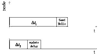
[0021] 1) Define the Hello protocol packet: add three new fields in the packet header, respectively carrying the average receiving rate of node data packets p in , the average packet sending rate p out and the node's current queue size Q cur_size Three messages; the node calculates the average receiving rate p of data packets in and the average sending rate p out ,Methods as below:

[0022]

[0023]

[0024] where t in is the time interval between two adjacent packets arriving at the node, t out is the time interval between two adjacent packets leaving the node, k, k>1, k∈N + Indicates the number of calculations, and α is a scaling factor whose value ranges from 0 to 1.

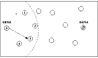
[0025] 2) Each node maintains a neighbor table to store the information of its neighbor nodes, mainly including neighbor node number, coordinate position, average data packet receiving rate, average data packet sending rate, current queue size of any neighbor node, neighbor node The prediction de...


PUM


Abstract

The invention provides a predictive low-delay geographical routing method. The method is mainly used for solving the problem of unbalance between geographical routing delay and network energy consumption in the prior art, and the bypassing efficiency of a routing void is improved. The method comprises the following basic steps: (1) setting a Hello protocol packet and a neighbor table, and broadcasting a hop of protocol packet by regarding delta t1 as a cycle through each node; (2) locally updating the neighbor table by regarding delta t2 as a cycle through each node; (3) determining a receiving process or a forwarding process which needs to be processed by each node, and correspondingly executing the step (4) or the step (5); (4) judging the type of a packet, if the packet is the protocol packet, globally updating the neighbor table, and otherwise, transferring the packet to an upper layer of each node; (5) greedily forwarding a data packet by each node, and if a void is formed to generate a local extreme value in the forwarding process, selecting an anchor node to continuously perform greedy forwarding by utilizing a tangent angle spread searching method.

Description

technical field [0001] The invention is a predictive low-delay geographic routing protocol method, which belongs to the field of geographic routing in wireless sensor networks. Background technique [0002] Wireless Ad Hoc network is a kind of wireless local area network without fixed infrastructure, and it is a kind of temporary network composed of some equal mobile nodes communicating with each other. The Ad Hoc network is simple and fast, and is widely used in some temporary major activities such as emergency rescue, high-risk industry, medical first aid, military field, and environmental monitoring. Although the Ad Hoc network is relatively convenient, each node in the network (the mobile station in the network is simplified as a node) must participate in the routing discovery and maintenance of other nodes, and due to frequent and rapid changes in the network topology, some fixed network routing protocols are not Not suitable for Ad Hoc networks. With the development ...

Claims


Application Information

Patent Timeline
Patent Type & Authority Patents(China)
IPC IPC(8): H04W28/08H04W40/02H04W52/02
CPCH04W28/08H04W40/02H04W52/02Y02D30/70
Inventor 李哲涛欧阳经纶裴廷睿田淑娟朱更明
Owner XIANGTAN UNIV
Why Eureka
Try Eureka