Classification method based on vehicle-mounted LiDAR point cloud data

A technology of point cloud data and normal vector, which is applied in the field of vehicle LiDAR point cloud data processing, and can solve the problems of complex identification of mixed arrangement points and complex processing process.

Active Publication Date: 2015-03-25
WUHAN UNIV
View PDF2 Cites 64 Cited by
  • Summary
  • Abstract
  • Description
  • Claims
  • Application Information

AI Technical Summary

Problems solved by technology

[0004] Foreign countries have developed a relatively ideal automatic classification and recognition algorithm for point cloud data in this field: such as an algorithm for classifying laser scanning point cloud data into different groups according to the point spatial distribution characteristics (geometric features, dispersion degree and density information) of cross-sectional scanning points , but the

Method used


Image

  • Classification method based on vehicle-mounted LiDAR point cloud data
  • Classification method based on vehicle-mounted LiDAR point cloud data
  • Classification method based on vehicle-mounted LiDAR point cloud data

Examples


Embodiment Construction

[0074] In order to make the object, technical solution and advantages of the present invention clearer, the present invention will be further described in detail below in conjunction with the accompanying drawings and embodiments. It should be understood that the specific embodiments described here are only used to explain the present invention, not to limit the present invention.

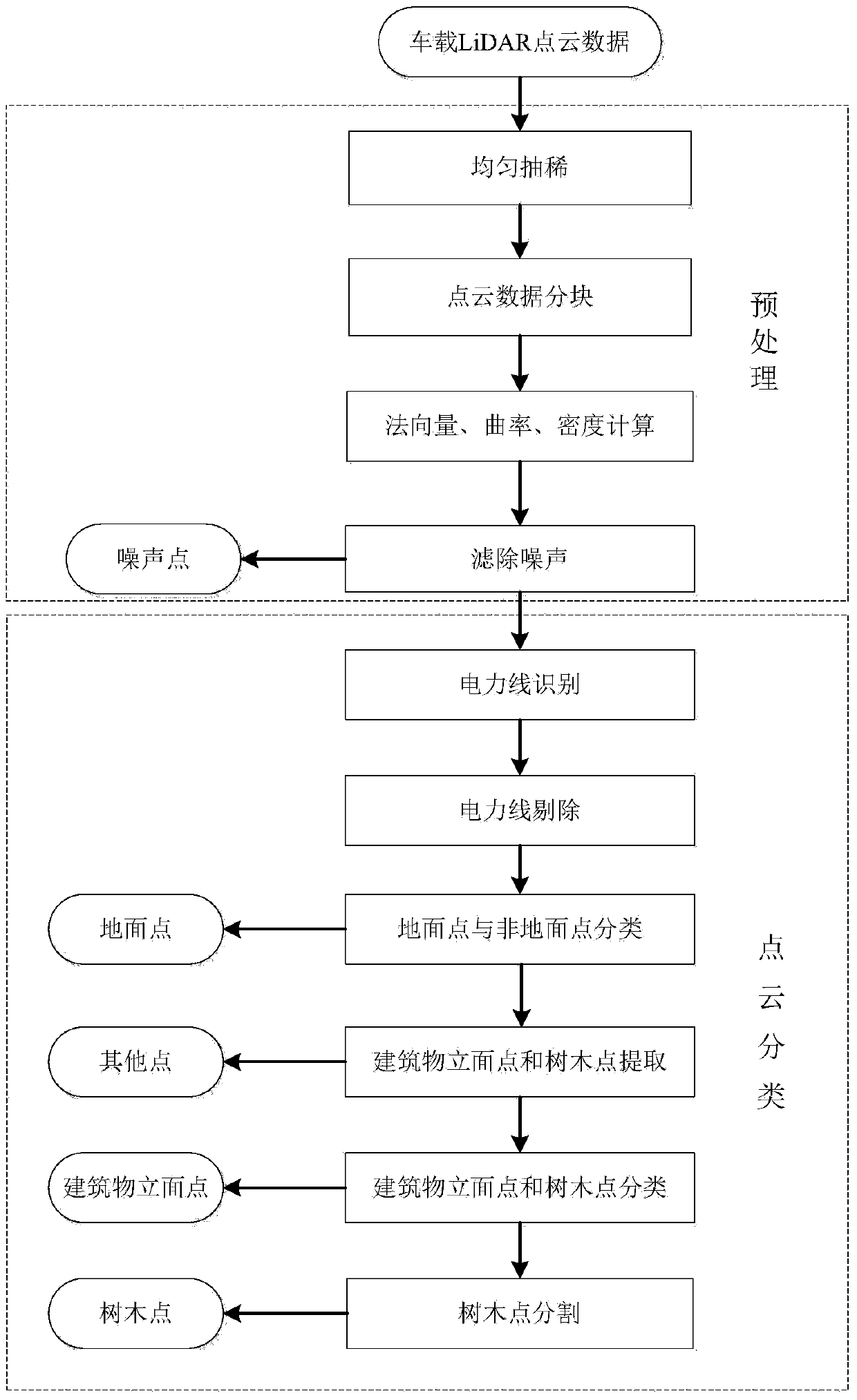
[0075] The embodiment of the present invention is based on the classification method of vehicle-mounted LiDAR point cloud data, comprises the following steps:

[0076] S1. Obtain the vehicle-mounted LiDAR point cloud data of the street view, and preprocess it to remove redundant data and noise in the point cloud data, and calculate the normal vector, curvature and density of the point cloud during the preprocessing process;

[0077] S2. Classify the preprocessed point cloud data, and extract power lines, building facade points, and tree points according to the normal vector, curvature, and density ...


PUM


Abstract

The invention discloses a classification method based on vehicle-mounted LiDAR point cloud data. The method comprises the steps that streetscape vehicle-mounted LiDAR point cloud data are obtained and preprocessed so as to remove redundant data and noise in the point cloud data, and the point cloud normal vector, curvature and density are calculated in the preprocessing process; the preprocessed point cloud data are classified; according to the point cloud normal vector, curvature and density, power lines, building vertical face points and tree points are extracted. According to the classification method, implementation is easy, calculated quantity is small, implementation is fast and effective, the foundation is laid for streetscape facet extraction, and facet extraction is more accurate.

Description

technical field [0001] The invention relates to the technical field of vehicle-mounted LiDAR point cloud data processing, in particular to a classification method based on vehicle-mounted LiDAR point cloud data that can effectively extract building points, power lines and tree points. Background technique [0002] With the digitalization of cities and the increasing demand for information technology, street view maps are developing more and more rapidly. As an advanced measurement method, vehicle-mounted laser scanning not only has the characteristics of fast, non-contact, real-time, dynamic, active, high-density and high-precision, but also can collect large-area three-dimensional space data and acquire buildings, roads, etc. The surface information of urban features such as vegetation and vegetation provides ideas for the extraction of street scene patches. Therefore, how to quickly and accurately classify vehicle-mounted laser point cloud data has become one of the first...

Claims


Application Information

Patent Timeline
IPC IPC(8): G06T7/00G06T5/00G06K9/62
CPCG06F18/241
Inventor 姚剑陈梦怡李礼鲁小虎
Owner WUHAN UNIV
Why Eureka
Try Eureka