Geological survey method of tunnel face based on digital image

A geological survey and digital image technology, applied in the direction of optical exploration, can solve the problems of cutting into dangerous objects, locomotives passing by, weak light, etc., and achieve the effect of improving the accuracy and efficiency of mapping

Inactive Publication Date: 2015-04-08
CHINA UNIV OF GEOSCIENCES (WUHAN)
View PDF3 Cites 29 Cited by
  • Summary
  • Abstract
  • Description
  • Claims
  • Application Information

AI Technical Summary

Problems solved by technology

In the actual tunnel excavation process, due to the influence of construction, there is usually a lot of dust in the tunnel, weak light, poor visibility, and frequent locomotives passing by. This traditional method is not only disturbed by many environmental factors, but also low in efficiency; more importantly It is because the structural surface of the hard-to-reach area above the tunnel face cannot be investigated

Method used


Image

  • Geological survey method of tunnel face based on digital image
  • Geological survey method of tunnel face based on digital image
  • Geological survey method of tunnel face based on digital image

Examples


Embodiment 1

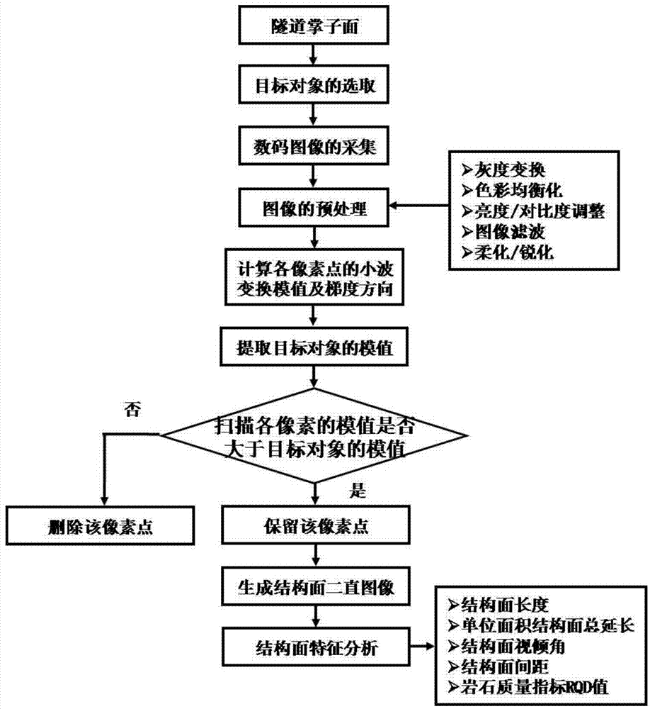
[0048] A digital image-based geological survey method for a face, the steps of which are:

[0049] The first step is to select the target structural surface, the specific steps are as follows:

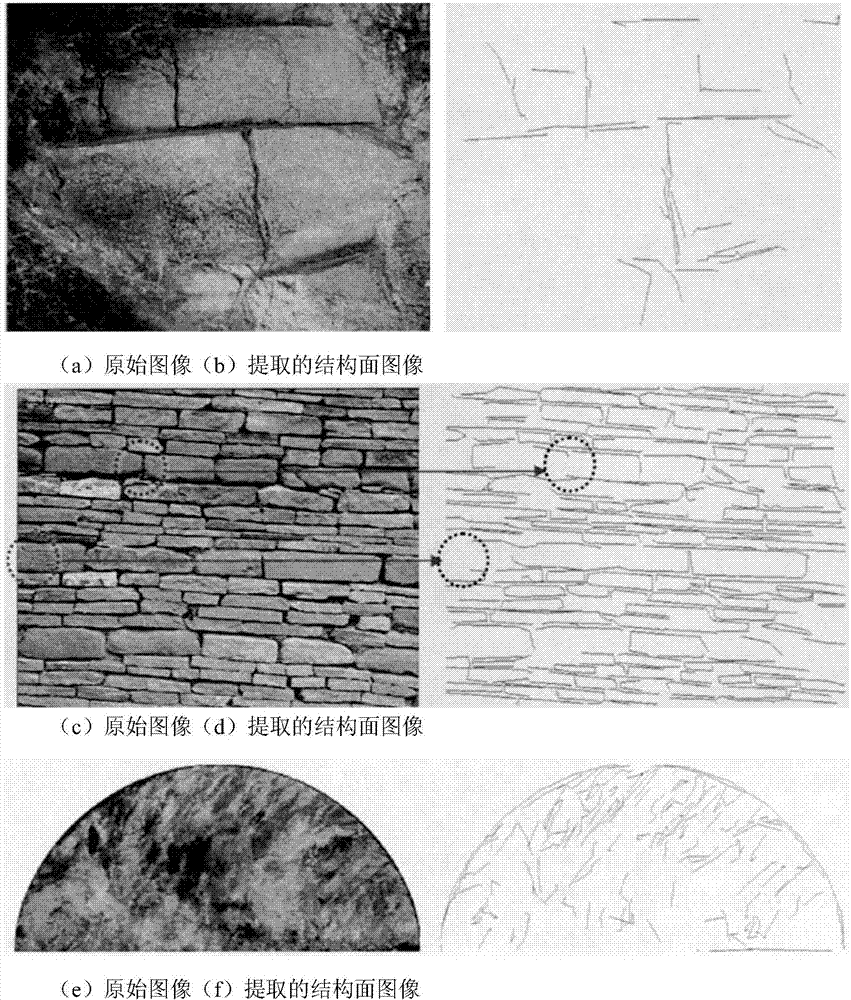
[0050] (a) After the tunnel face has been eliminated, there are many structural surfaces of different scales, such as rock formation boundaries, veins, joints, and fissures. According to the requirements, purpose and level of detail of the geological survey, select the smallest structure to be investigated face as the target object.

[0051] (b) Mark the selected target object with a reflective film.

[0052] The target object selects a crack surface of about 30cm, and the structural surface smaller than the target object will be ignored, and the target object can choose 1-3. At the same time, the target object should try to choose the middle and lower part of the face, but it must be clearly identifiable.

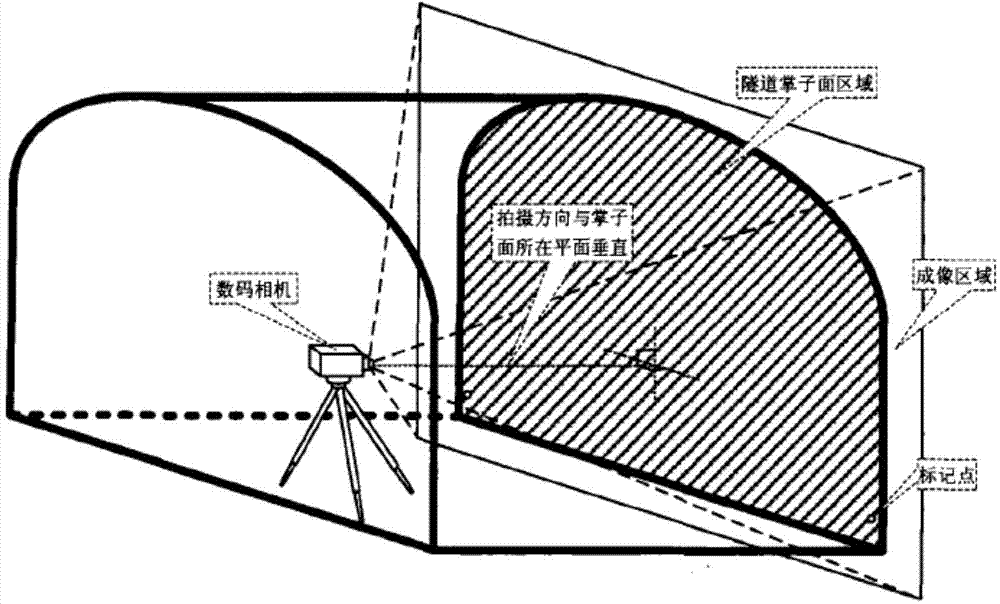
[0053] The second step is the collection of digital images of the tunnel fa...


PUM


Abstract

The invention discloses a geological survey method of a tunnel face based on a digital image. The geological survey method comprises the following steps of: A, confirming a target object and marking the tunnel face; B, photographing to the tunnel face by using a high-resolution digital camera to shoot a complete tunnel face region; C, calculating the proportion conversion coefficient of a real object and an image according to the distance of two marking points on the tunnel face and the pixel value of two points in the image; D, performing grey level transformation, color equalization, brightness/contrast adjustment, hue/saturation control and image filtering to logarithms; E, calculating all pixels in the digital image; F, calculating extended length of structural surface, total extension of unit area crack, linear fit of structural surface, viewing dip angle of structural surface and space structural surface parameter of structural surface by the binary image of the structural surface to obtain geological survey achievements of the tunnel face. The geologic sketch map of the tunnel face is obtained by the method, so that the geological sketch speed and the geological survey precision and accuracy are improved.

Description

technical field [0001] The invention relates to the technical field of tunnel face geological survey, in particular to a tunnel face geological survey method based on digital images, which is suitable for extracting and analyzing structural surfaces such as joints and fissures in tunnel faces. Background technique [0002] The geological conditions of tunnel engineering are variable, complex and uncertain, and the geological conditions of different sections of the same tunnel are very different. It is impossible to investigate the geological conditions very clearly before excavation, but it must be re-identified and re-determined through the geological survey of the face after excavation. At the same time, the geological survey of the tunnel face is not only the basis of advanced geological prediction, but also the most reliable and effective means to determine geological information such as stratum, lithology, groundwater state, etc. [0003] The traditional geological sur...

Claims


Application Information

Patent Timeline
IPC IPC(8): G01V8/02
Inventor 蔡俊华贾洪彪
Owner CHINA UNIV OF GEOSCIENCES (WUHAN)
Why Eureka
Try Eureka