Processing method of microwave landing airborne equipment angle and ranging data

A technology for airborne equipment and data processing, applied in radio wave measurement systems, instruments, etc., to solve problems such as the inability to truly reflect the actual position status of the aircraft

Active Publication Date: 2015-04-15
NO 20 RES INST OF CHINA ELECTRONICS TECH GRP
View PDF3 Cites 9 Cited by
  • Summary
  • Abstract
  • Description
  • Claims
  • Application Information

AI Technical Summary

Problems solved by technology

[0004] In order to overcome the deficiencies in the prior art, the present invention provides a microwave landing airborne equipment angle measurement, ranging data processing method, using recursion, interpolation data processing algo

Method used


Image

  • Processing method of microwave landing airborne equipment angle and ranging data
  • Processing method of microwave landing airborne equipment angle and ranging data
  • Processing method of microwave landing airborne equipment angle and ranging data

Examples


Embodiment Construction

[0036] The present invention will be further described below in conjunction with the accompanying drawings and embodiments, and the present invention includes but not limited to the following embodiments.
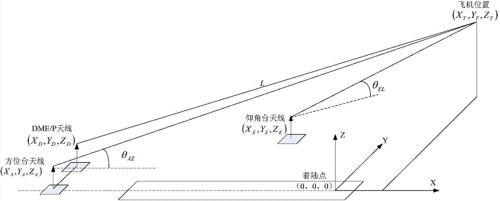
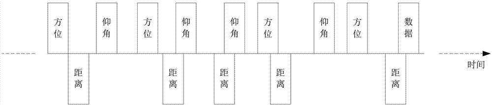
[0037] The basic idea of ​​the present invention is on the basis of the azimuth angle, elevation angle and distance information that airborne equipment records, adopts recursion, interpolation method, respectively calculates and obtains the distance value and the elevation angle value of the aircraft at the azimuth function moment, the azimuth value and the elevation angle value at the elevation angle function moment The distance value, using these position information for coordinate transformation, can avoid the error caused to the aircraft navigation due to the azimuth angle, elevation angle and distance information measured by the airborne equipment are not synchronized, and improve the landing accuracy.

[0038] The processing method of microwave landing angle and rangin...


PUM


Abstract

The invention provides a processing method of microwave landing airborne equipment angle and ranging data. On the basis of azimuth angle, elevation angle and distance information measured by airborne equipment, a recursion and interpolation method is used to respectively calculate the air craft distance value and elevation angle value at an azimuth function moment and the air craft azimuth value and distance value at an elevation angle function moment, coordinate transformation is performed by the position information, air craft navigation errors caused by the asynchronization of the azimuth angle, elevation angle and distance information measured by the airborne equipment are avoided, and landing precision is increased.

Description

technical field [0001] The invention belongs to a microwave landing (Microwave Landing System, MLS) system and is used for data processing of microwave landing airborne equipment angle and distance measurement information. Background technique [0002] The microwave landing system is a kind of precision navigation equipment, which provides real-time and accurate guidance signals for the aircraft. When realizing the precise approach of II and III aircraft, the airborne equipment will measure the azimuth θ AZ , elevation angle θ EL and distance information L are stored on the data bus. When coordinate transformation is performed, the azimuth, elevation angle and distance data before this moment are respectively taken, combined with the position coordinates of the azimuth station antenna, elevation station antenna and DME / P antenna, the aircraft relative to The location of the landing point (X T , Y T ,Z T ),Such as figure 1 shown. Where: Azimuth θ AZ is the angle betwee...

Claims


Application Information

Patent Timeline
IPC IPC(8): G01S7/02
CPCG01S7/02
Inventor 张建明徐飞骆家强郭小伟黄伟
Owner NO 20 RES INST OF CHINA ELECTRONICS TECH GRP
Why Eureka
Try Eureka