Surface mine fine mining system and mining method using gnss technology

A fine and mine technology, applied in mining equipment, surface mining, mining equipment, etc., can solve the problems of over-mining, missed mining, mis-mining at the mining site, etc., and achieve the effect of stabilizing ore grade, avoiding waste, and preventing ore missed mining.

Active Publication Date: 2016-06-29
CHINA NONFERROUS METAL CHANGSHA SURVEY & DESIGN INST CO LTD
View PDF4 Cites 0 Cited by
  • Summary
  • Abstract
  • Description
  • Claims
  • Application Information

AI Technical Summary

Problems solved by technology

[0009] The purpose of the present invention is to provide an open-pit mine fine mining system and mining method using GNSS technology to solve technical problems such as mis-mining, missed mining, and over-mining at the mining site

Method used


Image

  • Surface mine fine mining system and mining method using gnss technology

Examples


Embodiment 1

[0064] Embodiment 1, the basic mining process of the present application.

[0065] A. Built-in mine measurement data in the fine mining location server, the mine measurement data includes the surface digital elevation model (DEM) of the entire mining area and the bioprospecting data of the mining area. Surface depth and ore body thickness information;

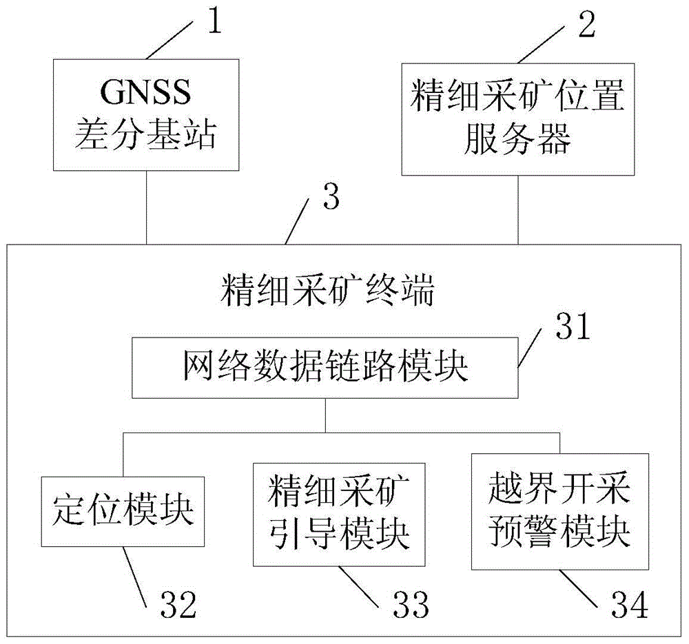
[0066] B. Turn on the fine mining terminal and connect with the GNSS differential base station and the fine mining position server. The fine mining terminal receives the differential correction data from the GNSS differential base station and calculates the position by itself, and sends the accurate bucket position to the fine mining position server;

[0067] C. The fine mining location server receives the bucket position, and sends the bioprospecting data of the mining area at the current location to the fine mining terminal;

[0068] D. The fine mining terminal graphically displays the bioprospecting data of the mining area ...

Embodiment 2

[0070] Embodiment 2, reminding the mining process of boundary information.

[0071] A. Built-in mine measurement data in the fine mining location server, the mine measurement data includes the surface digital elevation model (DEM) of the entire mining area, the bioprospecting data of the mining area and the boundary information agreed by the mining rights, and the bioprospecting data of the mining area includes each location of the mining area ore grade, ore depth from the surface, and ore body thickness information;

[0072] B. Turn on the fine mining terminal and connect with the GNSS differential base station and the fine mining position server. The fine mining terminal receives the differential correction data from the GNSS differential base station and calculates the position by itself, and sends the accurate bucket position to the fine mining position server;

[0073] C. The fine mining location server receives the bucket position, and sends the bioprospecting data of th...

Embodiment 3

[0079] Embodiment 3, the fine mining location server updates the mining process of bioprospecting data in real time.

[0080] A. Built-in mine measurement data in the fine mining location server, the mine measurement data includes the surface digital elevation model (DEM) of the entire mining area and the bioprospecting data of the mining area. Surface depth and ore body thickness information;

[0081] B. Turn on fine mining terminal A and connect with GNSS differential base station and fine mining location server. Fine mining terminal A receives the differential correction data from GNSS differential base station and calculates the position by itself, and sends the accurate bucket A position to the fine mining location server ;

[0082] C. The fine mining location server receives the location of the bucket A, and sends the bioprospecting data of the mining area at the current location to the fine mining terminal A;

[0083] D. Fine mining terminal A graphically displays the...


PUM


Abstract

The invention provides a surface mine fine mining system adopting a GNSS (Global Navigation Satellite System) technology and a surface mine fine mining method. The surface mine fine mining system comprises at least one GNSS difference base station, a fine mining position server and a plurality of fine mining terminals, wherein the fine mining position server is internally provided with mine measurement data; and the fine mining terminals are used for calculating to obtain current positions of fine mining terminal scraper pans according to difference correction data provided by the GNSS difference base station and feeding back scraper pan position information to the fine mining position server. By utilizing the surface mine fine mining system, intuitive ore body thickness / depth / quality information is provided, accurate guidance is provided for mining operation of a digging operator, ore body condition is updated in real time, and the surface mine fine mining system also has the effect of early warning cross-border mining behaviors.

Description

technical field [0001] The present invention relates to the technical field of mineral collection, in particular to an open-pit mine fine mining system and mining method using GNSS (Global Navigation Satellite System, Global Navigation Satellite System) technology. Background technique [0002] The main mining tool in open pit mines is the mining backhoe. The current mining mode is that the mining department formulates mining tasks based on existing prospecting data and measurement data, and delineates mining areas and mining targets every day. Each mining excavator arrives at the mining site to carry out excavation operations according to the previously agreed target. [0003] There are two problems in this mode: First, it is impossible to judge how deep each digging should be, which may easily lead to waste of mineral resources due to missed mining, or a decrease in ore grade due to over-mining. Because as the excavation operation proceeds, the excavator excavation site ...

Claims


Application Information

Patent Timeline
Patent Type & Authority Patents(China)
IPC IPC(8): E21F17/18E21C41/26
CPCE21C41/26E21F17/18
Inventor 金俊杜年春
Owner CHINA NONFERROUS METAL CHANGSHA SURVEY & DESIGN INST CO LTD
Why Eureka
Try Eureka