Information display control method and device for electronic map

An electronic map and information display technology, applied in geographic information databases, maps/plans/charts, electronic digital data processing, etc., can solve problems that affect the efficiency of users' search for target locations, occupy machine resources, and complicate operations, so as to reduce manpower The effect of computer interactive operation, reducing the occupation of machine resources, and improving search efficiency

An electronic map and information display technology, applied in geographic information databases, maps/plans/charts, electronic digital data processing, etc., can solve problems that affect the efficiency of users' search for target locations, occupy machine resources, and complicate operations, so as to reduce manpower The effect of computer interactive operation, reducing the occupation of machine resources, and improving search efficiency

CN104598504AInactive Publication Date: 2015-05-06TENCENT TECH (SHENZHEN) CO LTD

Image

  • Information display control method and device for electronic map
  • Information display control method and device for electronic map
  • Information display control method and device for electronic map

Examples


Embodiment Construction

[0037] The present invention will be further described in detail below in conjunction with the accompanying drawings and specific embodiments.

[0038] In the present invention, the mobile terminal can be a mobile phone, a personal digital assistant (PDA, Personal Digital Assistant), a handheld computer (Pocket PC) or a tablet computer, or a small desktop computer (desktop PC) communicating through the Internet, etc.

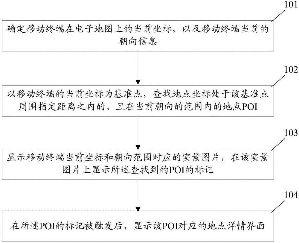
[0039] figure 1 It is a flow chart of the electronic map information display control method of the present invention. see figure 1 , the method includes:

[0040] Step 101. Determine the current coordinates of the mobile terminal on the electronic map and the current orientation information of the mobile terminal.

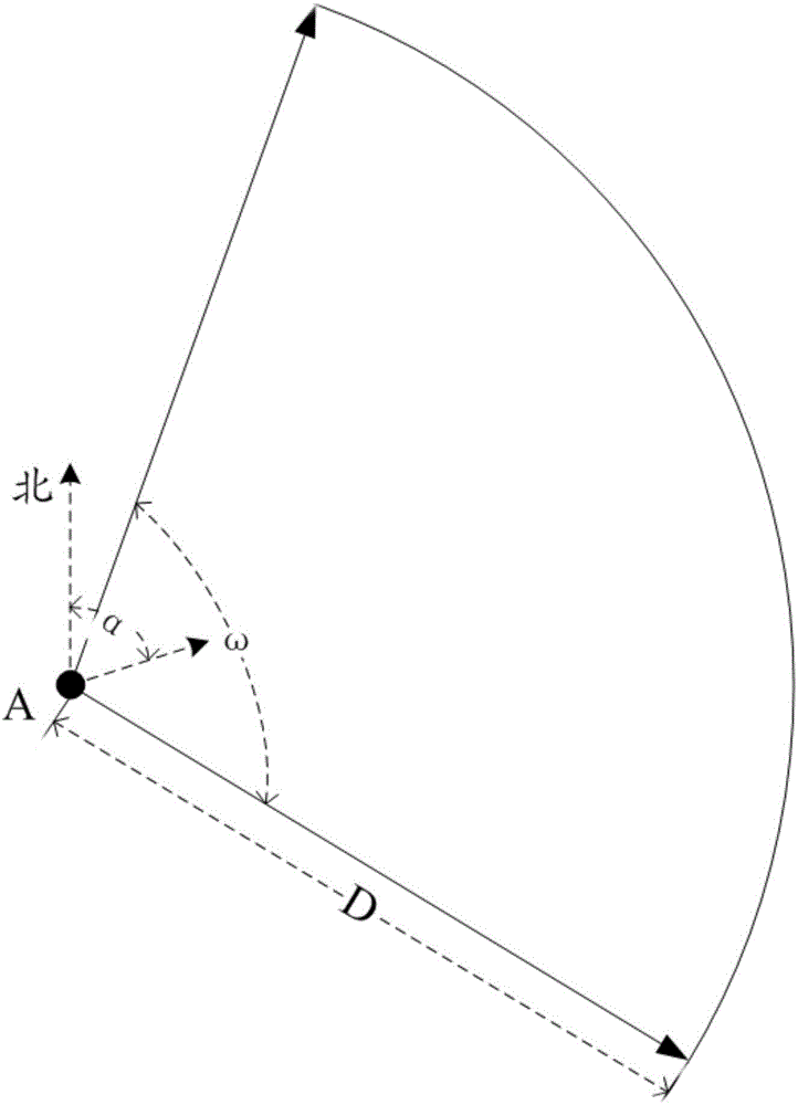
[0041] Step 102: Taking the current coordinates of the mobile terminal as a reference point, search for POIs whose coordinates are within a specified distance around the reference point and within the range of the current orientation.

[0042] St...


PUM


Abstract

The invention discloses an information display control method and device for an electronic map. The method includes the steps that the current coordinates, on the electronic map, of a mobile terminal are determined, and the current orientation information of the mobile terminal is determined; with the current coordinates of the mobile terminal as a datum point, place coordinates, located within the range of specific distance around the datum point and the range of the current orientation, OF a place point of interest (POI) is searched for; a real-scene picture corresponding to the current coordinates and the orientation range of the mobile terminal is displayed, and the mark of the found POI is displayed on the real-scene picture; after the mark of the POI is triggered, a place detail interface corresponding to the POI is displayed. By the utilization of the information display control method and device, the efficiency for searching for a target place can be improved, man-machine interaction operation is reduced, and the occupied machine resources are reduced.

Description

technical field [0001] The present invention relates to the technical field of electronic maps, in particular to an electronic map information display control method and device. Background technique [0002] An electronic map is a digital electronic map, which is an electronic map that is stored and consulted digitally using computer technology. The electronic map can easily combine and splice elements in any form on the content of the ordinary electronic map to form a new electronic map. The method of storing information in electronic maps generally uses vector image storage. The scale of electronic maps can be enlarged, reduced or rotated without affecting the display effect. Current electronic map systems generally use geographic information systems to store and transmit electronic map data. [0003] In the current technical solution of the electronic map system, there is also a street view (Street View) display technology. Street view display technology is a real-scene...

Claims


Application Information

Patent Timeline
06 May 2015
Publication
CN104598504A
IPC
G06F17/30; G09B29/10
CPC
G06F16/29; G09B29/102
Inventors
杜娟