
A Sandstorm Monitoring Method Based on Multi-source Satellite Remote Sensing Data

A technology of satellite remote sensing data and sandstorms, applied in measuring devices, reradiation of electromagnetic waves, radio wave measurement systems, etc., can solve the problems of not being able to meet the needs of all-round sand and dust monitoring and lack of quantitative computing capabilities

Active Publication Date: 2017-04-12
罗敬宁
View PDF2 Cites 0 Cited by
  • Summary
  • Abstract
  • Description
  • Claims
  • Application Information

AI Technical Summary

Problems solved by technology

The above methods can partially solve the problem of dust identification, but they all have obvious limitations, lack of real quantitative computing capabilities, and cannot well meet the needs of all-round sand and dust monitoring

Method used


Image

  • A Sandstorm Monitoring Method Based on Multi-source Satellite Remote Sensing Data
  • A Sandstorm Monitoring Method Based on Multi-source Satellite Remote Sensing Data
  • A Sandstorm Monitoring Method Based on Multi-source Satellite Remote Sensing Data

Examples


Embodiment Construction

[0041] In order to make the purpose, technical solutions and advantages of the embodiments of the present invention more clear, the embodiments of the present invention will be further described in detail below in conjunction with the accompanying drawings. Here, the exemplary embodiments and descriptions of the present invention are used to explain the present invention, but not to limit the present invention.

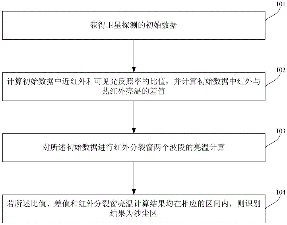
[0042] Such as figure 1 Shown is a flow chart of a sandstorm monitoring method based on satellite remote sensing data according to an embodiment of the present invention.

[0043] Including step 101, obtaining initial data of satellite detection.

[0044] Step 102, calculate the ratio of near-infrared and visible light albedo in the initial data, and calculate the difference in brightness temperature between infrared and thermal infrared in the initial data.

[0045] Step 103, calculate the brightness temperature of the two bands of the infrared split window on the ...


PUM


Abstract

The invention relates to the technical field of atmospheric environment monitoring and particularly relates to a sand storm monitoring method based on multi-source satellite remote sensing data. The sand storm monitoring method for monitoring sand storm more accurately comprises the following steps: obtaining satellite detecting initial data; calculating a ratio of a near-infrared albedo to a visible light albedo in the initial data, and calculating a difference value between an infrared brightness temperature and a thermal infrared brightness temperature in the initial data; performing brightness temperature calculating of two wavebands of an infrared splitting window on the initial data; if the calculated results of the ratio, the difference value and the brightness temperature calculated results of the infrared splitting window are within corresponding regions, indicating the identified results as a sand storm region.

Description

technical field [0001] The invention relates to the technical field of atmospheric environment monitoring, in particular to a sandstorm monitoring method based on multi-distant satellite remote sensing data. Background technique [0002] Sandstorms are a relatively common natural phenomenon caused by special geographical environment and meteorological conditions. They mainly occur in deserts and their adjacent arid and semi-arid areas. North Africa, the Middle East, Central Asia, South Asia, East Asia, North America, and Australia are The world's main sandstorm occurrence areas, the western part of my country is a part of the Central Asian sandstorm area, and the northern part of China is a part of the East Asian sandstorm area. The frequent occurrence of sandstorms is one of the important signs of environmental deterioration. Sandstorms are a meteorological disaster and a serious ecological environment problem. According to the definition of meteorology, sand and dust weath...

Claims


Application Information

Patent Timeline
Patent Type & Authority Patents(China)
IPC IPC(8): G01S17/95
CPCG01W1/00Y02A90/10
Inventor 罗敬宁
Owner 罗敬宁
Learn More