Path planning method and device along hand-drawn route in navigation system

A navigation path and path planning technology, applied in navigation, measuring device, surveying and mapping and navigation, etc., can solve the problems of unstable screen sensitivity, wrong handwritten text recognition, user inconvenience, etc., to solve text input errors and improve interactivity. Effect

Active Publication Date: 2015-06-03
GUANGDONG RITU INFORMATION SYST
View PDF3 Cites 29 Cited by
  • Summary
  • Abstract
  • Description
  • Claims
  • Application Information

AI Technical Summary

Problems solved by technology

[0004] In addition, the existing way of setting the places to pass and avoid places can only be entered in the text input box
In the navigation system, due to the instabilit...

Method used


Image

  • Path planning method and device along hand-drawn route in navigation system
  • Path planning method and device along hand-drawn route in navigation system
  • Path planning method and device along hand-drawn route in navigation system

Examples


Embodiment 1

[0070] Embodiment 1, a path planning device along a hand-drawn route in a navigation system.

[0071] The route planning device along the hand-drawn route in the navigation system in this embodiment includes three modules, namely: a navigation route planning module, a hand-drawn route module and a navigation route re-planning module.

[0072] The navigation path planning module is the traditional navigation path planning module, which can be based on the departure point and destination set by the user (if the user also sets the necessary places and avoidance places, etc., it should also be taken into account), according to the traditional shortest path The search method plans a navigation path.

[0073] If the user is satisfied with the navigation path planned by the navigation path planning module, the path planning ends (the navigation module subsequently guides the planned navigation path). If the user is not satisfied with the navigation path planned by the navigation pat...

Embodiment 2

[0076] Embodiment 2, another device for planning a path along a hand-drawn route in a navigation system.

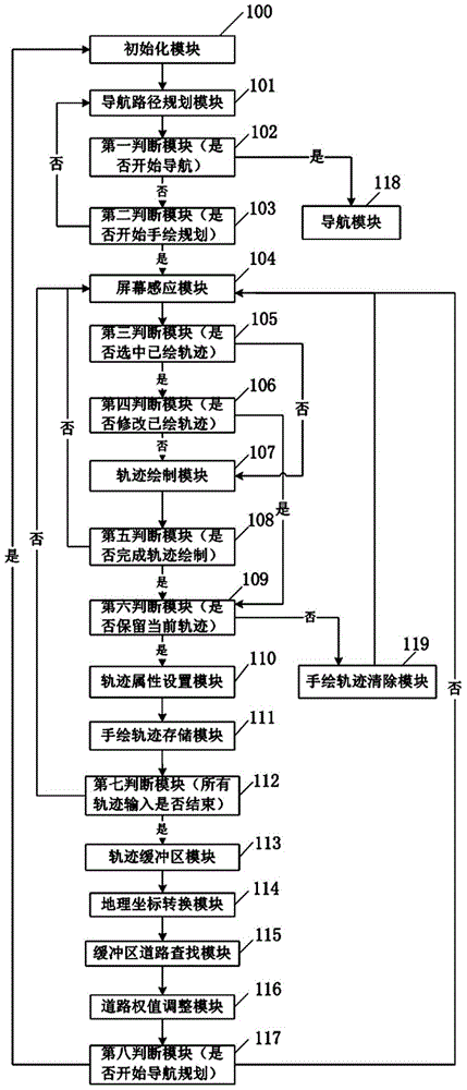
[0077] Such as figure 1 As shown, the path planning device along the hand-drawn route in the navigation system provided by this embodiment includes the following modules: an initialization module 100, a navigation path planning module 101, a first judgment module 102, a second judgment module 103, and a screen sensing module 104 , the third judging module 105, the fourth judging module 106, the trajectory drawing module 107, the fifth judging module 108, the sixth judging module 109, the trajectory attribute setting module 110, the hand-painted trajectory storage module 111, the seventh judging module 112, the trajectory buffer District module 113 , geographic coordinate conversion module 114 , buffer road search module 115 , road weight adjustment module 116 , eighth judging module 117 and hand-painted trajectory clearing module 119 . The functions of each module and th...

Embodiment 3

[0097] Embodiment 3, a path planning method along a hand-drawn route in a navigation system.

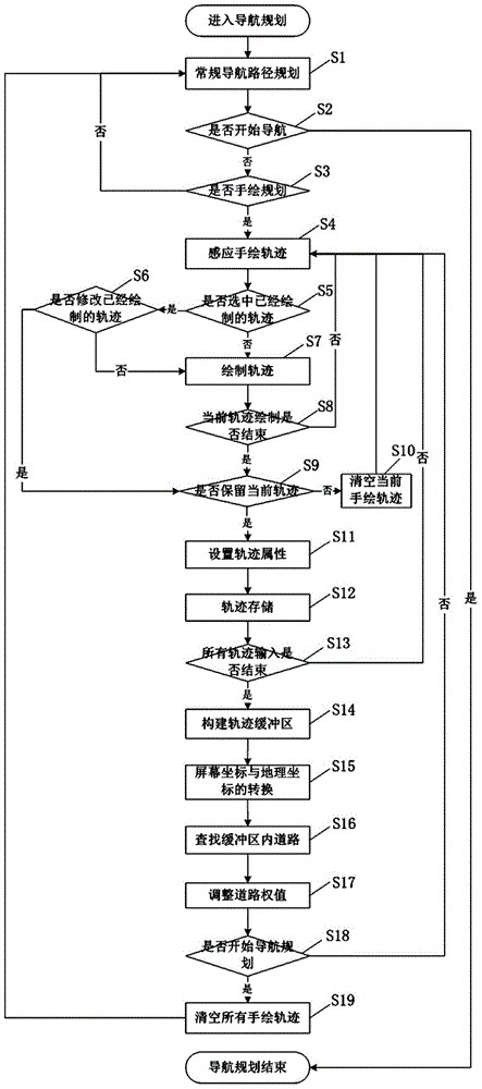
[0098] The path planning method along the hand-drawn route in the navigation system provided by this embodiment includes the following three steps:

[0099] First, plan according to the traditional navigation path, that is, plan a navigation path according to the traditional shortest path search method according to the starting point and destination set by the user (you can also set the necessary places and avoidance places, etc.).

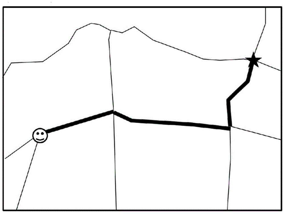
[0100] Second, if the user is not satisfied with the navigation path planned in the first step, draw the hand-drawn trajectory (or hand-drawn route) according to the movement of the user's finger on the touch screen in this step, and then set the preference weight of each hand-drawn trajectory attribute and store. The hand-drawn trajectory in the present invention includes two types of paths, namely, the type of path that the user wishes to drive and th...


PUM


Abstract

The invention relates to a path planning method and a path planning device along a hand-drawn route in a navigation system. The path planning method comprises the following steps: firstly planning a navigation path according to the traditional method and in accordance with departure place and destination set by a user; if the user is dissatisfied for the planned path, drawing the hand-drawn tracks according to the movement of the finger of the user on a touch screen, then setting preference weight attribute of each hand-drawn track and storing the preference weight attribute; next, adjusting the passing capability weight of surrounding roads of each hand-drawn track, and planning a navigation path with largest passing capability according to the adjusted passing capability weight of the roads. The path planning method and the path planning device have the advantages that not only can identification errors generated by inaccuracy of gesture commands inputted by handwriting of the user in the existing navigation system be solved, but also the problem of unreasonable path planning caused by strict way and avoidance of certain interesting points in the existing navigation planning can be solved.

Description

technical field [0001] The invention relates to a path planning method in the technical field of navigation, in particular to a path planning method and device along a hand-drawn route in a navigation system. Background technique [0002] In the current existing map database, each road is preset with its own traffic capacity weight. The navigation system plans a more reasonable navigation path according to the traffic capacity weight of different roads. The user's routine operation is to set the starting point, destination, must-pass and avoid points through the buttons and text input boxes in the touch screen. Based on these settings, the navigation system plans a suitable route for the user's reference. However, this kind of path planning sets some points of interest (POI), which is essentially to calculate the navigation path in segments, and cannot realize more advanced requirements such as specifying the area where the user wants to drive and where the path is to be a...

Claims


Application Information

Patent Timeline
IPC IPC(8): G01C21/34G01C21/36
CPCG01C21/3484G01C21/3617
Inventor 李飞
Owner GUANGDONG RITU INFORMATION SYST
Why Eureka
Try Eureka