Supercharge Your Innovation With Domain-Expert AI Agents!

Automatic positioning method for air vehicle

An automatic positioning and aircraft technology, applied in the directions of instruments, measuring devices, surveying and navigation, etc., can solve the problems of aircraft crashes, dependencies, and strong communication network interference, and achieve the effect of improving positioning reliability and anti-interference.

Inactive Publication Date: 2015-06-17
成都好飞航空技术有限公司
View PDF7 Cites 6 Cited by
  • Summary
  • Abstract
  • Description
  • Claims
  • Application Information

AI Technical Summary

Problems solved by technology

[0003] However, these drones or aircraft must rely on GPS information for positioning
Once the GPS information is wrong or the GPS signal cannot be found or the external interference to the communication network is strong, the operation of the aircraft will fail, and even cause the danger of the aircraft crashing

Method used


Image

  • Automatic positioning method for air vehicle

Examples


Embodiment Construction

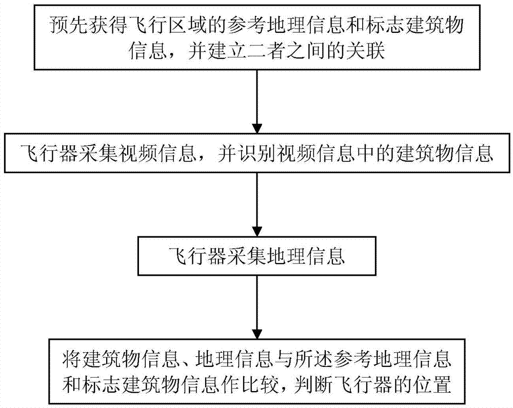
[0021] Such as figure 1 As shown, according to an embodiment of the present invention, the aircraft automatic positioning method includes the following steps:

[0022] (1) Obtain the reference geographic information and landmark building information of the flight area in advance, and establish the association between the two;

[0023] (2) The aircraft collects video information and identifies building information in the video information;

[0024] (3) The aircraft collects geographic information;

[0025] (4) Comparing building information and geographic information with the reference geographic information and landmark building information to determine the position of the aircraft.

[0026] According to a preferred embodiment of the present invention, the reference geographic information includes contour information and map information, and the map information includes layers with GPS information. The landmark building information includes GPS coordinates of the landmark b...


PUM


Abstract

The invention provides an automatic positioning method for an air vehicle to avoid the problem of external electromagnetic interference or GPS signal deficiency. The method comprises the following steps: (1) obtaining referenced geographic information and mark building information of a flight area in advance, and building the correlation between the referenced geographic information and the mark building information; (2) collecting video information by the air vehicle, and recognizing building information in video information; (3) collecting geographic information of the air vehicle; and (4) comparing the building information and the geographic information with the referenced geographic information and mark building information, and judging the position of the air vehicle. According to the automatic positioning method, the dependency on GPS information when the air vehicle, especially an unmanned aerial vehicle executes a task is reduced; and the positioning reliability and the anti-interference performance of the air vehicle are improved.

Description

technical field [0001] The present invention relates to a positioning technology of an unmanned aerial vehicle or an unmanned aerial vehicle, and more particularly, relates to an automatic positioning method of an aircraft. Background technique [0002] The unmanned aerial vehicles used on the market, such as aviation models, toy models, are used for aerial photography, exploration and earthquake relief, etc. to realize flight navigation, all of which are based on manual control and GPS navigation. GPS navigation technology mainly uses the GPS signal receiving module installed on the unmanned aerial vehicle as the GPS signal receiving end, and uses the GPS satellite signal received by it to locate information such as the position and flight speed of the aircraft. [0003] However, these drones or aircraft must rely on GPS information for positioning. Once the GPS information is wrong, or the GPS signal cannot be found, or the external interference to the communication netwo...

Claims


Application Information

Patent Timeline
IPC IPC(8): G01C21/00
CPCG01C21/00
Inventor 仇殿辰
Owner 成都好飞航空技术有限公司
Features
  • R&D
  • Intellectual Property
  • Life Sciences
  • Materials
  • Tech Scout
  • Unparalleled Data Quality
  • Higher Quality Content
  • 60% Fewer Hallucinations
Learn More