A low-altitude light and small infrared and laser radar integrated system

A laser radar and integrated system technology, applied in the field of aerial photogrammetry and remote sensing, can solve the problems of increasing the operation cycle, increasing the time cost of the airborne laser radar measuring instrument, reducing efficiency, etc., achieving efficient acquisition and improving the efficiency of field operations , Improve the effect of point cloud quality

Active Publication Date: 2017-10-03
ZHENGZHOU BANGHAO ELECTRONICS TECH CO LTD
View PDF5 Cites 0 Cited by
  • Summary
  • Abstract
  • Description
  • Claims
  • Application Information

AI Technical Summary

Problems solved by technology

This will undoubtedly increase the time cost of the airborne laser radar measuring instrument, increase the operating cycle and reduce the efficiency

Method used


Image

  • A low-altitude light and small infrared and laser radar integrated system
  • A low-altitude light and small infrared and laser radar integrated system
  • A low-altitude light and small infrared and laser radar integrated system

Examples


Embodiment Construction

[0019] Embodiments of the present invention will be described in detail below in conjunction with the accompanying drawings.

[0020] It should be clear that the described embodiments are only some of the embodiments of the present invention, not all of them. Based on the embodiments of the present invention, all other embodiments obtained by persons of ordinary skill in the art without making creative efforts belong to the protection scope of the present invention.

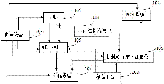
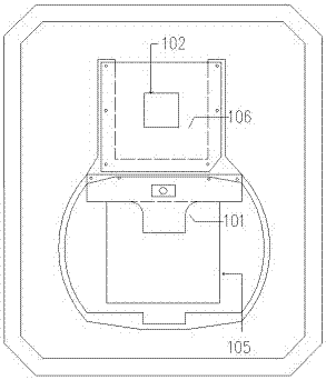
[0021] A low-altitude light and small infrared and laser radar integrated system, such as figure 1 As shown, it includes a motor 101, a POS system 102, a power supply device 103, a flight control system 104, an infrared camera 105, an airborne lidar measuring instrument 106, a storage device 107, a stabilization platform 108 and a flight platform. The POS system 102 is connected with the flight control system 104 , the flight control system 104 is connected with the motor 101 , the infrared camera 105 , and the ...


PUM


Abstract

The invention discloses a low-altitude light and small infrared and laser radar integrated system which comprises a motor, a POS system, a power supply device, a flying control system, an infrared camera, an airborne laser radar measuring instrument, a storage device, a stabilized platform and a flying platform. The POS system is connected with the flying control system, the flying control system is connected with the motor, the infrared camera and the airborne laser radar measuring instrument, and the motor is connected with the infrared camera. The power supply device is connected with the motor, the POS system, the infrared camera, the airborne laser radar measuring instrument and the storage device; the infrared camera and the airborne laser radar measuring instrument are connected with the storage device, and the airborne laser radar measuring instrument is connected with the POS system. The airborne laser scanning measuring instrument, the POS system and the infrared camera are fixed to the stabilized platform. The low-altitude light and small infrared and laser radar integrated system can be applied to the field of aerial photogrammetry and remote sensing, and is not influenced by weather and surroundings, and all-time and all-weather photogrammetry is really achieved.

Description

technical field [0001] The invention relates to aerial photogrammetry and remote sensing technology, in particular to a low-altitude, light and small infrared and laser radar integrated system. Background technique [0002] Thermal infrared is the most widespread radiation in nature. Thermal radiation allows people to clearly observe the surface of the earth at night when there is no light at all. The feature of thermal radiation allows people to use it to measure the temperature and analyze the thermal state of objects without contact throughout the day, providing an important detection technology for resource detection and environmental monitoring. At the same time, the all-weather and all-time nature of thermal imaging will greatly reduce the dependence of aerial photogrammetry on weather. Thermal infrared remote sensing technology has become an important field for countries in the world to demonstrate their scientific and technological strength, promote social and econ...

Claims


Application Information

Patent Timeline
Patent Type & Authority Patents(China)
IPC IPC(8): G01S17/88G01C11/00
CPCG01C11/00G01C11/025G01S17/88
Inventor 李军杰王超张鹏飞杨保王丽媛李世明杨蒙蒙李志杰杜军冯德显郝利民
Owner ZHENGZHOU BANGHAO ELECTRONICS TECH CO LTD
Why Eureka
Try Eureka