Method and system for inverting urban surface temperatures

A surface temperature and city technology, applied in the field of environmental science, can solve problems such as the existence of precision, inconsistent determination methods, and problems, and achieve the effects of low cost, high scope of application, and high precision

Inactive Publication Date: 2015-07-01
BEIJING NORMAL UNIVERSITY
View PDF1 Cites 24 Cited by
  • Summary
  • Abstract
  • Description
  • Claims
  • Application Information

AI Technical Summary

Problems solved by technology

Algorithms for retrieving land surface temperature based on Landsat-5TM remote sensing data in the thermal infrared band currently mainly include radiative transfer equation method, single-window algorithm, universal single-channel algorithm, and image-based algorithm. The accuracy of the three algorithms for surface temperature extraction is controversial, while the image-based algorithm is widely used because of its less dependence on atmospheric parameters
However, due to the inconsistency in determining the emissivity of the surface, there are some problems in the accuracy of the image-based algorithm when extracting the surface temperature.

Method used


Image

  • Method and system for inverting urban surface temperatures
  • Method and system for inverting urban surface temperatures
  • Method and system for inverting urban surface temperatures

Examples


Embodiment Construction

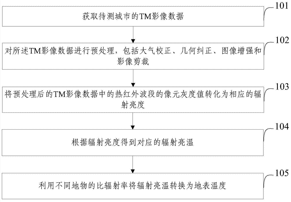
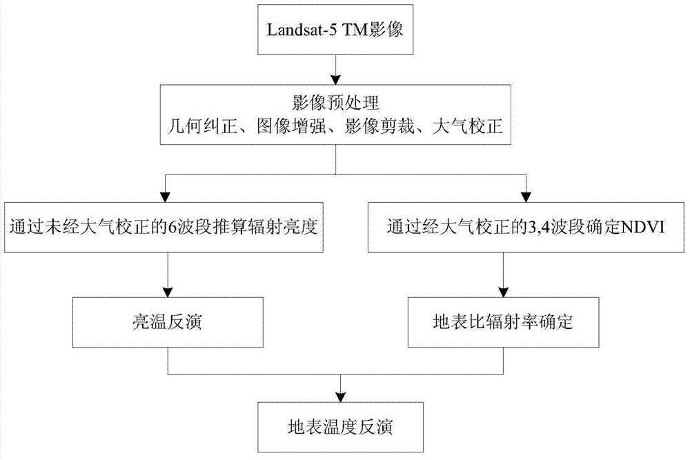
[0052]In order to make the purpose, technical solutions and advantages of the embodiments of the present invention clearer, the technical solutions in the embodiments of the present invention will be clearly and completely described below in conjunction with the drawings in the embodiments of the present invention. Obviously, the described embodiments It is a part of embodiments of the present invention, but not all embodiments. Based on the embodiments of the present invention, all other embodiments obtained by persons of ordinary skill in the art without creative efforts fall within the protection scope of the present invention.

[0053] With the development of the basic theory and technology of remote sensing, the technology of retrieving land surface temperature using satellite sensors with thermal infrared channels has been widely used in recent years. At present, the remote sensing data used to obtain surface temperature mainly include NOAA AVHRR, MODIS, Landsat-5TM, AST...


PUM


Abstract

The invention provides a method and a system for inverting urban surface temperatures. The method comprises the steps of S1, obtaining the TM image data of a region to be tested, S2, preprocessing the TM image data, including atmospheric correction, geometric correction, image enhancement and image clipping, S3, converting the pixel gray level value of the thermal infrared band in the preprocessed TM image data into corresponding radiance, S4, obtaining corresponding a radiation brightness temperature according to the radiance, and S5, converting the radiation brightness temperature into the surface temperature by use of the emissivity of different surface features, wherein the TM image data are multi-band scanning image data obtained by use of an optical earth land satellite Landsat-5 thematic charting instrument TM. The method can be widely applied to monitoring the urban thermal environment, and has the advantages of low cost, high accuracy and wide application range.

Description

technical field [0001] The invention relates to the field of environmental science, in particular to a method and system for retrieving urban surface temperature. Background technique [0002] Since the 1990s, my country has entered a stage of accelerated urbanization, which has led to a surge in urban high-rise buildings, motor vehicles, and man-made heat sources, as well as a huge change in the nature of urban land. These factors have jointly led to urban heat islands, air pollution, and ecological imbalance. and many other environmental issues. Among them, the deterioration of the urban thermal environment represented by the heat island effect has become an important factor affecting the urban ecological environment, and has seriously restricted the quality of the urban living environment. Urban Land Surface Temperature (LST) is an important geophysical parameter that plays an important role in monitoring the heat island effect that affects the comfort of urban life, and ...

Claims


Application Information

Patent Timeline
Patent Type & Authority Applications(China)
IPC IPC(8): G01J5/00G01S17/89
Inventor 张力小田光进庞明月葛荣凤
Owner BEIJING NORMAL UNIVERSITY
Why Eureka
Try Eureka