Concave convex mixed complex polygon farmland unmanned aerial vehicle spraying operation flight path planning method

A track planning, polygonal technology, applied in two-dimensional position/channel control and other directions, can solve the problems of low fuel consumption, short time, inappropriate pesticide spraying operations, etc., to reduce energy consumption, reduce complexity and improve spraying. The effect of efficiency

Active Publication Date: 2015-07-29
CENT SOUTH UNIV
View PDF6 Cites 91 Cited by
  • Summary
  • Abstract
  • Description
  • Claims
  • Application Information

AI Technical Summary

Problems solved by technology

[0006] Traditional heuristic search and other path search methods have their own advantages in dealing with the shortest reachable path, the best flight path (short time, low fuel consumption, high safety), avoiding obstacles, etc., but they are not applicable The trajectory planning of pesticide spraying operations in farmland is determined by the particularity of farmland operations. Different from the traditional shortest flight path; b) On the basis of satisfying the full

Method used


Image

  • Concave convex mixed complex polygon farmland unmanned aerial vehicle spraying operation flight path planning method
  • Concave convex mixed complex polygon farmland unmanned aerial vehicle spraying operation flight path planning method
  • Concave convex mixed complex polygon farmland unmanned aerial vehicle spraying operation flight path planning method

Examples


Embodiment Construction

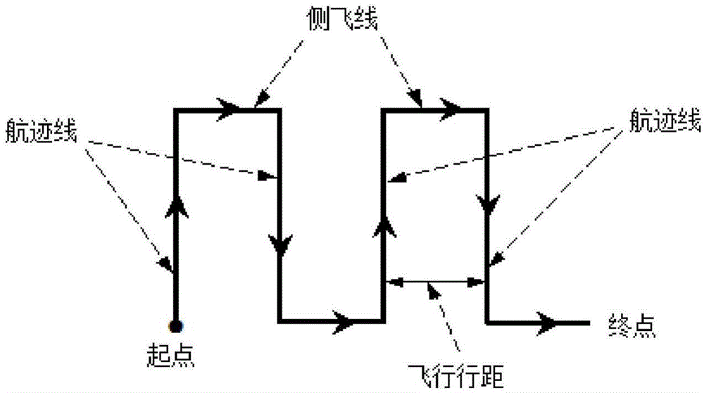
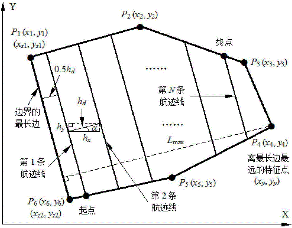
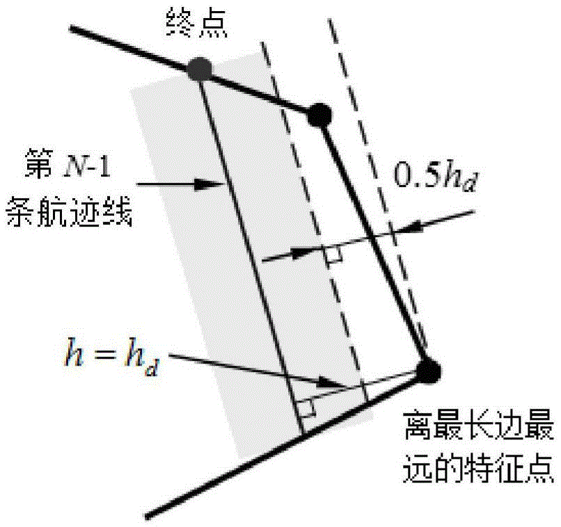
[0039] The main task of the present invention is to determine one group of track lines (the track line is from the longest side of the polygon to the farthest feature point on the other side of the farmland area boundary opposite to the longest side, parallel to the longest side A group of equally spaced parallel lines, the width of the interval is set as the flight distance), and the intersection point of this group of flight path lines and the concave-convex mixed polygonal farmland boundary is calculated. The main steps of its realization are: (1) Use a handheld GPS positioning device to collect the latitude and longitude coordinates of all the feature points (key location points) on the border of the farmland operation area and send these coordinate information to a tablet computer (it is an unmanned helicopter). Flying monitoring and management equipment), the tablet computer connects two adjacent points with a straight line according to the order of these feature points, ...


PUM


Abstract

The invention discloses a concave convex mixed complex polygon farmland unmanned aerial vehicle spraying operation flight path planning method. Starting from any feature point on the boundary of the polygon farmland, all feature points of the boundary of the polygon farmland are acquired sequentially, adjacent two points are connected by using a straight line sequentially according to the point acquisition sequence of the feature points, and an operation region of the boundary of the polygon farmland is generated; the longest edge of the boundary of the operation region is found out; a feature point farthest from the longest edge is found out; N flight path lines are drawn between the longest edge and the feature point farthest from the longest edge; coordinates of all boundary line segments crossed with the flight path lines and flight path line crossed points are obtained; the number of the crossed points between the flight path lines and the boundary line segments is judged, and when the number of the crossed points is larger than 2, flight path lines outside the operation region range are deleted; and starting from a flight path line nearest to the longest edge, the flight path lines and side flight lines are connected in sequence, and an S-shaped flight path planning line is obtained. The flight path of the concave convex mixed complex polygon farmland unmanned aerial vehicle spraying operation can be planned.

Description

technical field [0001] The invention relates to the field of track planning for unmanned helicopters, in particular to a track planning method for unmanned aerial vehicle spraying operations in farmland with concave-convex mixed complex polygons. Background technique [0002] With the advancement of science, technology and society, agricultural modernization has become an irreversible development trend, especially for a large agricultural country like ours, agricultural modernization is an extremely important way to improve social productivity. The idea of ​​modern agriculture in the three rural issues also greatly reflects the urgent need for modern agriculture in our country. Especially for field operations such as pesticide spraying, which are labor-intensive and can cause harm to the human body, using science and technology and modern equipment to reduce the labor burden of farmers is an important goal pursued by modern agriculture. [0003] Under the existing condition...

Claims


Application Information

Patent Timeline
IPC IPC(8): G05D1/02
Inventor 谭冠政于小民谭淦谭冠军
Owner CENT SOUTH UNIV
Why Eureka
Try Eureka