Method and system for generating flood risk map

A flood risk map and flood technology, applied in the directions of maps/plans/charts, special data processing applications, instruments, etc., can solve the problems of increasing errors in static flood risk maps, difficulty in static flood risk maps, and lack of historical experience data. , to achieve the effect of improving real-time and accuracy, improving update frequency and update speed, and accurate flood risk information

Active Publication Date: 2015-08-19
浙江贵仁信息科技股份有限公司
View PDF5 Cites 42 Cited by
  • Summary
  • Abstract
  • Description
  • Claims
  • Application Information

AI Technical Summary

Problems solved by technology

Therefore, historical flood outbreaks are often not representative of future flood characteristics, resulting in increased errors in static flood risk maps
[0007] In addition, in economically backward areas, general historical experience data is relatively scarce, and it is difficult to draw a static flood risk map
[0008] Moreover, the current static flood risk map often only considers a single factor for a specific service object, resulting in certain limitations and one-sidedness in the drawn static flood risk map, making it less shared among different industries

Method used


Image

  • Method and system for generating flood risk map
  • Method and system for generating flood risk map
  • Method and system for generating flood risk map

Examples


Embodiment Construction

[0083] Exemplary embodiments of the present disclosure will be described in more detail below with reference to the accompanying drawings. Although exemplary embodiments of the present disclosure are shown in the drawings, it should be understood that the present disclosure may be embodied in various forms and should not be limited to the embodiments set forth herein. Rather, these embodiments are provided for more thorough understanding of the present disclosure and to fully convey the scope of the present disclosure to those skilled in the art.

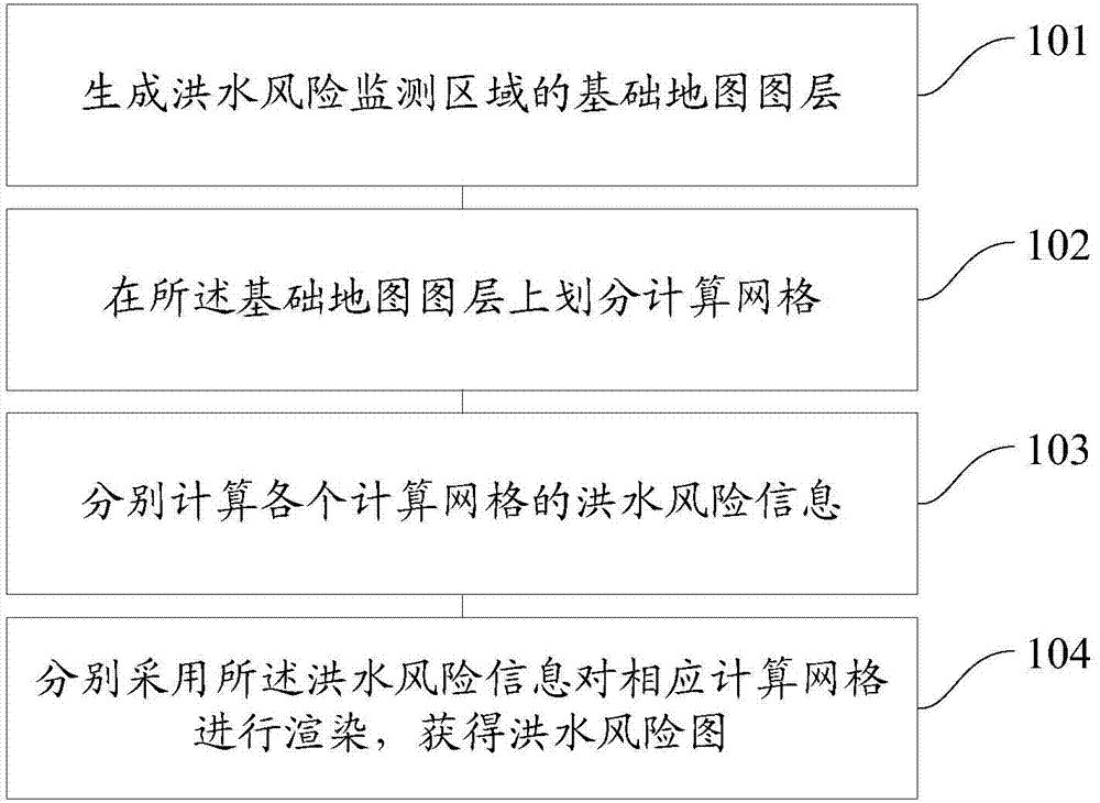
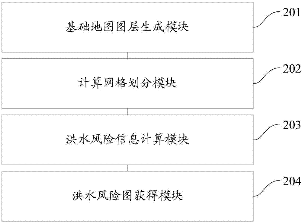
[0084] One of the core ideas of the embodiment of the present application is to propose a generation mechanism of flood risk map, which can render and generate the flood risk map by calculating the flood risk information in the divided computing grid, so as to realize the simulation and prediction of historical flood frequency, And / or, the flood risk map formed under future flood outbreaks can improve the real-time and accuracy of f...


PUM


Abstract

The invention discloses a method and system for generating a flood risk map, and the method comprises the steps: generating a basic map layer of a flood risk monitoring region; forming computational grids through dividing on the basic map layer; respectively calculating the flood risk information of each computational grid; respectively rendering each computational grid through the corresponding flood risk information, and obtaining the flood risk map. The method simulates and predicts the frequency of historical flood, and / or the flood risk map formed during the occurrence of future flood, thereby improving the instantaneity and accuracy of the drawing of the flood risk map, improving the updating frequency and speed of the flood risk map, reducing the generation difficulty of the flood risk map, and improving the sharing of the flood risk map among different industries.

Description

technical field [0001] This application relates to the technical field of water conservancy GIS mapping, in particular to a method for generating a flood risk map and a system for generating a flood risk map. Background technique [0002] The losses caused by flood disasters can be divided into tangible losses and intangible losses. Tangible losses refer to losses that can be measured by economic indicators, while intangible losses refer to losses that cannot be measured by economic indicators. Intangible losses are difficult to accurately evaluate. According to the time characteristics of flood occurrence and development, tangible losses can be divided into direct losses and indirect losses. Direct loss refers to the loss caused by direct contact with floods, such as the destruction of buildings, the submersion of crops, etc.; indirect loss refers to the loss caused by the interruption or destruction of certain relationships in the natural environment or social and economic...

Claims


Application Information

Patent Timeline
Patent Type & Authority Applications(China)
IPC IPC(8): G09B29/00G06F19/00
CPCG09B29/007G16Z99/00
Inventor 桂发二
Owner 浙江贵仁信息科技股份有限公司
Why Eureka
Try Eureka