Mobile phone-based indoor geomagnetic navigation method and apparatus thereof

A geomagnetic navigation and geomagnetic technology, which is applied to ground navigation, navigation, measuring devices, etc., can solve problems that affect navigation accuracy and numerical mismatches, and achieve the effect of improving accuracy and improving accuracy

Inactive Publication Date: 2015-09-09
中测高科(北京)测绘工程技术有限责任公司
View PDF7 Cites 29 Cited by
  • Summary
  • Abstract
  • Description
  • Claims
  • Application Information

AI Technical Summary

Problems solved by technology

[0005] The invention provides an indoor geomagnetic navigation method based on a mobile phone, which solves the technical problem that in the prior art, mobile phones of different brands and models are prone to mismatching values ​​during navigation and affect navigation accuracy

Method used


Image

  • Mobile phone-based indoor geomagnetic navigation method and apparatus thereof
  • Mobile phone-based indoor geomagnetic navigation method and apparatus thereof
  • Mobile phone-based indoor geomagnetic navigation method and apparatus thereof

Examples


Embodiment Construction

[0019] In order to make the above objects, features and advantages of the present invention more comprehensible, the present invention will be further described in detail below in conjunction with the accompanying drawings and specific embodiments.

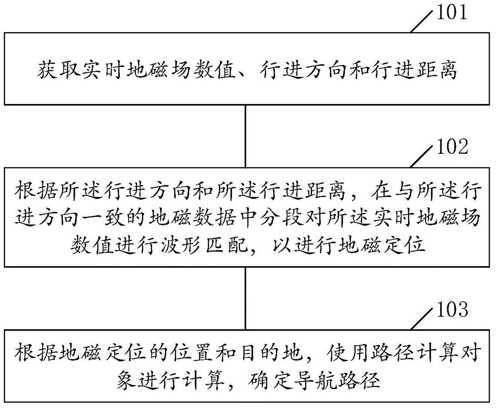
[0020] Such as figure 1 Provide a flow chart of a mobile phone-based indoor geomagnetic navigation method in an embodiment of the present invention, including:

[0021] Step 101, obtaining real-time geomagnetic field value, traveling direction and traveling distance;

[0022] Among them, the user walks a certain distance to collect a certain amount of geomagnetic sensor data, accelerometer data and gyroscope data. After processing and correcting the above sensor data, a multi-element vector is obtained, including the total geomagnetic field (F), three geomagnetic components (X, Y, Z), traveling direction (A) and traveling distance (L1). These data are obtained by Accelerometer sensor, gyroscope sensor and magnetic field sensor a...


PUM


Abstract

The invention relates to the field of indoor geomagnetic navigation, and discloses a mobile phone-based indoor geomagnetic navigation method and an apparatus thereof. The method comprises the following steps: obtaining the real-time geomagnetic value, the traveling direction and the traveling distance, carrying out waveform matching on the real-time geomagnetic value in a sectional manner in geomagnetic data consistent with the traveling direction according to the traveling direction and the traveling distance in order to realize geomagnetic positioning, and calculating a path calculating object according to the position and destination of the geomagnetic positioning to determine a navigation path. The method and the apparatus improve the accuracy of the geomagnetic positioning, and improve the precision of geomagnetic navigation.

Description

technical field [0001] The invention relates to the field of indoor geomagnetic navigation, in particular to an indoor geomagnetic navigation method and device based on a mobile phone. Background technique [0002] Satellite navigation devices such as GPS and Beidou have been widely used in all aspects of society, and their positioning accuracy has also been recognized by people. However, satellite signals are easily blocked by objects such as trees and buildings, resulting in equipment not being able to find satellite signals. Unable to navigate. [0003] With the maturity of semiconductor technology and microchip technology, more and more sensors are integrated on mobile phones, including gyroscopes, magnetic field sensors, accelerometers, Bluetooth, wireless network cards, etc., and the functions of these sensors are gradually being used. From network downloads, to data transmission, to mobile games based on multiple sensors, to emerging indoor navigation. Different ind...

Claims


Application Information

Patent Timeline
Patent Type & Authority Applications(China)
IPC IPC(8): G01C21/08G01C21/20
CPCG01C21/08G01C21/206
Inventor 范荣双张巍陈丽房慎冲吴朋朋景新超
Owner 中测高科(北京)测绘工程技术有限责任公司
Why Eureka
Try Eureka