
Event spatio-temporal data analysis method based on GIS map

A GIS map, spatiotemporal data technology, applied in electrical digital data processing, special data processing applications, instruments, etc., can solve problems such as application depth enhancement, lack of analysis of time factors, non-occurrence, etc., to improve analysis and reduce incidents. Possibilities, spatiotemporal analysis show intuitive and effective effects

Inactive Publication Date: 2015-09-09
SUZHOU IND PARK GEONE INFORMATION TECH CO LTD
View PDF4 Cites 9 Cited by
  • Summary
  • Abstract
  • Description
  • Claims
  • Application Information

AI Technical Summary

Problems solved by technology

[0003] With the promotion of GIS tools, the spatial analysis technology is now very mature, but the strengthening of application depth has gradually revealed its defects, the most important of which is the relative lack of analysis of time factors
In the application fields of GIS, such as transportation, urban management, planning, construction, national land, etc., the time characteristics of spatial objects are very obvious and have strong regularity in combination with spatial characteristics. Analysis poses a greater challenge, but in view of the particularity of business in various fields and the high requirements for data collection, although there are related temporal GIS models, they are still in the research and exploration stage, and applications combined with specific industries have not yet appeared

Method used


Image

  • Event spatio-temporal data analysis method based on GIS map
  • Event spatio-temporal data analysis method based on GIS map

Examples


Embodiment Construction

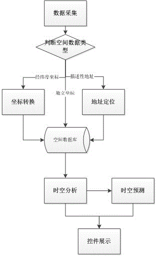
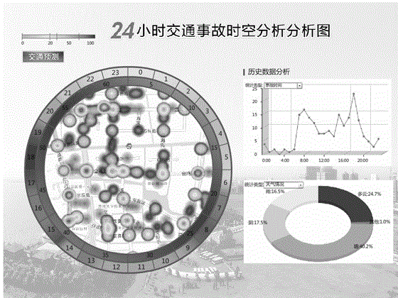
[0014] Such as figure 1 , figure 2 The shown method for analyzing event spatio-temporal data based on GIS map is characterized in that it includes the following steps: First, collect event data. After that, spatially locate the data in step ①. Next, perform spatio-temporal analysis on the processed data in step ②. Subsequently, spatiotemporal prediction is performed on the data processed in step ③. Finally, data display can be performed through corresponding controls. In order to improve data loading capabilities and facilitate users to analyze event spatio-temporal data, the data at least includes spatio-temporal data, and the spatio-temporal data includes time information, coordinate information, spatial object information and / or address description information.

[0015] As far as a preferred embodiment of the present invention is concerned, in order to facilitate subsequent analysis and combine various necessary data with events as much as possible, event data collecti...


PUM


Abstract

The invention relates to an event spatio-temporal data analysis method based on a GIS map. The event spatio-temporal data analysis method has the characteristics of firstly, acquiring event data and then performing space positioning on the data; then performing spatio-temporal analysis on the data; immediately, performing spatio-temporal prediction on the processed data; and finally performing data display by a corresponding control. Therefore, by depending on combination of the GIS map and the event spatio-temporal data and effectively carrying out displaying through a control, a rectangular displaying mode of a conventional map space is broken through. Meanwhile, by changing the map into round display and peripherally adding multi-span time display, a spatio-temporal linkage effect is realized. In addition, the spatio-temporal analysis and display of geographic objects are more intuitive and effective by integrating an existing chart display mode. Therefore, by the method disclosed by the invention, analysis on event data can be improved, prediction analysis is performed during statistics, and occurring possibility of subsequent events is reduced.

Description

technical field [0001] The invention relates to an event time-space data analysis method, in particular to a GIS map-based event time-space data analysis method. Background technique [0002] Geographic Information System (GIS for short), as an important tool and technology for acquiring, processing, managing and analyzing geospatial data, has received extensive attention and rapid development in recent years. From the perspective of technology and application, GIS is a tool, method and technology to solve spatial problems. From a functional point of view, GIS has the functions of acquiring, storing, displaying, editing, processing and analyzing spatial data. Spatial analysis is an important function and feature of GIS. It conducts data analysis and mining based on the location and shape of geographic objects, and mines potential spatial information through geographic calculation and spatial expression, including spatial information measurement, spatial information classific...

Claims


Application Information

Patent Timeline
Patent Type & Authority Applications(China)
IPC IPC(8): G06F17/30
Inventor 林玉峰
Owner SUZHOU IND PARK GEONE INFORMATION TECH CO LTD
Learn More