
Unmanned aerial vehicle-based closed fire scene heat source location method

A positioning method and unmanned aerial vehicle technology, applied in fire alarms and closed-circuit television systems that rely on radiation, can solve problems such as mistakes, and achieve the effect of reducing danger and facilitating rescue work.

Inactive Publication Date: 2015-09-16
CHINA JILIANG UNIV
View PDF6 Cites 24 Cited by
  • Summary
  • Abstract
  • Description
  • Claims
  • Application Information

AI Technical Summary

Problems solved by technology

[0004] At present, when a fire breaks out in a closed building such as a warehouse, firefighters rely on the drawings of the building, the information in the building dictated by relevant personnel, and the fireworks observed from doors and windows to judge the fire and the distribution of heat sources in the building. This method has played a vital role in many fire rescues, but there will also be mistakes, so now there is an urgent need for a method that can accurately find the heat source of a closed fire scene in the shortest time

Method used


Image

  • Unmanned aerial vehicle-based closed fire scene heat source location method
  • Unmanned aerial vehicle-based closed fire scene heat source location method

Examples


Embodiment Construction

[0025] Hereinafter, preferred examples of the present invention will be described in detail with reference to the accompanying drawings. It should be understood that the preferred embodiments are only for illustrating the present invention, but not for limiting the protection scope of the present invention.

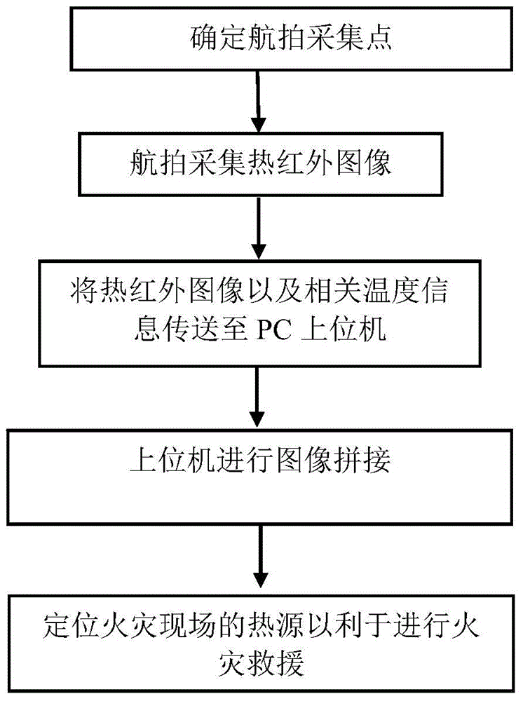
[0026] Such as figure 1 As shown, the present invention firstly plans the aerial photographing plan of the walls and the roof of the front, rear, left and right four walls and the roof of the closed fire scene periphery by unmanned aerial vehicle after surveying the periphery of the closed fire scene; secondly, carrying The infrared thermal imager and the drone of the aerial photography equipment carry out aerial photography according to the preset aerial photography route and shooting plan, and upload the pictures and temperature data taken by the infrared thermal imager to the host computer; finally, the host computer passes the image splicing The technology stitches t...


PUM


Abstract

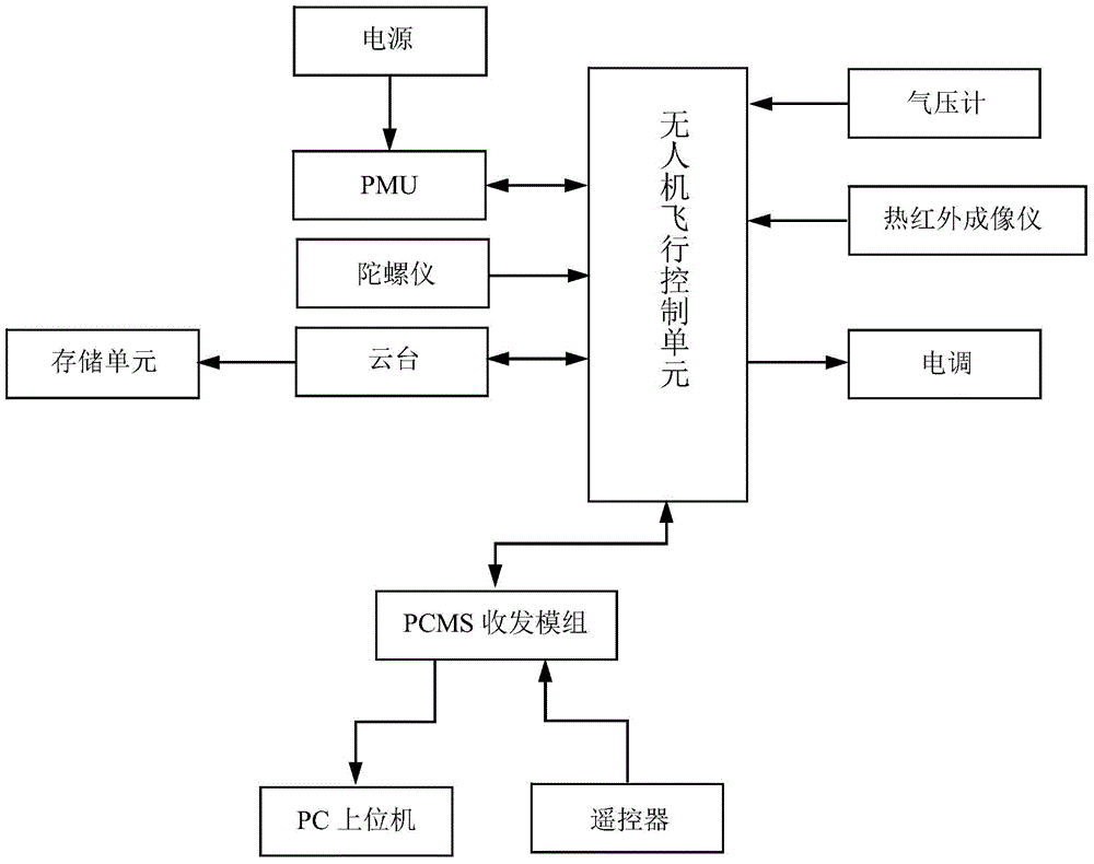
The invention discloses an unmanned aerial vehicle-based closed fire scene heat source location method. The unmanned aerial vehicle-based closed fire scene heat source location method includes the following steps that: a system comprising an unmanned aerial vehicle and an infrared thermal imaging instrument is adopted; the unmanned aerial vehicle performs aerial photography on the surrounding bounding walls and roof of a building on a fire scene in an automatic cruise mode or a flight manual control mode so as to acquire thermal infrared images and upload the thermal infrared images to a PC; the thermal infrared images are spliced, so that thermal infrared images of the surrounding bounding walls of the building on the fire scene and thermal infrared images of the roof of the building on the fire scene can be obtained; and a position which is most adjacent to a fire source can be judged and determined through temperature data on five thermal infrared images, and therefore, the location of the heat source can be realized. With the unmanned aerial vehicle-based closed fire scene heat source location method adopted, risks in a situation in which firefighters enter the fire scene can be decreased, and the internal situation of the fire scene can be mastered more quickly and more effectively, and conveniences can be provided for rescue work, and s defect that no method in which an unmanned aerial vehicle performs aerial photography to find a heat source does not exist in closed fire scene heat source finding methods in the prior art can be eliminated.

Description

technical field [0001] The invention relates to a method for finding a heat source at a fire scene, in particular to a method for locating a heat source at a closed fire scene based on an unmanned aerial vehicle. Background technique [0002] Fire refers to the disaster caused by burning out of control in time or space. Among various disasters, fire is one of the main disasters that most often and most commonly threaten public safety and social development. [0003] The three elements that cause a fire are combustibles, combustibles, and heat sources. Generally, combustibles are paper, wood, cotton and other combustible objects. There are often a large number of combustibles at the scene of a fire; combustibles refer to The substances that help combustibles burn, to be precise, refer to substances that can react with combustible substances. The most common combustion-supporting substances in the combustion process are oxygen contained in the air, and there are also some chem...

Claims


Application Information

Patent Timeline
Patent Type & Authority Applications(China)
IPC IPC(8): H04N7/18G08B17/12
Inventor 郑恩辉冯逸骅高坚洪忠豪孙坚
Owner CHINA JILIANG UNIV
Learn More