Comprehensive monitoring and early warning system based on meteorology and power grid GIS and method thereof

A comprehensive monitoring and early warning system technology, applied in meteorology, measurement devices, ICT adaptation, etc., can solve the problems of lack of guidance or templates, lack of system support, standardization of emergency management, and low level of digitization, so as to reduce social impact, The effect of reducing disaster losses

Inactive Publication Date: 2015-09-30
EMERGENCY MANAGEMENT CENT OF STATE GRID SHANDONG ELECTRIC POWER
View PDF6 Cites 69 Cited by
  • Summary
  • Abstract
  • Description
  • Claims
  • Application Information

AI Technical Summary

Problems solved by technology

[0005] (1) Power grid operation information and equipment status information cannot be displayed, monitored, analyzed, warned, and responded in real time
In particular, the comprehensive analysis ability and scientific processing technology for a large number of information need to be improved, and it is impossible to accurately and effectively predict and analyze the hidden dangers of the power grid and formulate plans
[0006] (2) Standardization and digitalization of emergency management is not high
The classification, level, impact, and content description terms of emergencies are not standardized. As a result, when emergency departments at all levels report emergencies, they lack clear guidance or templates, cannot be quickly retrieved and applied, and affect the efficiency of emergency handling. Facilitate the analysis and handling of emergencies in the later stage
[0007] (3) No access to social public information resources: such as transportation, meteorology, geology, water conservancy, municipal administration, public opinion media, etc., and no information exchange with government emergency departments and electricity supervision departments
[0008] (4) There is a lack of system support for monitoring, analysis, early warning, response, and post-disposal before emergencies occur, and corresponding system development is required

Method used


Image

  • Comprehensive monitoring and early warning system based on meteorology and power grid GIS and method thereof
  • Comprehensive monitoring and early warning system based on meteorology and power grid GIS and method thereof

Examples


Embodiment Construction

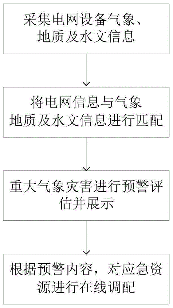
[0054] Below in conjunction with accompanying drawing and embodiment the present invention will be further described:

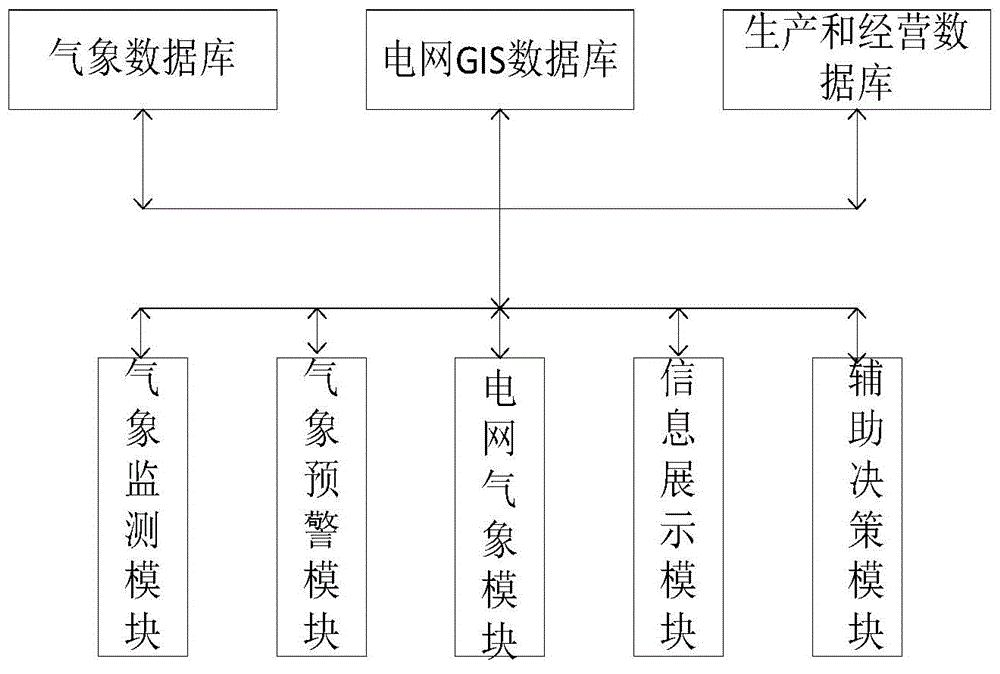
[0055] Such as figure 1 As shown, the comprehensive monitoring and early warning system based on power grid meteorological disasters includes: data layer and application layer;

[0056] The data layer includes: meteorological database, power grid GIS database, production and operation database; meteorological database is mainly used to store real-time meteorological, geological and hydrological information; power grid GIS database is mainly used to store power grid lines and power grid equipment information; It is used to store the deployment and scheduling information of emergency resources. The three databases communicate with each other to realize the interaction of different data.

[0057] The application layer includes:

[0058] Meteorological monitoring module: used for real-time monitoring of meteorological information, geological and hydrological i...


PUM


Abstract

The invention discloses a comprehensive monitoring and early warning system based on meteorology and a power grid GIS and a method thereof. The system comprises a data layer and an application layer. The data layer consists of a meteorological database, a power grid GIS database, and a production and operation database. The application layer includes a meteorological monitoring module, a meteorological early warning module, a power grid weather module, an information display module, and an auxiliary decision-making module. The meteorological database, the power grid GIS database, and the production and operation database carry out communication mutually; and the meteorological monitoring module, the meteorological early warning module, the power grid weather module, the information display module, and the auxiliary decision-making module carry out communication with the meteorological database, the power grid GIS database, and the production and operation database respectively. According to the invention, meteorological monitoring information like the temperature, wind direction, and wind speed and the like of important power equipment like a transformer substation, a transmission and transformation line, and a tower can be gotten in real time; and visual meteorological real-time data can be provided for the power grid. Meanwhile, prediction and disaster early warning information of the typhoon and thunder and the like can be provided every 12 hours in the next seven days.

Description

technical field [0001] The invention belongs to the field of meteorological early warning of electric power systems, and in particular relates to a comprehensive monitoring and early warning system and method based on meteorological and power grid GIS. Background technique [0002] The disastrous weather monitoring and early warning capabilities of meteorological departments have developed rapidly, and advanced modern observation and detection equipment such as high-temporal and spatial-resolution meteorological element observation stations, Doppler weather radars, and FY2E / F meteorological satellites have gradually realized automatic and intelligent upgrades , and has achieved stable network operation for many years. The RUC (Rapid Update Cycle) system based on three-dimensional variational assimilation and the mesoscale analysis technology of strong convective weather have been established successively, providing strong meteorological technical support for the meteorologic...

Claims


Application Information

Patent Timeline
Patent Type & Authority Applications(China)
IPC IPC(8): G06Q50/06G01W1/02
CPCY02A50/00Y02A90/10
Inventor 李同智李红梅孙世军韩洪王勇张治取孙为民杨啸帅王波张鹏程中华
Owner EMERGENCY MANAGEMENT CENT OF STATE GRID SHANDONG ELECTRIC POWER
Why Eureka
Try Eureka