Unmanned plane cruise method and apparatus thereof

A technology for drones and routes, applied in measurement devices, navigation, mapping and navigation, etc., can solve the problems of large precision error, low degree of automation, and delay in manually drawing routes, and achieve the effect of improving flexibility.

Active Publication Date: 2015-11-11
SICHUAN AEE AVIATION TECH CO LTD
View PDF6 Cites 14 Cited by
  • Summary
  • Abstract
  • Description
  • Claims
  • Application Information

AI Technical Summary

Problems solved by technology

[0003] At present, the automatic flight of UAVs is based on the routes drawn manually in advance to perform flight tasks, and manual drawing of routes will delay a certain amount of time when actually performing emergency flight tasks
In addition, there is a large accuracy error in the manual judgment of the map. It is troublesome to execute the mission and change the mission after drawing the route for the first time to save the mission. If you want to complete a mission that is different from the previous flight, you must redraw and reroute, so less automation

Method used


Image

  • Unmanned plane cruise method and apparatus thereof
  • Unmanned plane cruise method and apparatus thereof
  • Unmanned plane cruise method and apparatus thereof

Examples


no. 1 example

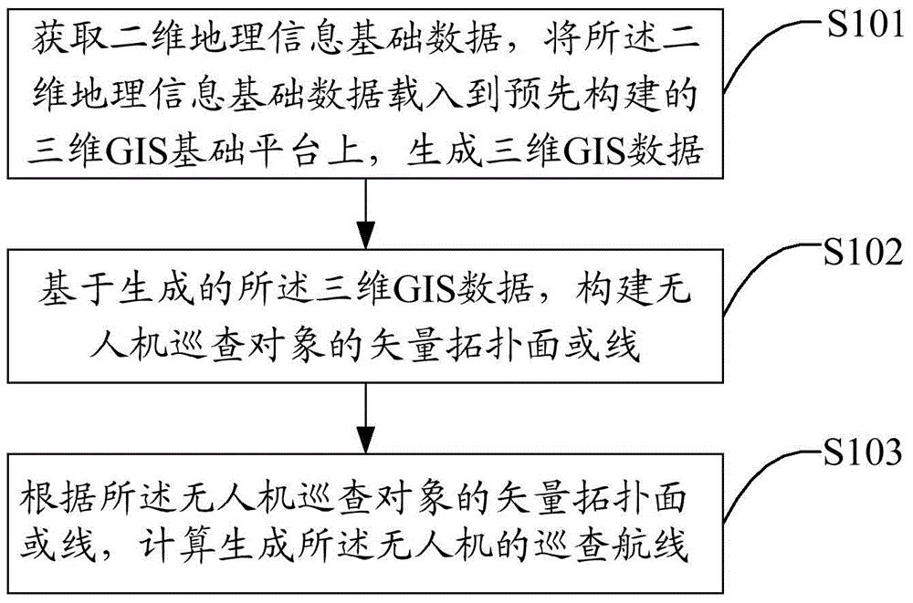
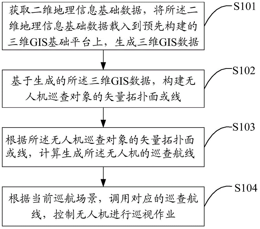
[0041] Specifically, such as figure 1 As shown, the first embodiment of the present invention proposes a method for cruising a drone, including:

[0042] Step S101, obtaining two-dimensional geographic information basic data, loading the two-dimensional geographic information basic data into a pre-built three-dimensional GIS basic platform, and generating three-dimensional GIS data;

[0043] The solution of this embodiment is mainly applied to unmanned aerial vehicles, which can be various unmanned aircrafts, unmanned ships, automobiles, etc., that is, unmanned sea, land and air can be used. For example, it is applied to the automatic inspection of road areas on the map by drones, the automatic inspection of long and narrow waters or rivers on the map, and the automatic inspection of high-voltage lines, power lines, and gas pipelines on the map by drones; Unmanned ships perform automatic cruises on narrow waters or rivers on the map; unmanned cars perform automatic driving di...


PUM


Abstract

The invention discloses an unmanned plane cruise method and an apparatus thereof. The method comprises the following steps: acquiring two-dimensional geographic information base data, and loading the two-dimensional geographic information base data into a pre-built three-dimensional GIS base platform to generate three-dimensional GIS data; constructing the vector topology surface or line of an unmanned plane patrol object based on the generated three-dimensional GIS data; and calculating according to the vector topology surface or line of the unmanned plane inspection object to generate an unmanned plane inspection course. The method and the apparatus realize automatic drafting of the unmanned plane course, improve the course drafting flexibility and the unmanned plane flight scheduling flexibility, solve the problem of difficult real-time automatic tour inspection of the unmanned plane control area of roads and rivers, and also solve the problem of automatic working of frequent tour inspection tasks needed by high voltage lines, pipelines and other dangerous members.

Description

technical field [0001] The present invention relates to the field of unmanned aerial vehicles and related technologies, in particular to a method and device for cruising an unmanned aerial vehicle. Background technique [0002] UAVs are usually used in many occasions, such as outdoor stage shooting, patrolling road areas, narrow waters or rivers, high-voltage lines, power lines, gas pipelines, etc. on the map. [0003] At present, the automatic flight of UAVs is based on the routes drawn manually in advance to perform flight tasks, and manual drawing of routes will delay a certain amount of time when actually performing emergency flight tasks. In addition, there is a large accuracy error in the manual judgment of the map. It is troublesome to execute the mission again after the first flight route is saved and the mission is changed. If you want to complete a mission that is quite different from the previous flight, you must redraw and Change the route, so the degree of auto...

Claims


Application Information

Patent Timeline
Patent Type & Authority Applications(China)
IPC IPC(8): G01C21/00G01C21/20
CPCG01C21/00G01C21/20
Inventor 张显志
Owner SICHUAN AEE AVIATION TECH CO LTD
Why Eureka
Try Eureka