LBL/MINS integrated navigation system and navigation information fusion method thereof

A combined navigation system and navigation system technology, applied in the field of underwater navigation and positioning, can solve the problem of large positioning error of MINS system, and achieve the effect of overcoming large positioning error, high-precision navigation without blind spots

Active Publication Date: 2015-11-18
江苏中海达海洋信息技术有限公司
View PDF5 Cites 19 Cited by
  • Summary
  • Abstract
  • Description
  • Claims
  • Application Information

AI Technical Summary

Problems solved by technology

[0003] The present invention proposes an LBL/MINS combined navigation system and its navigation information fusion method, which solves the positioning error of the MINS system when the LBL system cannot work for a long time in a

Method used


Image

  • LBL/MINS integrated navigation system and navigation information fusion method thereof
  • LBL/MINS integrated navigation system and navigation information fusion method thereof
  • LBL/MINS integrated navigation system and navigation information fusion method thereof

Examples


Embodiment Construction

[0024] The present invention and its effects will be further described below in conjunction with the accompanying drawings and embodiments.

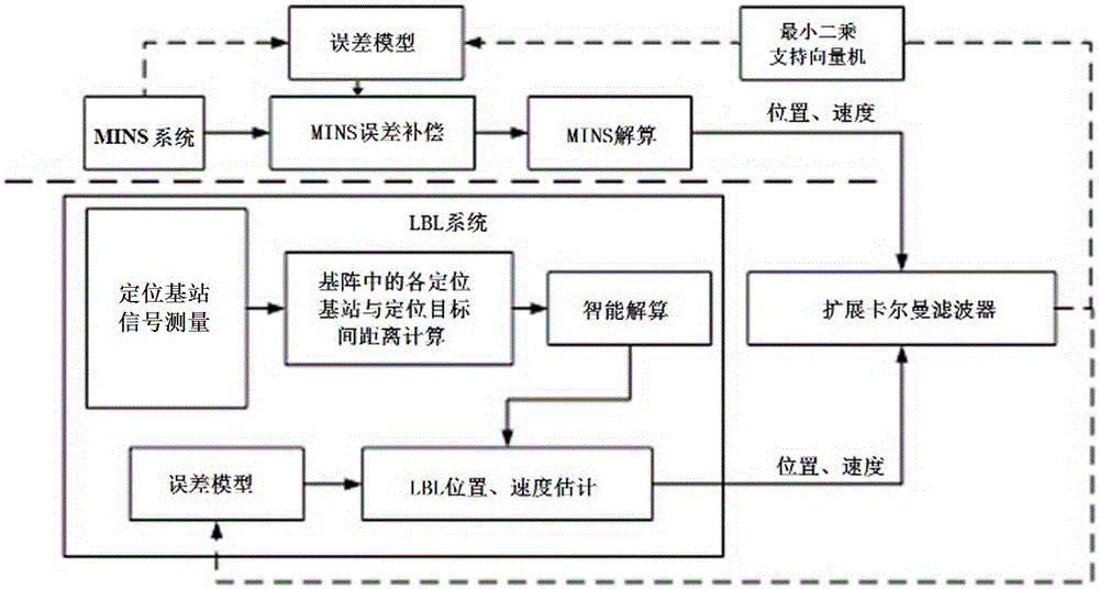
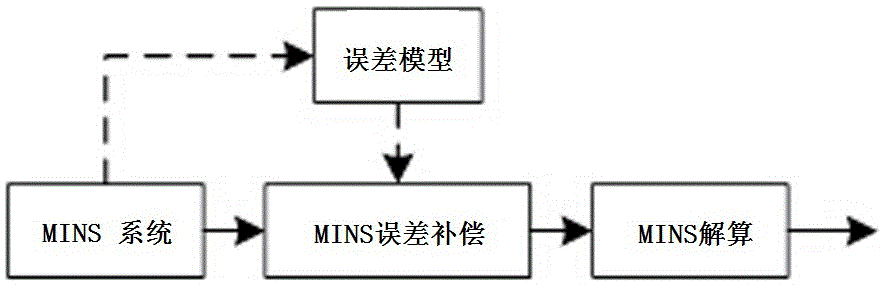
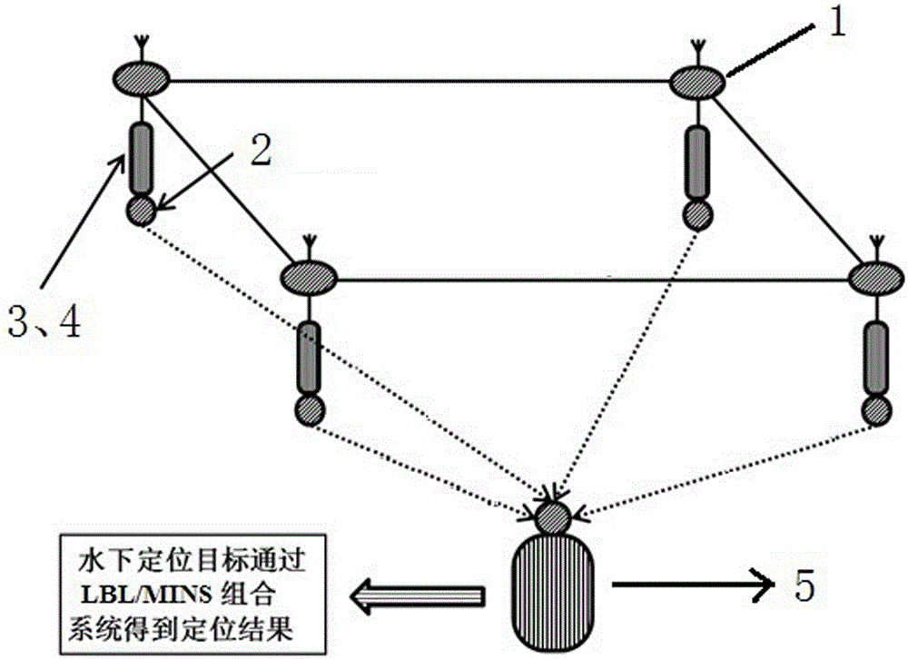
[0025] Such as figure 1 As shown, a LBL / MINS (LongBaseLine / MEMSInertialNavigationSystem) integrated navigation system belongs to the field of complex underwater environment integrated positioning technology. The navigation information of each system is fused to achieve high-precision real-time navigation in complex underwater environments. Including the long-baseline underwater acoustic positioning system LBL and the micro-inertial navigation system MINS, that is, the LBL system and the MINS system; the positioning information of the system is fused through the extended Kalman filter (EKF) between the two systems, and the optimal navigation is output The positioning result, the "optimal navigation and positioning result" mentioned here, is a term of the optimal estimation theory, which refers to the "optimum" under a certain estimation ...


PUM


Abstract

The invention discloses an LBL/MINS integrated navigation system and a navigation information fusion method thereof. The integrated navigation system comprises a long-base-line underwater acoustic positioning system (LBL) and a micro-inertial navigation system (MINS). Data fusion is performed on positioning information of the two systems through an extended Kalman filter, and an optimal navigation and positioning result is output; meanwhile, the extended Kalman filter feeds output positioning error information back to positioning error models of the two systems so that the positioning error models of the two systems can be corrected according to the positioning error information, and positioning information with the accuracy higher than that of positioning information obtained by any single navigation method can be obtained; based on the float type LBL, a least-square support vector machine is adopted for correcting the positioning error model of the MINS, and in an area without underwater acoustic signal blockage, error compensation is performed on navigation information of the MINS through the corrected positioning error model of the MINS. The defect that the positioning accuracy of a traditional MINS fluctuates along with time is overcome, and the navigation and positioning accuracy of the integrated navigation system is guaranteed.

Description

technical field [0001] The invention belongs to the technical field of underwater navigation and positioning, and relates to a long-distance and high-precision target positioning and tracking technology used in underwater caves, mountains and other complex underwater environments blocked by underwater acoustic wave signals, specifically referring to a combination of LBL / MINS A navigation system and its navigation information fusion method. Background technique [0002] In recent years, the development of the marine field and military needs have promoted the development of underwater high-precision positioning technology, and this demand will gradually become more urgent in the future. Among the existing underwater positioning methods, long-baseline underwater acoustic positioning technology and inertial navigation technology are the two most commonly used methods. Among them, underwater acoustic positioning technology is widely used in civilian fields such as industry, whil...

Claims


Application Information

Patent Timeline
IPC IPC(8): G01C21/16
CPCG01C21/165
Inventor 王熙赢罗宇施剑
Owner 江苏中海达海洋信息技术有限公司
Why Eureka
Try Eureka