Assisted planning and site selection method for network optimization based on space syntax

A space syntax and network optimization technology, applied in special data processing applications, instruments, electrical digital data processing, etc., can solve the problems that space syntax stays in the academic research stage and has not been widely used in engineering practice, so as to achieve optimal planning adaptability, Improve the scientific effect

Active Publication Date: 2015-12-16
SOUTH CHINA UNIV OF TECH
View PDF5 Cites 18 Cited by
  • Summary
  • Abstract
  • Description
  • Claims
  • Application Information

AI Technical Summary

Problems solved by technology

But at this stage, many space syntaxes are only in the academic re

Method used


Image

  • Assisted planning and site selection method for network optimization based on space syntax
  • Assisted planning and site selection method for network optimization based on space syntax
  • Assisted planning and site selection method for network optimization based on space syntax

Examples


Embodiment 1

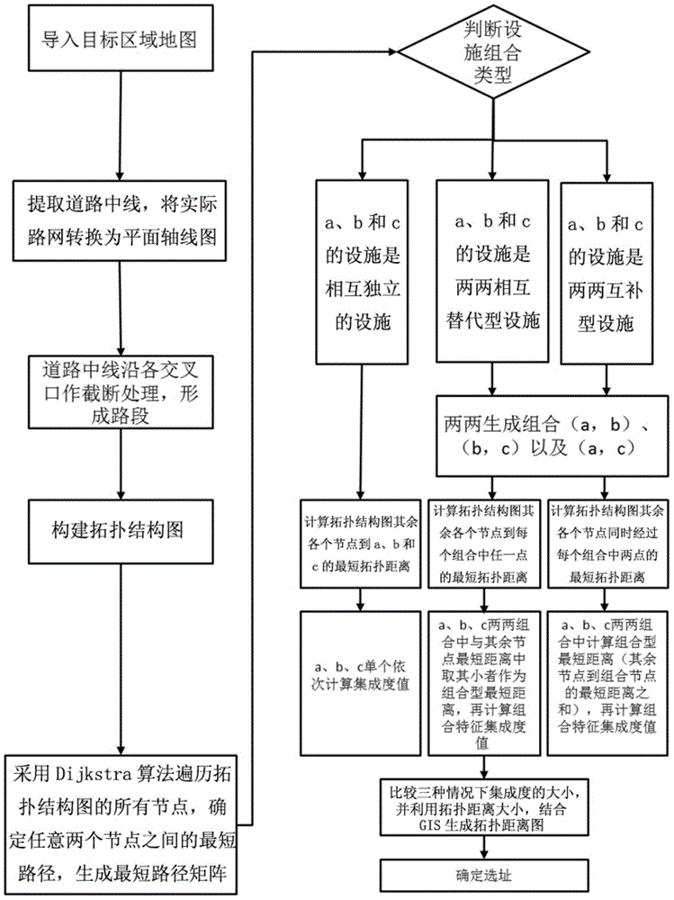
[0060] Such as figure 1 As shown, the auxiliary planning and site selection method of this embodiment includes the following steps:

[0061] 1) Build a topology diagram

[0062] Simplify the centerline of the extracted road from the urban road network, and break it along the intersection, establish the topological relationship of each road section, and use the topological relationship for spatial analysis and calculation.

[0063] 1.1) Establish road network structure

[0064] Import the map of the target area (usually a street map) into AutoCAD, extract the center line of the road according to the principle of space syntax convex polygon, redraw the center of the same road, convert the actual road network into a plane axis map, and establish the road network structure ;

[0065] 1.2) Form a road segment

[0066] According to the intersection of roads, the center line of each road in the planar axis diagram is subdivided again, that is, the section is processed along the i...

Embodiment 2

[0124] This embodiment is an application example, and the algorithm optimization test is performed on a local road network of a certain city. The steps mainly include:

[0125] 1) Carry out grid division on the actual road network through AutoCAD and convert it into a planar axis diagram of road segments, such as Figure 5 shown.

[0126] 2) Convert the planar axis diagram of the subdivision into a topological structure diagram with space syntax properties.

[0127] 3) Establish an unweighted adjacency matrix according to the association between nodes. Adjacent nodes are set to 1, and non-adjacent nodes and diagonal values ​​are set to 0. When initializing the adjacency matrix W in the MATLAB code of the shortest path, it is necessary to pass The find function finds the element with 0 in the adjacency matrix, that is, the non-adjacent node or the node itself, and then replaces it with inf, that is, the distance between non-adjacent nodes is considered to be infinite. The adja...


PUM


Abstract

The present invention discloses an assisted planning and site selection method for network optimization based on space syntax. The method comprises the steps: introducing a target area map in AutoCAD, extracting a road center line, and converting an actual road network into a plane axis graph; intercepting, according to the road intersecting condition, along an intersection of each road center line of the plane axis graph to form a road system with end to end; converting the road system of the plane axis graph into a topological structure diagram with a space syntax attribute; using a Dijkstra algorithm to traverse all nodes of the topological structure diagram, and determining a shortest path between any two nodes to generate a shortest path matrix; and judging a facility combination type of any three nodes in the topological structure diagram, and determining reasonable site selection of the facility by the shortest path according to a behavior requirement. By introducing the space syntax as the basis of the algorithm, the method disclosed by the invention optimizes the planning adaptability of the space syntax, and the scientificity of planning site selection is improved by taking the integration of the optimized space syntax as a quantitative criterion for site selection by comparison.

Description

technical field [0001] The invention relates to an auxiliary planning and site selection method, in particular to an auxiliary planning and site selection method based on space syntax network optimization, which belongs to the technical application in the field of urban and rural planning and design. Background technique [0002] The city is the most important carrier of human economic and social activities. The overall structure of the city is affected by urban facilities, and urban facilities are also closely related to the daily life of citizens. With the rapid development of cities, urban construction requires planning and site selection for various types of facilities. Traditional facility site selection methods are mainly based on the service radius of facilities and the subjective experience of planning and design personnel. The limitation lies in the high uncontrollability of operations. Low efficiency, many uncertain factors, etc. [0003] Quantitative research on ...

Claims


Application Information

Patent Timeline
IPC IPC(8): G06F17/50
Inventor 赵渺希宋立新江波黄俊浩张平成
Owner SOUTH CHINA UNIV OF TECH
Why Eureka
Try Eureka