
Centimeter-level positioning method of pseudo satellite

A positioning method and pseudolite technology, applied in the field of pseudolite centimeter-level positioning, can solve the problem that satellite navigation signals cannot achieve high-precision positioning

Inactive Publication Date: 2015-12-23
NO 54 INST OF CHINA ELECTRONICS SCI & TECH GRP
View PDF7 Cites 13 Cited by
  • Summary
  • Abstract
  • Description
  • Claims
  • Application Information

AI Technical Summary

Problems solved by technology

[0005] The purpose of the present invention is to design a pseudolite centimeter-level positioning method for the application field where satellite navigation signals cannot achieve high-precision positioning due to the blocking of buildings

Method used


Image

  • Centimeter-level positioning method of pseudo satellite
  • Centimeter-level positioning method of pseudo satellite
  • Centimeter-level positioning method of pseudo satellite

Examples


Embodiment Construction

[0029] The present invention will be further described below with reference to specific embodiments and accompanying drawings.

[0030] A pseudolite centimeter-level positioning method, comprising the following steps:

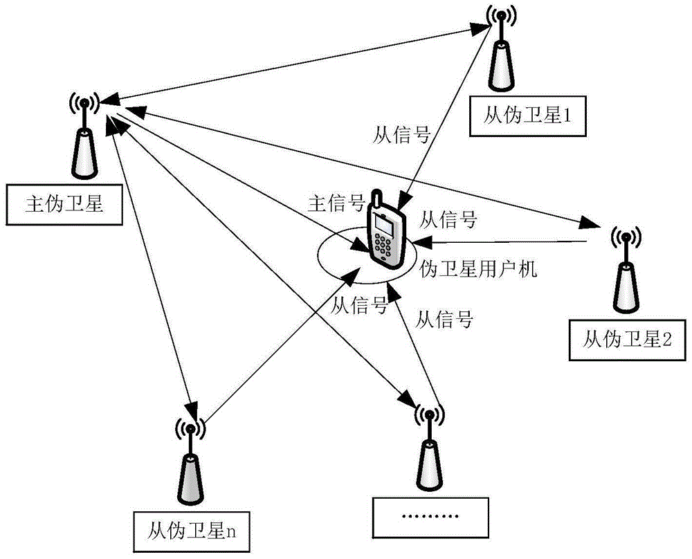
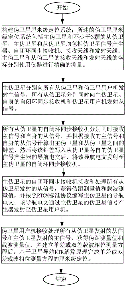
[0031] ①Construct a pseudolite centimeter-level positioning system; the pseudolite centimeter-level positioning system includes a master pseudolite and no less than 3 slave pseudolites, and both the master pseudolite and slave pseudolites include a pseudolite signal generator, a self-closed loop Synchronize the receiver, the receiving antenna and the transmitting antenna; the coordinates of the receiving and transmitting antennas of the master and slave pseudolites, respectively, are accurately measured using the instrument.

[0032] ②The master pseudolite transmits master signals to all slave pseudolites and pseudolite user computers respectively, and all slave pseudolites simultaneously transmit slave signals to the master pseudolite, its own self-closed loop...


PUM


Abstract

The invention, which relates to the satellite navigation and radio positioning field, discloses a centimeter-level positioning method of a pseudo satellite. The method comprises: firstly, a centimeter-level positioning system of pseudo satellites is constructed; secondly, a master pseudo satellite transmits a master signal to all slave pseudo satellites and all slave pseudo satellites transmit slave signals to the master pseudo satellite; thirdly, self-closed-loop synchronous receivers of the slave pseudo satellites calculate clock errors between the master pseudo satellite and the slave pseudo satellites and write navigation messages and the navigation messages are transmitted to the master pseudo satellite; fourthly, the master pseudo satellite receive all slave signals to obtain a pseudo range measurement value and a carrier wave measurement value, and a navigation message is compiled according to an RTC standard protocol; and fifthly, a pseudo satellite user machine receives all slave signals and master signals, after obtaining of the pseudo range measurement value and the carrier wave measurement value, a single-error or dual-error measurement equation is established, and integer-cycle fuzziness resolving and centimeter-level positioning are completed based on a satellite navigation RTK resolving principle. With the method, high-precision positioning of a pseudo satellite can be realized; and the method has advantages of low cost and high simpleness and practicability.

Description

technical field [0001] The invention relates to the field of satellite navigation and radio positioning, in particular to a pseudolite centimeter-level positioning method. Background technique [0002] At present, the need for positioning is becoming more and more urgent, and people hope to know their location in large shopping malls, public places, and long high-speed tunnels. [0003] Satellite navigation systems represented by Beidou and GPS are more and more widely used, and have become indispensable functions such as smart phones and car navigators. However, the satellite navigation signal cannot penetrate the wall of the building due to the blocking effect of the building, so that the satellite navigation receiver loses the positioning function. [0004] Based on the above reasons, a pseudolite device compatible with BeiDou and GPS navigation signals is needed, which can realize centimeter-level positioning methods under the condition that the software and hardware mo...

Claims


Application Information

Patent Timeline
IPC IPC(8): G01S19/42G01S19/33
CPCG01S19/425G01S19/33
Inventor 甘兴利蔚保国
Owner NO 54 INST OF CHINA ELECTRONICS SCI & TECH GRP
Learn More