Navigation data processing method and system based on cloud computing

A navigation data and cloud computing technology, applied in the field of satellite navigation, can solve problems such as poor orbit determination accuracy, difficult overseas deployment of the Beidou system, enhanced information broadcast transmission delay, etc., to reduce dependence, ensure joint orbit determination and time synchronization , Improve the effect of system service performance

Inactive Publication Date: 2018-12-14
BEIJING FUTURE NAVIGATION TECH CO LTD
View PDF4 Cites 22 Cited by
  • Summary
  • Abstract
  • Description
  • Claims
  • Application Information

AI Technical Summary

Problems solved by technology

[0004] Existing GNSS augmentation systems rely on GEO satellites, but GEO satellites remain relatively stationary relative to ground reference stations, resulting in a strong correlation between observations and orbits, ambiguities, and clock errors, resulting in poor orbit determination accuracy
Moreover, due to the high altitude of the GEO satellite orbit, the transmission delay of the enhanced information broadcast is long, and the path loss
In addition, due to the limited number of GEO satellites and the difficulty of deploying overseas stations for the Beidou system, the monitoring stations are mainly distributed in mainland China and cannot achieve true global coverage. The regional distribution of monitoring stations affects the accuracy of navigation satellite broadcast ephemeris and the corresponding positioning, navigation and timing services

Method used


Image

  • Navigation data processing method and system based on cloud computing
  • Navigation data processing method and system based on cloud computing
  • Navigation data processing method and system based on cloud computing

Examples


Embodiment Construction

[0059] Exemplary embodiments of the present disclosure will be described in more detail below with reference to the accompanying drawings. Although exemplary embodiments of the present disclosure are shown in the drawings, it should be understood that the present disclosure may be embodied in various forms and should not be limited by the embodiments set forth herein. Rather, these embodiments are provided for more thorough understanding of the present disclosure and to fully convey the scope of the present disclosure to those skilled in the art.

[0060] Those skilled in the art can understand that, unless otherwise defined, all terms (including technical terms and scientific terms) used herein have the same meaning as commonly understood by those of ordinary skill in the art to which this invention belongs. It should also be understood that terms, such as those defined in commonly used dictionaries, should be understood to have meanings consistent with the meanings in the co...


PUM


Abstract

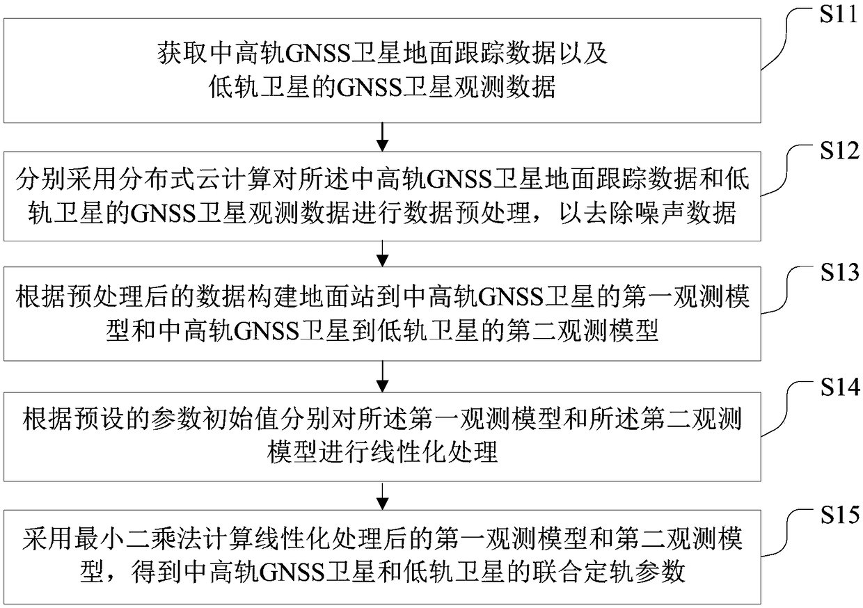
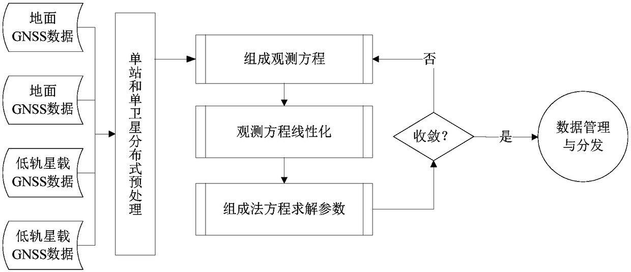
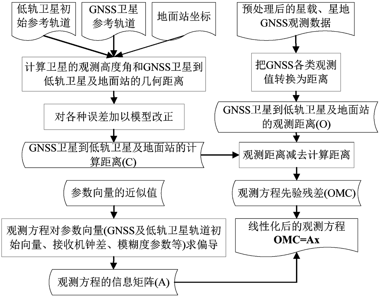
The invention provides a navigation data processing method and system based on cloud computing. The method comprises the steps that ground tracking data of a medium and high earth orbit GNSS satelliteand GNSS satellite observation data of a low earth orbit satellite are acquired; distributed cloud computing is adopted to preprocess the ground tracking data of the medium and high earth orbit GNSSsatellite and the GNSS satellite observation data of the low earth orbit satellite; a first observation model from a ground station to the medium and high earth orbit GNSS satellite and a second observation model from the medium and high earth orbit GNSS satellite to the low earth orbit satellite are constructed according to the preprocessed data; linearization processing is performed on the firstobservation model and the second observation model according to preset parameter initial values; and a least square method is adopted to calculate the first observation model and the second observation model after linearization, and joint orbit determination parameters of the medium and high earth orbit GNSS satellite and the low earth orbit satellite are obtained. Through the navigation data processing method and system, an orbit of the low earth orbit satellite can be determined with high precision, joint orbit determination and time synchronization of the navigation satellite and the low earth orbit satellite are realized, therefore, real-time high-precision service is provided for a user, and system service performance is improved.

Description

technical field [0001] The invention relates to the technical field of satellite navigation, in particular to a navigation data processing method and system based on cloud computing. Background technique [0002] The theory of precise satellite orbit determination began in the 1950s. With the development of satellite tracking technology, the improvement of observation accuracy, and the continuous refinement of data processing error models and dynamic models, the accuracy of navigation satellite orbit determination has been significantly improved. In particular, the orbit determination accuracy of GPS and GLONASS satellites has been improved from the initial hundreds of meters to the current centimeter level. The satellite tracking data of traditional navigation satellite precise orbit determination methods all come from ground stations, and the geographical distribution of tracking stations will directly affect the precision of navigation satellite precise orbit determinatio...

Claims


Application Information

Patent Timeline
Patent Type & Authority Applications(China)
IPC IPC(8): G01S19/39G01S19/42
CPCG01S19/39G01S19/425
Inventor 穆旭成
Owner BEIJING FUTURE NAVIGATION TECH CO LTD
Why Eureka
Try Eureka