Method for model automatic conversion from OSM (OpenStreetMap) data to professional GIS vector data and dynamic integration of OSM incremental data

A technology of vector data and incremental data, applied in digital data processing, structured data retrieval, geographic information database, etc., can solve problems such as high labor costs

Active Publication Date: 2015-12-23
CENT SOUTH UNIV
View PDF3 Cites 10 Cited by
  • Summary
  • Abstract
  • Description
  • Claims
  • Application Information

AI Technical Summary

Problems solved by technology

However, because the quality control process still requires a lot of manual intervention, it is a high labor cost work, so we cannot repeat the model conversion, false and low-quality data filtering, repeated target optimization, scattered target integration, and topology on new OSM data every day. Consistency check and correction, and integration with other data sources to supplement incomplete data and other operations to maintain the current status of overseas data

Method used


Image

  • Method for model automatic conversion from OSM (OpenStreetMap) data to professional GIS vector data and dynamic integration of OSM incremental data
  • Method for model automatic conversion from OSM (OpenStreetMap) data to professional GIS vector data and dynamic integration of OSM incremental data
  • Method for model automatic conversion from OSM (OpenStreetMap) data to professional GIS vector data and dynamic integration of OSM incremental data

Examples


Embodiment 1

[0061] Example 1: Model conversion from OSM data to professional GIS data
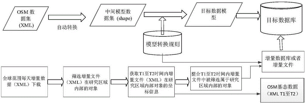
[0062] The overall idea of ​​model conversion from OSM data to professional GIS data is attached figure 2 shown. The model conversion from OSM data to professional GIS vector data includes two core tasks, that is, geometry type conversion and core attribute conversion. Geometric type conversion is about converting OSM vector data expressed by node, way, and relation into point, line, and area objects of professional GIS vector data; core attribute conversion is to use a rule-based method to convert points, lines, and areas from OSMXML format Assign the feature code of the target model, and determine the corresponding target layer according to the feature code.

[0063] Geometry type conversion is performed using the following four rules:

[0064] Let OSMGeoPrim represent the original OSM geometry type of the object, namely node, way, relation, and OSMtag.k and OSMtag.V represent the value of a pair...

Embodiment

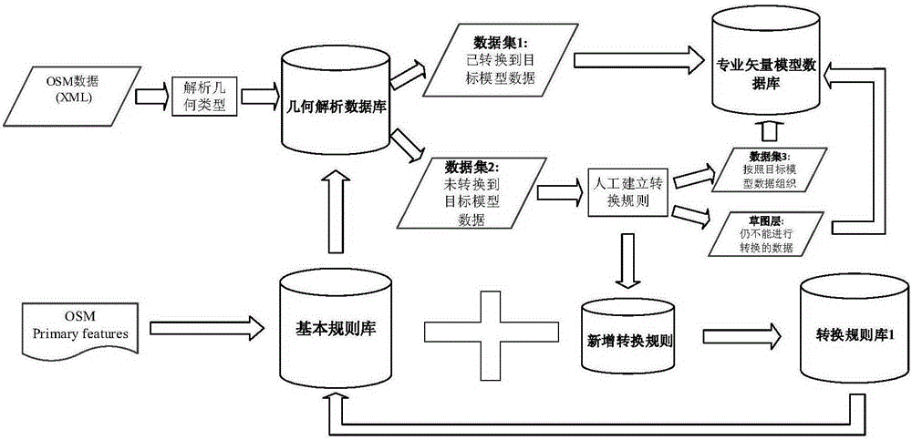
[0081] Using VisualStudioC# language, object-oriented method, based on the OGC (OpenGIS Consortium) standard, the data layer, business logic layer and map display layer are logically and physically separated, and a dynamic integration system for overseas peripheral geographic information has been developed (the computer has been obtained) Software copyright, 2014SR217380), realizes OSM data storage, rule addition and deletion, data model conversion and other functions, and uses open source database PostgreSQL to manage data.

[0082] my country's 1:50,000 surrounding geographic information model is used as the conversion target model, which includes seven categories, including water system, residential areas and facilities, transportation, pipelines, boundaries and political areas, landforms and soil quality, and vegetation. Different categories are subdivided into different feature layers according to the geometric types of features, and each object has a different feature cod...


PUM


Abstract

The present invention discloses a method for model automatic conversion from OSM data to professional GIS vector data and dynamic integration of OSM incremental data. The method comprises: downloading XML OSM vector data expressed by node, way and relation, and converting the OSM vector data into a user vector data model by using a rule repository to obtain basic state data sometime and somewhere; by using OSM daily global change data, screening incremental data of a research zone by calculating a topological relationship between a change object considering a version evolution process and an object in a Diff file; determining a change type of the object after integration by applying an incremental data integration method which considers an evolution process of a change type between adjacent versions to multi-version incremental data; and finally updating original OSM basic state data by using the obtained incremental data. The method can obtain overseas geospatial vector data of our country efficiently and cost-effectively and maintain the up-to-date state of the data.

Description

technical field [0001] The invention belongs to the technical field of crowd source geographic information (volunteer geographic information, VGI), and in particular relates to a method for automatic model conversion from OpenStreetMap (OSM) to professional GIS vector data and a dynamic integration method for OSM incremental data. Background technique [0002] In recent years, with the deepening of my country's reform and opening up and the development of world globalization, the pace of "going out" of my country's enterprises and citizens has accelerated. According to statistics, there are more than 20,000 overseas Chinese-funded enterprises in my country, covering nearly 200 countries and regions; in 2014, the number of outbound Chinese citizens reached 117 million. However, overseas public security incidents that endanger the life and property safety of Chinese enterprises and citizens occur from time to time. In 2014, the Ministry of Foreign Affairs handled a total of 59...

Claims


Application Information

Patent Timeline
Patent Type & Authority Applications(China)
IPC IPC(8): G06F17/30
CPCG06F16/29
Inventor 周晓光曾璐江瑜陆琪
Owner CENT SOUTH UNIV
Why Eureka
Try Eureka