Geographic grid mapping method of mobile network data

A mobile network data and grid technology, applied in network planning, service based on location information, electrical components, etc., can solve the problem that the coverage of the cell may not be continuous

Active Publication Date: 2015-12-23
BEIJING TUOMING COMM TECH
View PDF5 Cites 16 Cited by
  • Summary
  • Abstract
  • Description
  • Claims
  • Application Information

AI Technical Summary

Problems solved by technology

The actual network coverage will be quite different from this. Due to the factors of data accuracy, parameter control, capacity and propagation environment, the coverage of the cell may not be continuous, and the boundary between cells will not be a very regular continuous curve, so this One method has many disadvantages

Method used


Image

  • Geographic grid mapping method of mobile network data
  • Geographic grid mapping method of mobile network data
  • Geographic grid mapping method of mobile network data

Examples


Embodiment Construction

[0036] The present invention will be described in detail below in conjunction with the accompanying drawings and embodiments.

[0037] The present invention provides a method for geographic grid mapping of mobile network data, including the following key steps:

[0038] (1) First, mathematical modeling is carried out based on the existing massive DT drive test data to form the corresponding relationship between the actual geographical area grid (marketing area) and the base station cell identifier LAC / CI, and the system system is used to obtain the following comparison table Grid(n ): grid number, plot, number of sampling points, total number of sampling points, distribution ratio of sampling points, coverage weight;

[0039] The specific steps of mathematical modeling based on the existing massive DT drive test data are as follows:

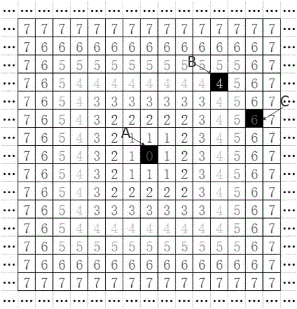
[0040] (1-1) Rasterize the geographical area where the mobile network is located to establish a reference coordinate system. Firstly, a rectan...


PUM


Abstract

The invention discloses a geographic grid mapping method of mobile network data, and belongs to the field of mobile communication network optimization and analysis. The steps are as follows: firstly, carrying out mathematical modeling based on the existing massive DT drive test data, forming a corresponding relationship between an actual geographic area grid and a base station cell identifier, and analyzing the system format to obtain the following comparison table: grid numbers, cells, the number of sampling points, a total number of the sampling points, a distribution ratio of the sampling points and a coverage weight; normalizing the obtained comparison table, and carrying out linear interpolation calculations on geographic grids having no data with reference to geographic grids having data to obtain a new comparison table having the same structure; carrying out statistical calculation from a whole network angle based on the new comparison table, and updating the coverage weights of the cells in the geographic grids to facilitate the geographic grid mapping calculation of the mobile network data in the next step. The mobile network data are concluded in several categories, and the mobile network data are mapped into the corresponding geographic grids according to the comparison table established in the last step.

Description

technical field [0001] The invention relates to the field of mobile communication network optimization analysis, in particular to a method for geographic grid mapping of mobile network data. Background technique [0002] Due to historical legacy and technological evolution, current operators are often faced with complex scenarios where 2G, 3G, 4G, and WLAN networks coexist. Due to differences in cost and technical characteristics, operators need to fully consider the conditions of each network when analyzing network operations, which requires the use of multi-network collaborative analysis and optimization methods. The conventional analysis object and optimization unit is often a certain base station (cluster) or a certain cell (cluster), although sometimes the analysis object and optimization unit will be extended to a certain grid or area, but in fact the main object of data subdivision is still is the network element dimension. However, the reality is that the main obje...

Claims


Application Information

Patent Timeline
Patent Type & Authority Applications(China)
IPC IPC(8): H04W4/02H04W16/18H04W24/02H04W24/08
CPCH04W4/02H04W16/18H04W24/02H04W24/08
Inventor 王广善常青
Owner BEIJING TUOMING COMM TECH
Why Eureka
Try Eureka