
Method for extracting earthquake-induced landslide volume by using TanDEM-X bistatic InSAR

A seismic landslide and volume technology, applied in the field of satellite remote sensing applications, can solve problems such as error, low efficiency of seismic landslide volume, and difficulty in obtaining seismic landslide volume, achieving high-precision, high-resolution, and low-cost effects

Active Publication Date: 2015-12-30
INST OF GEODESY & GEOPHYSICS CHINESE ACADEMY OF SCI
View PDF6 Cites 11 Cited by
  • Summary
  • Abstract
  • Description
  • Claims
  • Application Information

AI Technical Summary

Problems solved by technology

GPS field measurement and 3D laser LiDAR have the advantages of high observation accuracy, especially 3D laser LiDAR can obtain high-resolution point cloud terrain data of the entire landslide surface, and can accurately obtain the volume of earthquake landslides, but the number of earthquake landslides is usually tens of thousands, or even several 100,000, the efficiency of this method to extract regional earthquake landslide volume is low; optical remote sensing can obtain distribution parameters such as the center point, boundary, and area of ​​earthquake landslides in a large range, and extract the volume of earthquake landslides through empirical formulas or models, but the empirical formula Or the model brings inevitable errors to the final earthquake landslide volume, and it is difficult to obtain the earthquake landslide volume quantitatively and accurately
Moreover, after the earthquake, there will be continuous rainfall for a long period of time, and it is difficult to extract the volume of seismic landslides by optical remote sensing.

Method used


Image

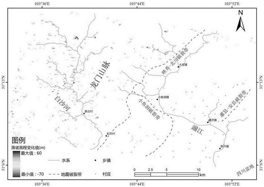
  • Method for extracting earthquake-induced landslide volume by using TanDEM-X bistatic InSAR
  • Method for extracting earthquake-induced landslide volume by using TanDEM-X bistatic InSAR
  • Method for extracting earthquake-induced landslide volume by using TanDEM-X bistatic InSAR

Examples


Embodiment Construction

[0037] The present invention will be described in detail below in conjunction with the accompanying drawings and embodiments.

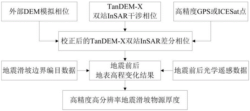
[0038] refer to figure 1 As shown, the method for extracting seismic landslide volume using TanDEM-X dual-station InSAR described in the present invention obtains the corrected TanDEM-X dual-station InSAR interferometric phase, external DEM simulation phase, high-precision GPS or ICESat correction point X dual-station InSAR differential phase, and then obtain the results of surface elevation changes before and after the earthquake, and then combine the earthquake landslide boundary catalog data, optical remote sensing data before and after the earthquake to obtain the volume of the earthquake landslide, and combine the parameters of the landslide area to obtain high-precision and high-resolution earthquake landslide objects source thickness.

[0039]The dual-station InSAR interferometric phase is obtained from the SAR data of two satellites TanDEM-X ...


PUM


Abstract

The invention discloses a method for extracting earthquake-induced landslide volume by using a TanDEM-X bistatic InSAR. The method includes the following steps of: 1) bistatic InSAR interferometric phase calculation; 2) bistatic InSAR differential phase estimation; 3) pre-earthquake and post-earthquake ground surface elevation change estimation; and 4) earthquake-induced landslide volume calculation. The differential phase of the corrected TanDEM-X bistatic InSAR can be acquired through TanDEM-X bistatic InSAR interferometric phase, external DEM simulation phase and high-precision GPS or ICESat correction points; pre-earthquake and post-earthquake ground surface elevation change results can be obtained; and earthquake-induced landslide volume can be calculated through earthquake-induced landslide boundary catalogue data, pre-earthquake and post-earthquake optical remote sensing data. The method for extracting the earthquake-induced landslide volume has advantage of high resolution, high accuracy, capability of extracting face-shaped and large-area earthquake-induced landslide volume, and low cost. With the method adopted, ground measuring equipment is not required to be laid.

Description

technical field [0001] The invention belongs to the field of satellite remote sensing applications, and specifically relates to a method for extracting the volume of earthquake landslides by using TanDEM-X dual-station InSAR, using TanDEM-X dual-station InSAR to obtain the surface elevation change before and after the earthquake, and then quantitatively estimate the volume of regional earthquake landslides, which can be used in Global regional expansion application. Background technique [0002] In recent years, earthquakes are likely to cause a large number of secondary geological disasters such as landslides and mud-rock flows, which pose a huge threat to people's living environment and the safety of life and property. They are also important diseases of railways, highways and other transportation facilities. It is an urgent task for the reconstruction and economic development of earthquake-stricken areas to extract the volume of regional earthquake landslides and assess t...

Claims


Application Information

Patent Timeline
Patent Type & Authority Applications(China)
IPC IPC(8): G01V3/38
Inventor 江利明孙亚飞
Owner INST OF GEODESY & GEOPHYSICS CHINESE ACADEMY OF SCI
Learn More