Method and system for displaying icon data at multiple GIS display terminals

A data display and display terminal technology, applied in the field of GIS display, can solve the problems of poor display effect and low display efficiency, and achieve the effect of improving effect and efficiency

Active Publication Date: 2016-01-27
GUANGDONG VTRON TECH CO LTD
View PDF7 Cites 5 Cited by
  • Summary
  • Abstract
  • Description
  • Claims
  • Application Information

AI Technical Summary

Problems solved by technology

[0004] Based on this, it is necessary to provide a multi-GIS display terminal icon data display method and system for the technical problems of low d

Method used


Image

  • Method and system for displaying icon data at multiple GIS display terminals
  • Method and system for displaying icon data at multiple GIS display terminals

Examples


Embodiment Construction

[0018] The specific implementation of the method and system for displaying icon data at the multi-GIS display terminal of the present invention will be described in detail below in conjunction with the accompanying drawings.

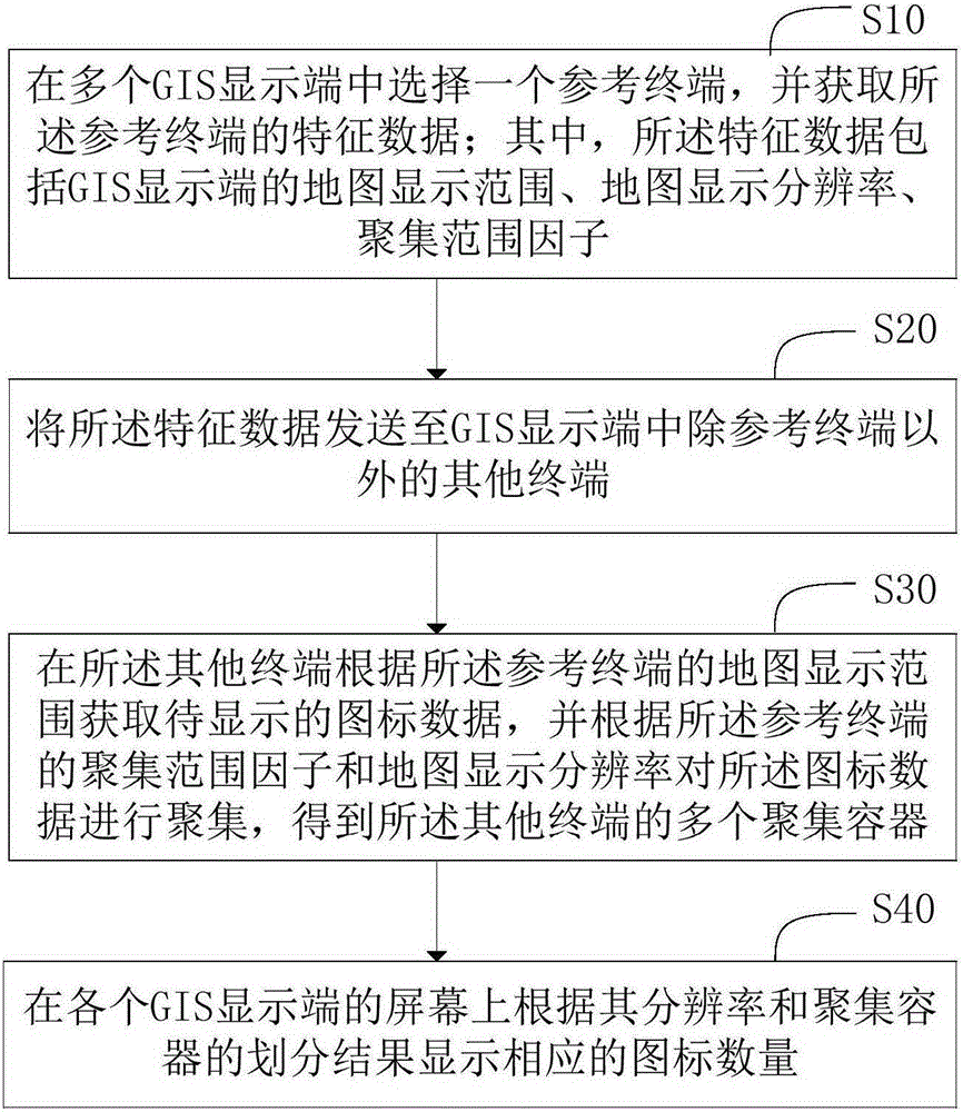
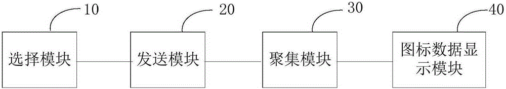
[0019] refer to figure 1 , figure 1 Shown is a flow chart of a multi-GIS display terminal icon data display method of an embodiment, including the following steps:

[0020] S10, select a reference terminal among a plurality of GIS display terminals, and obtain characteristic data of the reference terminal; wherein, the characteristic data includes the map display range, map display resolution, and aggregation range factor of the GIS display terminal;

[0021] In the above step S10, when a large number of identical icon data are displayed at the same time through multiple GIS display terminals, any one of these GIS display terminals can be selected as a reference terminal, and according to the display principle of the icon data on the above reference ter...


PUM


Abstract

The invention relates to a method and a system for displaying icon data at multiple GIS display terminals. The method for displaying icon data at multiple GIS display terminals comprises the steps of firstly, selecting one GIS display terminal out of the multiple GIS display terminals as a reference terminal, and acquiring the feature data of the reference terminal; secondly, sending the feature data to all the other terminals of the multiple GIS display terminals, except the reference terminal; thirdly, acquiring to-be-displayed icon data by all the other terminals according to the map display range of the reference terminal, and aggregating the icon data according to the aggregation range factor of the reference terminal and the map display resolution to obtain multiple aggregation containers for all the other terminals, wherein the icon data contain longitude and latitude values for describing the positions of icons; fourthly, displaying the number of corresponding icons on the screen of each GIS display terminal according to the resolution and the division result of the aggregation containers thereof. According to the invention, the efficiency of displaying a large number of identical icon data on different GIS display terminals is improved. Meanwhile, the display effect of the icon data on each GIS display terminal is also improved.

Description

technical field [0001] The invention relates to the technical field of GIS display, in particular to a method and system for displaying icon data of multiple GIS display terminals. Background technique [0002] In the field of computer display technology, it is often necessary to visually display a large amount of point data on multiple GIS display terminals at the same time. The existing technology usually draws the large data volume points in the record point data file or database one by one on different GIS display terminals, and uses an icon to represent a point on the display terminal, for example, there is a city video point map with a data volume of 1 million Layer, in order to see this video point layer data on different screens at the same time, technicians usually draw these 1 million icons on the screens with different resolutions of GIS display terminals to represent the 1 million video points. [0003] According to the above method to draw icon points with a la...

Claims


Application Information

Patent Timeline
IPC IPC(8): G06F3/14
Inventor 陈泓坤
Owner GUANGDONG VTRON TECH CO LTD
Why Eureka
Try Eureka