BIM-based unmanned aerial vehicle monitoring method and system

A monitoring system and unmanned aerial vehicle technology, applied in the field of unmanned aerial vehicles, can solve the problems of difficult monitoring, waste of time, and slow down the progress of the project, so as to save manpower, monitor accurately, and improve work efficiency.

Inactive Publication Date: 2016-02-17
SHANGHAI TONGZHU INFORMATION TECH
View PDF7 Cites 30 Cited by
  • Summary
  • Abstract
  • Description
  • Claims
  • Application Information

AI Technical Summary

Problems solved by technology

Its disadvantages are: it is difficult to conduct large-scale, global, and multi-angle monitoring of the building's exterior, overall, and building overlooking angles, and video monitors need to be pre-set. It is not suitable for monitoring building facades and construction sites that are constantly changing structures. Video surveillance The device occupies the construction space, the confirmation and notification of the position of the working condition stays at the drawing stage, and it is impossible to clearly display the working condition and compare the building components
[0009] (1) Real scene monitoring: Manual survey is not comprehensive and meticulous. When manual observation of a floor finds a problem with a certain floor, it is necessary to go to that floor to check in detail, which requires a lot of manpower. It is even more important to grasp the dynamic information of the project progress in time. difficulty
[0010] (2) Simulation and simulation: Traditional project documents use two-dimensional graphic design drawings, which cannot be compared with physical buildings very well, and it is also a waste of time to carry a large number of drawings around for reference. Different groups of people need to read different files, which wastes a lot of time and manpower
On the contrary, delays in the construction period will bring huge economic losses
Furthermore, the project is affected by many factors such as weather and climate, and traditional monitoring methods have seriously slowed down the progress of the project.

Method used


Image

  • BIM-based unmanned aerial vehicle monitoring method and system
  • BIM-based unmanned aerial vehicle monitoring method and system

Examples


Embodiment Construction

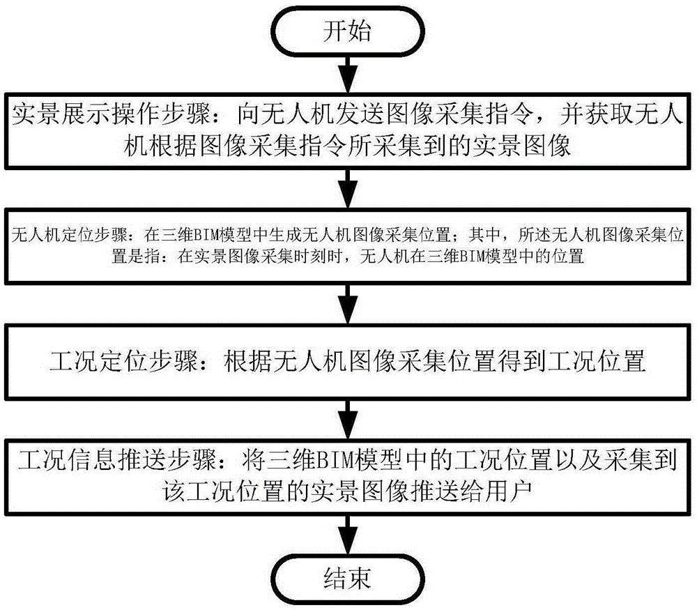
[0063] The present invention will be described in detail below in conjunction with specific embodiments. The following examples will help those skilled in the art to further understand the present invention, but do not limit the present invention in any form. It should be noted that those skilled in the art can make several changes and improvements without departing from the concept of the present invention. These all belong to the protection scope of the present invention.

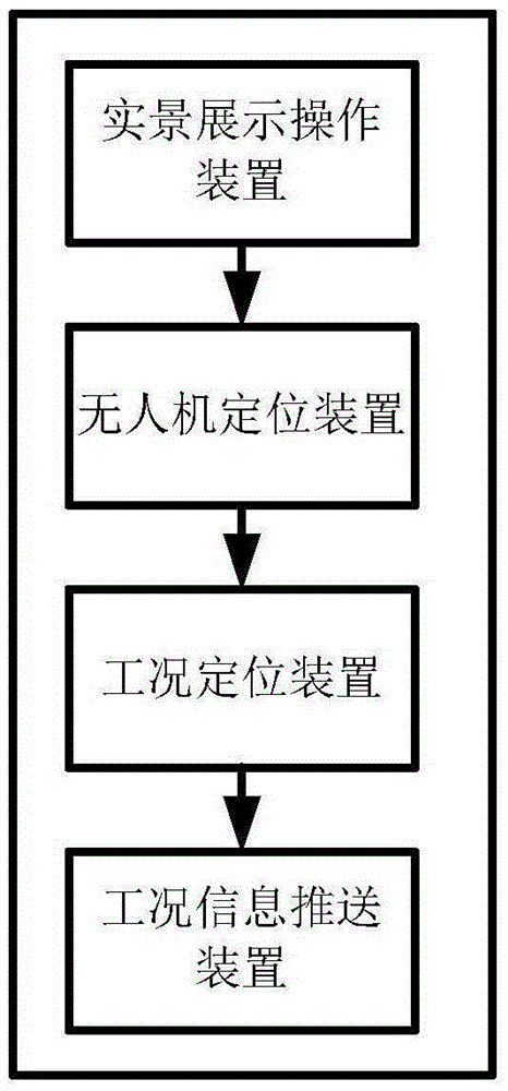
[0064] A kind of unmanned aerial vehicle monitoring system based on BIM provided according to the present invention, comprises following device:

[0065] Real-scene display operating device: used to send image acquisition instructions to the UAV, and obtain the real-scene images collected by the UAV according to the image acquisition instruction;

[0066] UAV positioning device: used to generate the UAV image acquisition position in the three-dimensional BIM model; wherein, the UAV image acquisition pos...


PUM


Abstract

The invention provides a BIM-based unmanned aerial vehicle monitoring method and system. The method comprises a real scene operation step, an unmanned aerial vehicle positioning step and a work condition positioning step. According to the real scene operation step, an unmanned aerial vehicle is operated, an image collection instruction is transmitted to the unmanned aerial vehicle, and real scene images collected by the unmanned aerial vehicle according to the image collection instruction are obtained. According to the unmanned aerial vehicle positioning step, an unmanned aerial vehicle image collection position is generated in a three-dimensional BIM model, wherein the unmanned aerial vehicle image collection position is the position of the unmanned aerial vehicle in the three-dimensional BIM model at a real scene image collection moment. According to the work condition positioning step, a work condition position can be obtained according to the unmanned aerial vehicle image collection position. According to the BIM-based unmanned aerial vehicle monitoring method and system of the invention, the unmanned aerial vehicle and the BIM model are combined together, so that information obtained through aerial monitoring can be recorded, displayed and pushed through the BIM model, and therefore, the working efficiency of monitoring personnel can be enhanced, and manpower can be greatly saved, and the shortening of a construction period can be benefitted.

Description

technical field [0001] The invention relates to the field of unmanned aerial vehicles and the field of BIM application, in particular to a BIM-based unmanned aerial vehicle monitoring method and system. Background technique [0002] BIM is the abbreviation of Building Information Modeling, that is, Building Information Modeling. It is a kind of building life cycle information management technology. Include the process in the 3D model for simulation, making the model available to workers at any stage of the building's entire life cycle. With the rapid development of drone technology, the degree of automation and intelligence has been greatly improved. The use of drones to replace manual monitoring of construction projects can achieve more accurate real-world monitoring, and the combination of simulation monitoring makes monitoring work more convenient and practical. [0003] After searching, relevant patent documents were found: [0004] Application number: 201410854557.1 ...

Claims


Application Information

Patent Timeline
Patent Type & Authority Applications(China)
IPC IPC(8): G05D1/10H04N7/18
Inventor 尹仕友
Owner SHANGHAI TONGZHU INFORMATION TECH
Why Eureka
Try Eureka