GPS and WLAN hybrid position determination

A technology of absolute position and estimated position, which is applied to services, positioning, and measurement devices based on position information, and can solve problems such as satellite invalidity.

Inactive Publication Date: 2016-03-09
MARVELL ASIA PTE LTD
View PDF6 Cites 14 Cited by
  • Summary
  • Abstract
  • Description
  • Claims
  • Application Information

AI Technical Summary

Problems solved by technology

However, satellite-based positioning may be less...

Method used


Image

  • GPS and WLAN hybrid position determination
  • GPS and WLAN hybrid position determination
  • GPS and WLAN hybrid position determination

Examples


Embodiment Construction

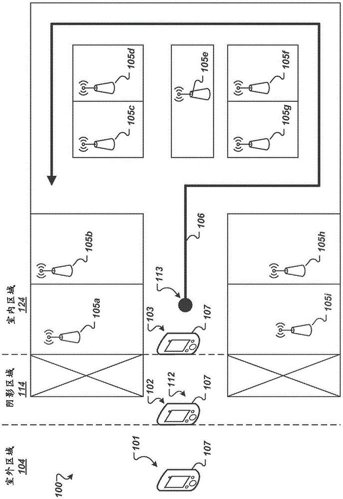
[0015] figure 1 is a diagram 100 illustrating an example of determining a location of a mobile device 107 as the mobile device 107 moves from an outdoor area 104 to an indoor area 124 . Diagram 100 illustrates mobile device 107 at four locations 101 , 102 , 103 , 113 . Mobile device 107 can include a Global Positioning System (GPS) receiver as well as a Wireless Local Area Network (WLAN) transceiver. A GPS receiver can sample signals from one or more GPS satellites. WLAN transceivers may measure signals transmitted by WLAN access points 105a-105i. The access points 105a-105i can be access points of a WiFi network implementing an Institute of Electrical and Electronics Engineers (IEEE) 802.11 based protocol (eg, IEEE802.11n). Access points 105a-105i are capable of broadcasting beacon signals that provide identifiers (e.g., Medium Access Control (MAC) addresses) for mobile devices 107 when they are within communication range of access points 105a-105i 107 is connected to it...


PUM


Abstract

The present disclosure provides a method for determining a real-time position of a mobile device using a global positioning system (GPS) and wireless local area network (WLAN) hybrid positioning mode. The method includes determining, by a mobile device, the mobile devices environment area based on GPS satellite signals; determining an absolute position of the mobile device based on the GPS satellite signals while the mobile device is moving from an outdoor area to an indoor area; estimating a reference position of the mobile device based on the determined absolute position and WLAN access point signals while moving to a shadow area; and while moving to an indoor area, determining an estimated position of the mobile device based on calculated regressive coefficients and the WLAN access point signals, and updating the estimated position of the mobile device based on motion information and indoor floor map information.

Description

[0001] Cross References to Related Applications [0002] This disclosure claims priority under 35 U.S.C. rights, their disclosures are hereby incorporated by reference in their entirety. technical field [0003] The present disclosure relates to determining the real-time location of a mobile device. Background technique [0004] Mobile devices can include one or more location-aware applications configured to perform location-based tasks, such as store finding and transit routing. Location-aware applications can determine the location of the mobile device using a satellite positioning system receiver in the mobile device to specify the real-time location of the mobile device based solely on signals from the satellites. Satellite-based positioning can provide high accuracy, but may require a positive line of sight between the satellite and the mobile device. In outdoor areas where satellite positioning signals are barely blocked, mobile devices can receive sufficient line-...

Claims


Application Information

Patent Timeline
IPC IPC(8): G01S19/00H04W4/02H04W4/029
CPCG01S19/48H04W64/00H04W4/02G01S5/012G01S5/017H04W4/029
Inventor 刘柏池贾志科周发根陈剑虞婧
Owner MARVELL ASIA PTE LTD
Why Eureka
Try Eureka