Cloud-based indoor and outdoor map building method and device, electronic equipment, and computer program product

An indoor and outdoor, cloud-based technology, applied in the field of positioning and navigation, can solve the problems of poor positioning accuracy and inability to apply across places, and achieve high positioning accuracy and simple implementation.

Inactive Publication Date: 2018-08-24
CLOUDMINDS BEIJING TECH CO LTD
View PDF5 Cites 13 Cited by
  • Summary
  • Abstract
  • Description
  • Claims
  • Application Information

AI Technical Summary

Problems solved by technology

[0004] In view of this, the embodiment of the present invention expects to provide a cloud-based indoor and outdoor mapping method, device, electronic equipment and computer program products, the purpose of which is to solve the limitations of the current single sensor positioning technology, which cannot be applied across places, resulting problem with poor accuracy

Method used


Image

  • Cloud-based indoor and outdoor map building method and device, electronic equipment, and computer program product
  • Cloud-based indoor and outdoor map building method and device, electronic equipment, and computer program product
  • Cloud-based indoor and outdoor map building method and device, electronic equipment, and computer program product

Examples


Embodiment 1

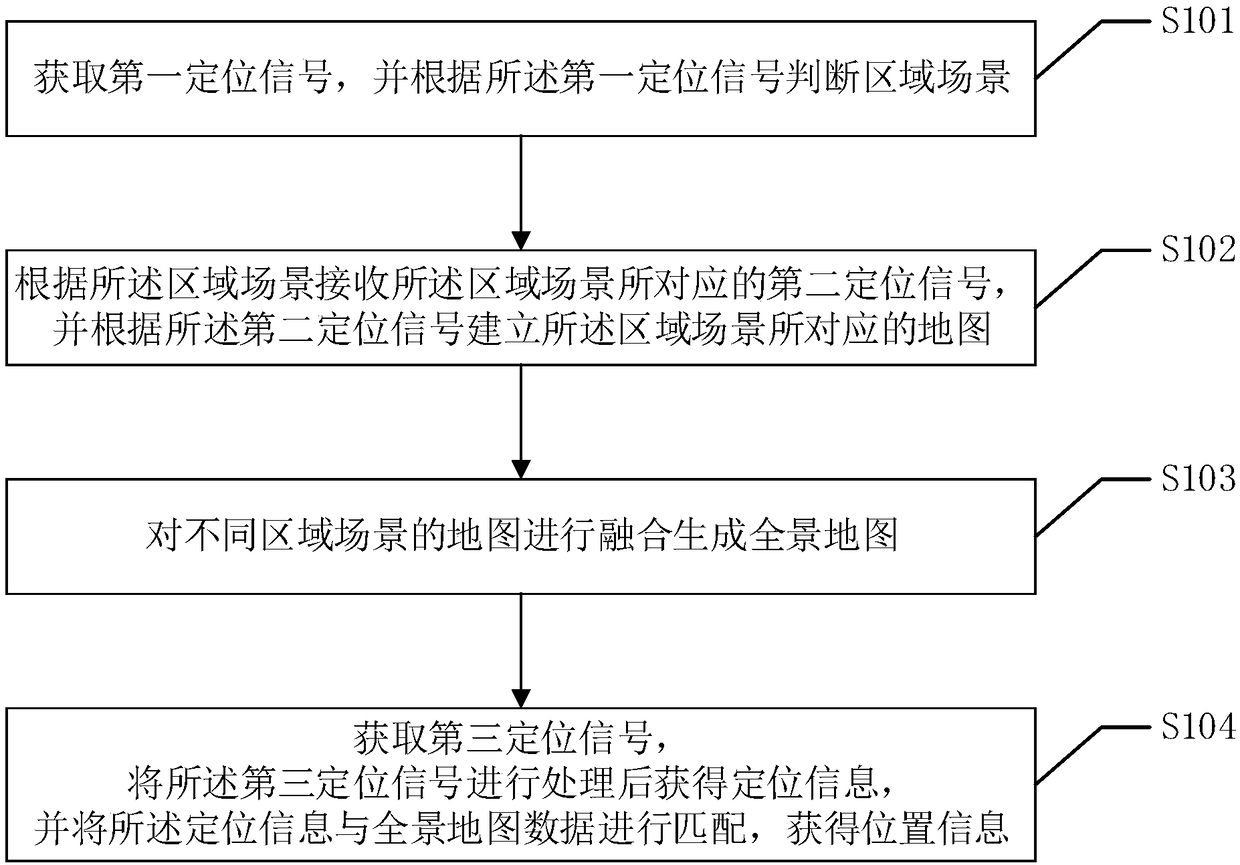
[0026] Such as figure 1 As shown, this embodiment proposes a cloud-based indoor and outdoor mapping method, which can be executed on the cloud, and the specific implementation process of the method is as follows:

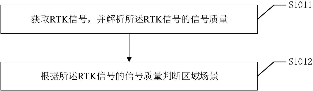
[0027] S101. Acquire a first positioning signal, and judge an area scene according to the first positioning signal.

[0028] Specifically, the cloud-based indoor and outdoor mapping method described in this embodiment is a multi-sensor fusion technology proposed to solve the problem that single sensor positioning has limitations in reality and cannot be applied across locations. Therefore, the first positioning signal acquired in the method described in this embodiment is an RTK signal, and the second positioning signal includes one or more of RTK signals, IMU signals, WIFI signals or Bluetooth signals. Correspondingly, the RTK signal is sent by a high-precision positioning module with GPS positioning function, the IMU signal is sent by an IMU (instant messenger's ...

Embodiment 2

[0066] Such as Figure 4 As shown, this embodiment proposes a cloud-based indoor and outdoor mapping device, which includes:

[0067] a positioning module, configured to send a first positioning signal and a second positioning signal to the processor;

[0068] A processor configured with processor-executable operational instructions to perform the following operations:

[0069] Acquiring a first positioning signal, and judging an area scene according to the first positioning signal;

[0070] receiving a second positioning signal corresponding to the regional scene according to the regional scene, and establishing a map corresponding to the regional scene according to the second positioning signal;

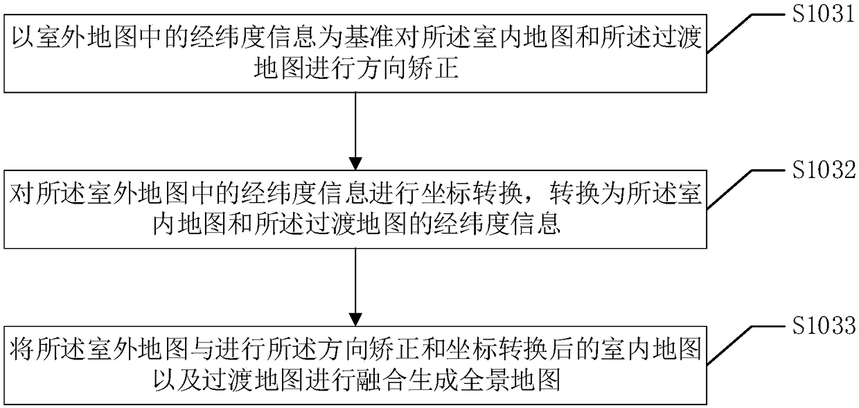
[0071] The maps of different regional scenes are fused to generate a panoramic map.

[0072] Specifically, the positioning module and the processor in the device described in this embodiment can be respectively set in the client and the cloud, that is, the client carries a devic...

Embodiment 3

[0121] This embodiment proposes an electronic device, the electronic device includes: a display, a memory, one or more processors; and one or more modules, the one or more modules are stored in the memory, and Configured to be executed by the one or more processors, the one or more modules include instructions for executing each step in the cloud-based indoor and outdoor mapping method as described above.


PUM


Abstract

The embodiment of the invention provides a cloud-based indoor and outdoor map building method, and the method comprises the steps: acquiring a first positioning signal, and determining an area scene according to the first positioning signal, wherein the area scene includes an outdoor area, a transition area, and an indoor area; receiving a second positioning signal corresponding to the area sceneaccording to the area scene, and establishing a map corresponding to the area scene according to the second positioning signal; and combining the maps of the different area scenes to generate a panoramic map. The embodiment of the invention also provides a cloud-based indoor and outdoor map building device. According to the invention, the method and device can effectively solve problems that the indoor and outdoor map building and positioning fusion are difficult, and can be used for the positioning and navigation of a pedestrian or a robot.

Description

technical field [0001] The present invention relates to the field of positioning and navigation, in particular to a cloud-based indoor and outdoor mapping method, device, electronic equipment and computer program product. Background technique [0002] Ubiquitous positioning technology is a key technology and application. With the development of mobile Internet, location-based services have penetrated into every aspect of people's lives. The common positioning methods mainly include: GPS positioning, WIFI positioning, Bluetooth positioning, etc. The positioning methods using a single mode have their own advantages and disadvantages. The applicable scenarios, positioning accuracy, real-time performance, power consumption, and use cost of positioning are different. [0003] GPS (Global Positioning System, Global Positioning System) can provide high-precision positioning (5-10m) outdoors. With the help of differential technology (RTK, Real-time kinematic), its positioning accura...

Claims


Application Information

Patent Timeline
Patent Type & Authority Applications(China)
IPC IPC(8): G01S19/48G01S19/49G06F17/30
CPCG01S19/48G01S19/49G06F16/29
Inventor 王超鹏廉士国林义闽
Owner CLOUDMINDS BEIJING TECH CO LTD
Why Eureka
Try Eureka