Movable mapping platform

A mobile surveying and mapping and platform technology, applied in surveying and navigation, surveying devices, photogrammetry/video metrology, etc., can solve the problems of inability to meet the needs of popularization, low resolution, high cost, etc., to reduce complexity and operation Effects of cost reduction, computation load reduction, and system cost reduction

Inactive Publication Date: 2016-03-23
CHANGGUANG SATELLITE TECH CO LTD
View PDF5 Cites 7 Cited by
  • Summary
  • Abstract
  • Description
  • Claims
  • Application Information

AI Technical Summary

Problems solved by technology

[0006] The present invention provides a mobile surveying and mapping platform to solve the problems of low resolution in the existing surveying and mapping technology and the need to use it in combination with other surveying and mapping products, resulting in high cost and failure to meet the needs of popularization.

Method used


Image

  • Movable mapping platform
  • Movable mapping platform
  • Movable mapping platform

Examples


specific Embodiment approach 1

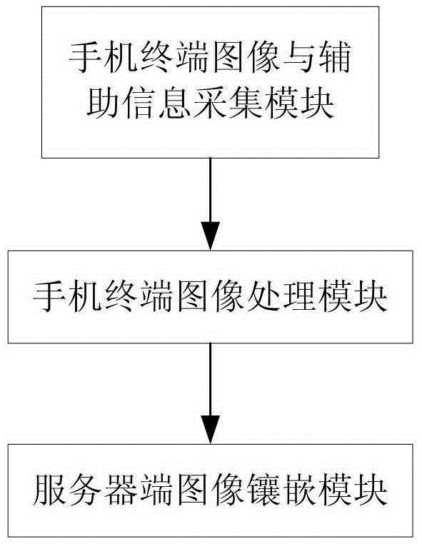
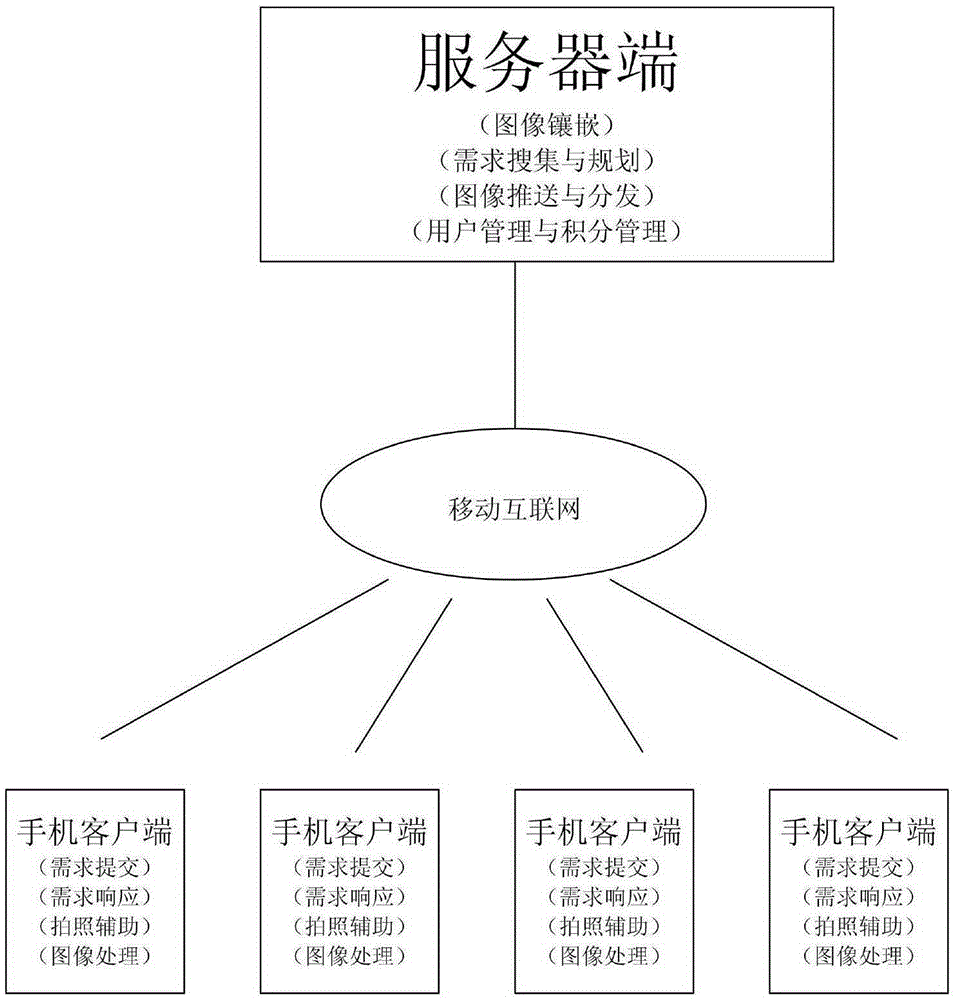
[0017] Specific implementation mode 1. Combination Figure 1 to Figure 5 Describe this embodiment, a mobile surveying and mapping platform, which uses a smart phone as a surveying and mapping terminal, acquires and completes image processing, uploads it to the server, and mosaics the global surveying and mapping map, including a mobile terminal image and auxiliary information collection module, and a mobile terminal image processing module module and server-side image mosaic module; the specific implementation is:

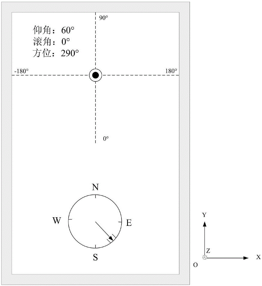
[0018] 1. Mobile terminal image and auxiliary information collection module: combined figure 2 , in order to obtain images that meet the needs, the interface of the mobile APP displays three auxiliary tools: In order to describe the camera coordinate system, define the camera optical axis to point to the positive Z-axis direction, the horizontal direction (short side direction) of the mobile phone screen to be the X direction, and the vertical direction ( The dir...


PUM


Abstract

The invention relates to a movable mapping platform which is used for carrying out mapping image collecting and processing by utilizing a smart phone, and carrying out distributing, sharing and business requests by utilizing a cloud service platform, and solves the problems existing in an existing mapping technology that the resolution is low, and the existing mapping technology needs to be combined with other mapping products for use, so that the cost is high, mass needs cannot be met, and the like. The movable mapping platform comprises a mobile phone terminal image and auxiliary information collection module, a mobile phone terminal image processing module and a server side image mosaicking module, wherein the smart phone is adopted as a mapping terminal, an APP (Application) with a photographing function is installed in the smart phone, the APP with the photographing function is used for obtaining an image, processing the image and uploading the processed image to a server. According to the movable mapping platform disclosed by the invention, the smart phone is adopted as the mapping terminal, so that the system cost can be substantially reduced; meanwhile, a complete mapping map after seamless mosaicking is provided for a user.

Description

technical field [0001] The invention relates to a mobile surveying and mapping platform that uses a smart phone to collect and process surveying and mapping images, and utilizes a cloud service platform to distribute, share and service requests. Background technique [0002] Traditional urban surveying and mapping mainly has the following technical approaches: Manual surveying and mapping is the field work of surveyors and mappers through professional surveying and mapping instruments to obtain high-precision surveying and mapping data. The designated area is imaged by aircraft (mainly drones in recent years), and then the surveying and mapping image is obtained through image processing. Compared with manual surveying and mapping, its efficiency is greatly improved, the resolution is high, and the surveying and mapping area is wide. Surveying and mapping uses satellites for global imaging, which has the advantages of high light and high efficiency in the surveying and mappin...

Claims


Application Information

Patent Timeline
Patent Type & Authority Applications(China)
IPC IPC(8): G01C11/00H04M1/725G06F17/30G06Q30/02
CPCG01C11/00G06Q30/0217G06F16/29G06F16/9537H04M1/724
Inventor 贺小军
Owner CHANGGUANG SATELLITE TECH CO LTD
Why Eureka
Try Eureka