Supercharge Your Innovation With Domain-Expert AI Agents!

A Method for Drawing Power Grid Geographic Wiring Diagram Based on Aerial Image Recognition

A technology of geographic wiring diagrams and aerial images, applied in character and pattern recognition, instruments, calculations, etc., can solve problems such as prone to errors, inaccurate positions, and labor and material resources, and achieve the effect of improving efficiency and accuracy

Inactive Publication Date: 2018-10-16
YANTAI POWER SUPPLY COMPANY OF STATE GRID SHANDONG ELECTRIC POWER +2
View PDF8 Cites 0 Cited by
  • Summary
  • Abstract
  • Description
  • Claims
  • Application Information

AI Technical Summary

Problems solved by technology

[0002] The traditional geographic wiring diagram of the power grid is manually drawn by experienced grid planners. This method is inefficient, consumes a lot of manpower and material resources, and the location is not accurate, and it is prone to errors

Method used


Image

  • A Method for Drawing Power Grid Geographic Wiring Diagram Based on Aerial Image Recognition
  • A Method for Drawing Power Grid Geographic Wiring Diagram Based on Aerial Image Recognition
  • A Method for Drawing Power Grid Geographic Wiring Diagram Based on Aerial Image Recognition

Examples


Embodiment

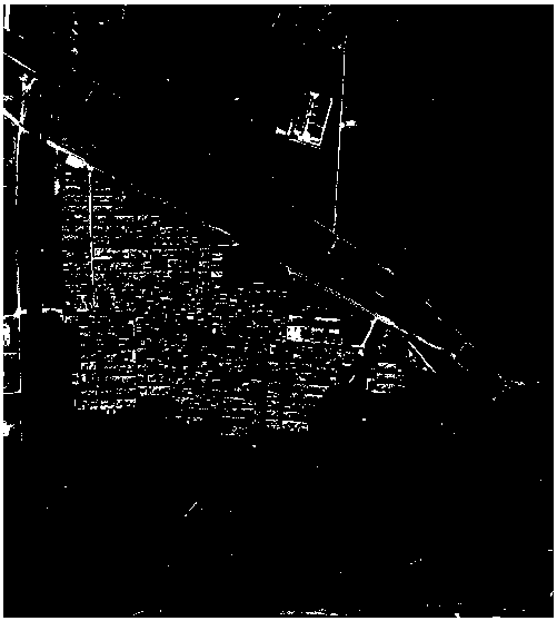
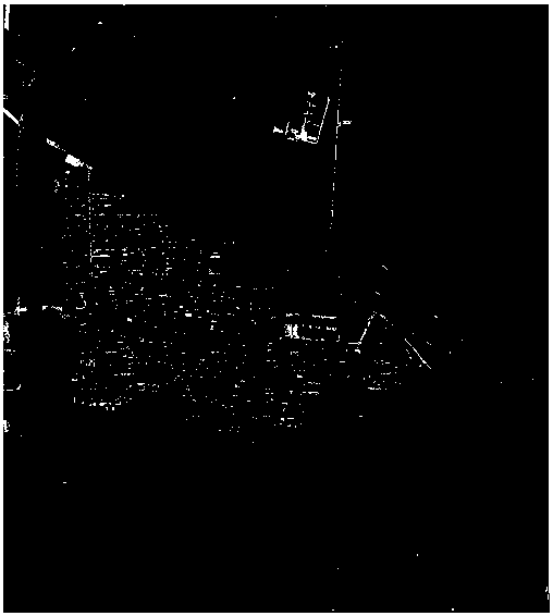
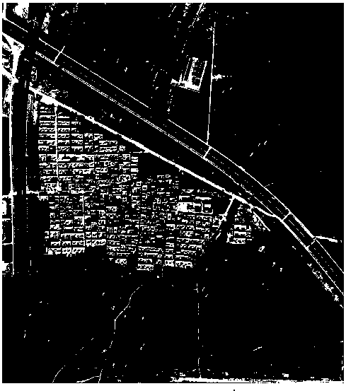
[0051] Embodiment: A method for drawing geographical wiring diagrams of power grids based on aerial image recognition (see Figure 1-Figure 9 ), the specific steps are as follows:

[0052] Step 1. Select the eigenvalues ​​of substations and towers according to the design scheme of the typical design manual of the State Grid, and then use the "least square method" to fit the eigenvalues ​​of substations and towers. For example, it can be identified by the tower shape, insulator string length, and wire information such as cat head pole tower, gate tower, wine glass tower, dry font tower, Crimean tower, upper font tower, single column tower, catenary tower, etc. Tower and voltage level; identify the substation and voltage level through the color, shape, size, floor plan, lightning rod, and transformer of the substation. The eigenvalues ​​are then made into templates.

[0053] Step 2. Use satellites or unmanned aerial vehicles to shoot the area where the geographic wiring diagra...


PUM


Abstract

The invention discloses a method for drawing a geographical wiring diagram of a power grid based on aerial image recognition, which selects the characteristic values ​​of substations and towers, and performs fitting to make a template; intercepts image frames from aerial video; performs grayscale conversion on the image; and performs histogram Image equalization is strengthened; binarization effect map is obtained; denoising effect map is obtained; foreground image containing only edge information is obtained; graphic contours of suspected substations and towers are obtained; the extracted edge contour information is compared with the characteristic templates of substations and towers Matching, successful matching and marking; draw the key point connections of substations or towers on the geographical wiring diagram of the power grid; manually check the geographical wiring diagram of the power grid; the invention has high efficiency, accurate position, low error rate, and saves manpower and material resources. The automatic computer drawing greatly improves the efficiency and accuracy of drawing the geographic wiring diagram of the power grid.

Description

Technical field: [0001] The invention relates to a method for drawing a geographical wiring diagram of a power grid, in particular to a method for drawing a geographical wiring diagram of a power grid based on aerial image recognition. Background technique: [0002] The traditional geographic wiring diagram of the power grid is manually drawn by experienced grid planners. This method is inefficient, consumes a lot of manpower and material resources, and the location is inaccurate, and it is prone to errors. Invention content: [0003] The purpose of the present invention is to overcome the deficiencies of the above-mentioned prior art and provide a flexible, convenient, efficient, accurate and practical method for drawing geographical wiring diagrams of power grids based on aerial image recognition. [0004] The object of the present invention can be achieved through the following measures: a method for drawing a power grid geographic wiring diagram based on aerial image r...

Claims


Application Information

Patent Timeline
Patent Type & Authority Patents(China)
IPC IPC(8): G06K9/00
CPCG06V20/176
Inventor 宋峰吴雷平廉伟张明耀徐桢刘杰康凯张婷婷曹检德田书然刘俊旭吕卫民
Owner YANTAI POWER SUPPLY COMPANY OF STATE GRID SHANDONG ELECTRIC POWER
Features
  • R&D
  • Intellectual Property
  • Life Sciences
  • Materials
  • Tech Scout
  • Unparalleled Data Quality
  • Higher Quality Content
  • 60% Fewer Hallucinations
Learn More