A new tavi terrain adjustment factor optimization algorithm

A technology of adjusting factors and optimization algorithms, applied in radio wave measurement systems, instruments, etc., can solve problems such as limiting the automation level of TAVI application and unfavorable TAVI popularization and application, achieving obvious terrain correction effect, minimizing data cost and time cost, The effect of eliminating the interference of vegetation information

Active Publication Date: 2018-02-09
FUZHOU UNIV
View PDF2 Cites 0 Cited by
  • Summary
  • Abstract
  • Description
  • Claims
  • Application Information

AI Technical Summary

Problems solved by technology

However, both of these two optimization algorithms need to classify remote sensing images, and the "optimal matching" algorithm also needs the support of ground data, which limits the automation level of TAVI applications and is not conducive to the promotion and application of TAVI

Method used


Image

  • A new tavi terrain adjustment factor optimization algorithm
  • A new tavi terrain adjustment factor optimization algorithm
  • A new tavi terrain adjustment factor optimization algorithm

Examples


Embodiment Construction

[0032] The present invention will be further described below in conjunction with the accompanying drawings and embodiments.

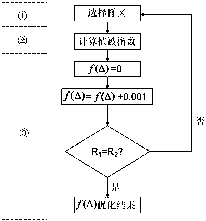
[0033] Please refer to figure 1 , the present invention provides a kind of novel TAVI terrain adjustment factor optimization algorithm, it is characterized in that comprising the following steps:

[0034] Step S1: Select a sample area, select a typical sample area in a mountainous area with complex terrain, and ensure that the image of the sample area in the typical sample area has the least noise interference, has a strong terrain influence, and the sunny and shady slopes of the mountain are basically symmetrically distributed. The optimal area of ​​the sample area is 2*2 square kilometers;

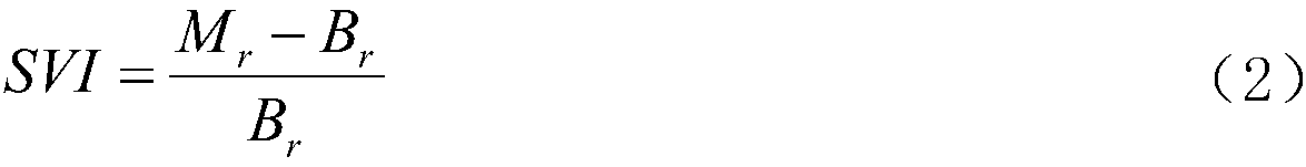
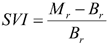
[0035] Step S2: Calculate the vegetation index, specifically as follows:

[0036] TAVI=CVI+f(Δ)·SVI

[0037]

[0038] Among them: TAVI is terrain-adjusted vegetation index; CVI is conventional vegetation index; SVI is shaded vegetation index; f(Δ) is terrain...


PUM


Abstract

The invention relates to a novel optimization algorithm of the TAVI topography adjusting factor. The algorithm comprises the following steps of selecting a sample zone, calculating the vegetation index, calculating the correlation coefficient, and approaching optimization. The algorithm neither need DEM data and remote sensing image classification nor rely on ground investigation data, and the algorithm has high scientific and economic values in applying and popularizing TAVI in accurate inversion of vegetation information of mount area of complex topography.

Description

technical field [0001] The invention relates to a novel TAVI terrain adjustment factor optimization algorithm. Background technique [0002] There are two main optimization methods for the terrain adjustment factor f(Δ) in the existing terrain-adjusted vegetation index (TAVI, formula 1, formula 2, national patent number 200910111688.X): "matching optimization method" and "extreme value optimization method" . [0003] TAVI=CVI+f(Δ) SVI (1) [0004] [0005] In the formula, CVI is the conventional vegetation index, such as normalized difference vegetation index (NDVI), ratio vegetation index (RVI), etc.; SVI is the shaded vegetation index, where B r Represents remote sensing image red light band data, M r Indicates the maximum value of the red light band data; f(Δ) is the terrain adjustment factor. [0006] The calculation steps of the "optimal matching" algorithm are: (1) image classification, dividing the shady and sunny slopes of the mountain in remote sensing images...

Claims


Application Information

Patent Timeline
Patent Type & Authority Patents(China)
IPC IPC(8): G01S7/48
CPCG01S7/48
Inventor 江洪汪小钦陈芸芝
Owner FUZHOU UNIV
Why Eureka
Try Eureka