Satellite positioning acquiring device based patrol state displaying method and device

A technology for inspecting status and collecting equipment, applied in registration/indication, inspection time patrol, recording/indicating the time of events, etc., can solve problems such as difficulty in judgment, and achieve the effect of easy judgment

Active Publication Date: 2016-05-04
深圳市中燃科技有限公司
View PDF6 Cites 2 Cited by
  • Summary
  • Abstract
  • Description
  • Claims
  • Application Information

AI Technical Summary

Problems solved by technology

[0002] Discovering hidden dangers in natural gas pipelines and equipment, handling hidden dangers, and checking the handling of hidden dangers are the most important safety tasks, and they all work outdoors. The current traditional management method is: after the inspection personnel go to the outdoor inspection to find hidden dangers, they will contact them by phone, etc. Report the hidden danger information in detail, and record the hidden danger situation through paper documents. Then, according to the situation described by the inspectors, the management personnel will arrange emergency repair personnel to rush to the location where the equipment is placed for emergency repair. After the emergency repair is completed, the emergency repair situation will be recorded through paper documents. and the results, and bring all the paper documents back to the company for archiving and statistics; there is also a method of displaying the inspection track on the electronic map by connecting the geographical coordinates collected by the satellite positioning instrument into a line, but this method can only be used for It is difficult to judge whether the state of the positioning instrument, the state of the network transmission device, and the change of the position of the person or object are normal by viewing, analyzing, and applying the trajectory.

Method used


Image

  • Satellite positioning acquiring device based patrol state displaying method and device
  • Satellite positioning acquiring device based patrol state displaying method and device
  • Satellite positioning acquiring device based patrol state displaying method and device

Examples


Embodiment 1

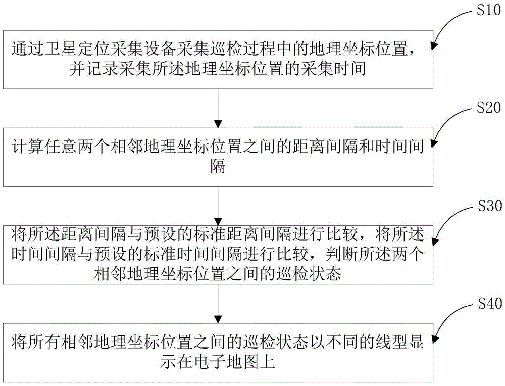
[0046] figure 1 It is a flow chart of a method for displaying inspection status based on satellite positioning acquisition equipment provided by Embodiment 1 of the present invention.

[0047] A method for displaying inspection status based on satellite positioning acquisition equipment, comprising:

[0048] S10. Collect the geographic coordinate position during the inspection process through the satellite positioning acquisition device, and record the acquisition time for acquiring the geographic coordinate position;

[0049] S20. Calculate the distance interval and time interval between any two adjacent geographical coordinate positions;

[0050] S30. Comparing the distance interval with a preset standard distance interval, comparing the time interval with a preset standard time interval, and judging the inspection status between the two adjacent geographic coordinate positions;

[0051] S40. Display the inspection status between all adjacent geographic coordinate position...

Embodiment 2

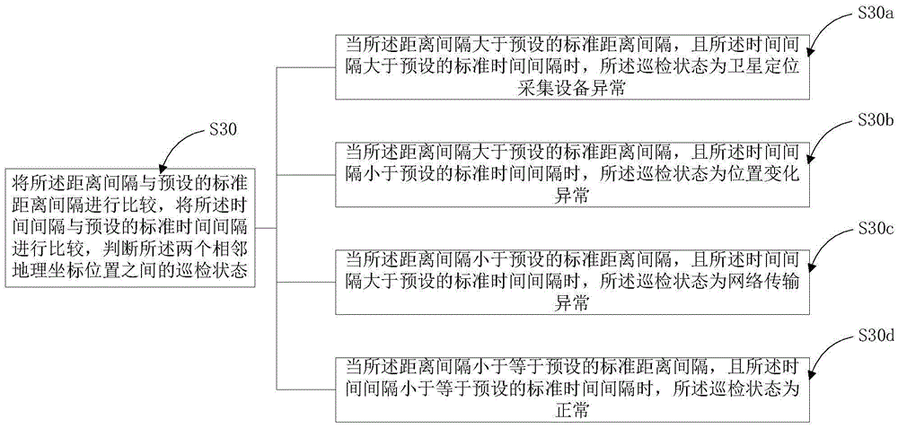
[0055] Such as figure 2 As shown, in this embodiment, the step S30 includes:

[0056] S30a. When the distance interval is greater than the preset standard distance interval and the time interval is greater than the preset standard time interval, the inspection state is that the satellite positioning acquisition equipment is abnormal;

[0057] S30b. When the distance interval is greater than a preset standard distance interval and the time interval is smaller than a preset standard time interval, the inspection status is an abnormal position change;

[0058] S30c. When the distance interval is less than a preset standard distance interval and the time interval is greater than the preset standard time interval, the inspection status is abnormal network transmission;

[0059] S30d. When the distance interval is less than or equal to a preset standard distance interval, and the time interval is less than or equal to a preset standard time interval, the inspection status is normal....

Embodiment 3

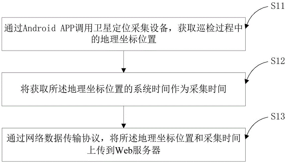
[0062] Such as image 3 As shown, in this embodiment, the step S10 includes:

[0063] S11. Call the satellite positioning acquisition device through the Android APP to obtain the geographic coordinate position during the inspection process;

[0064] S12. Use the system time for acquiring the geographic coordinate position as the collection time;

[0065] S13. Upload the geographical coordinate position and collection time to the Web server through the network data transmission protocol.

[0066] In this embodiment, the Android APP is an APP specially used for pipeline inspection. The APP has a collection function, an upload function, and a camera function. It can call a satellite positioning collection device to collect geographic coordinates. The on-site equipment takes pictures and uploads them to the Web server; after the WEB server receives the geographic coordinate position and the collection time, it calculates the distance interval and time interval and compares them ...


PUM


Abstract

The invention relates to the technical field of gas pipeline patrol, and particularly relates to a satellite positioning acquiring device based patrol state displaying method and device. The method comprises: acquiring the geographical coordinate position in a patrol process by the satellite positioning acquiring device, and recording the acquiring time; calculating the distance interval and the time interval between any two adjacent geographical coordinate positions; comparing the distance interval with the preset standard distance interval, comparing the time interval with the preset standard time interval, and judging the patrol state between the two adjacent geographical coordinate positions; and displaying the patrol states of all adjacent geographical coordinate positions on an electronic map in different line types. According to the invention, the states of the satellite positioning acquiring device and the patrol people carrying the device can be judged by judging the distance and time between the adjacent geographical coordinate positions, and are displayed visually on the electronic map via different line types so as to judge the patrol quality definitely by management personnel.

Description

technical field [0001] The invention relates to the technical field of inspection of gas pipelines, in particular to a method and device for displaying inspection status based on satellite positioning acquisition equipment. Background technique [0002] Discovering hidden dangers in natural gas pipelines and equipment, handling hidden dangers, and checking the handling of hidden dangers are the most important safety processing tasks, and they are all outdoor work. The current traditional management method is: after the inspection personnel go to the outdoor inspection to find hidden dangers, they will call and etc. Report the hidden danger information in detail, and record the hidden danger situation through paper documents. Then, according to the situation described by the inspectors, the management personnel will arrange emergency repair personnel to rush to the location where the equipment is placed for emergency repair. After the emergency repair is completed, the emergen...

Claims


Application Information

Patent Timeline
Patent Type & Authority Applications(China)
IPC IPC(8): G07C1/20G07C1/10
CPCG07C1/10G07C1/20
Inventor 毛文光荣建新王兴杰王军李虹霖
Owner 深圳市中燃科技有限公司
Why Eureka
Try Eureka