Electronic map road rendering method and apparatus

A technology of electronic maps and roads, applied in maps/plans/charts, instruments, educational tools, etc., can solve the problems of reducing processing efficiency, increasing response delay of electronic maps, and resource consumption of electronic map engines, so as to improve processing efficiency, The effect of reducing processing resource consumption and reducing response delay

Active Publication Date: 2016-05-11
ALIBABA (CHINA) CO LTD
View PDF12 Cites 16 Cited by
  • Summary
  • Abstract
  • Description
  • Claims
  • Application Information

AI Technical Summary

Problems solved by technology

[0006] It can be seen that in the rendering process of the existing electronic map roads, when the electronic map engine performs coordinate transformation on the vertex coordinates of each vertex of the road contained in the electronic map to be displayed to obtain relative coordinates, since the coordinates of the center point of the electronic map to be displayed Real-time changes make the electronic map engine need to determine in real time the relative coordinates of the vertex coordinates of each vertex of the road contained in the electronic map to be displayed. On the one hand, it causes the processing resource consumption of the electronic map engine; Response delays, reducing processing efficiency

Method used


Image

  • Electronic map road rendering method and apparatus
  • Electronic map road rendering method and apparatus
  • Electronic map road rendering method and apparatus

Examples


Embodiment Construction

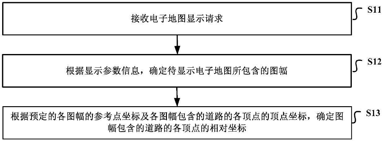
[0023] In order to reduce the consumption of processing resources of the electronic map engine in the process of rendering the electronic map, reduce the response delay of the rendering of the electronic map, and improve the rendering efficiency of the electronic map, the embodiments of the present invention provide a road rendering method and device for the electronic map.

[0024] The preferred embodiments of the present invention will be described below in conjunction with the accompanying drawings. It should be understood that the preferred embodiments described here are only used to illustrate and explain the present invention, and are not intended to limit the present invention, and in the absence of conflict, the present invention The embodiments and the features in the embodiments can be combined with each other.

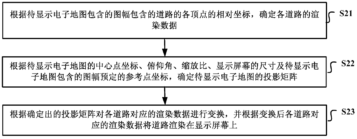
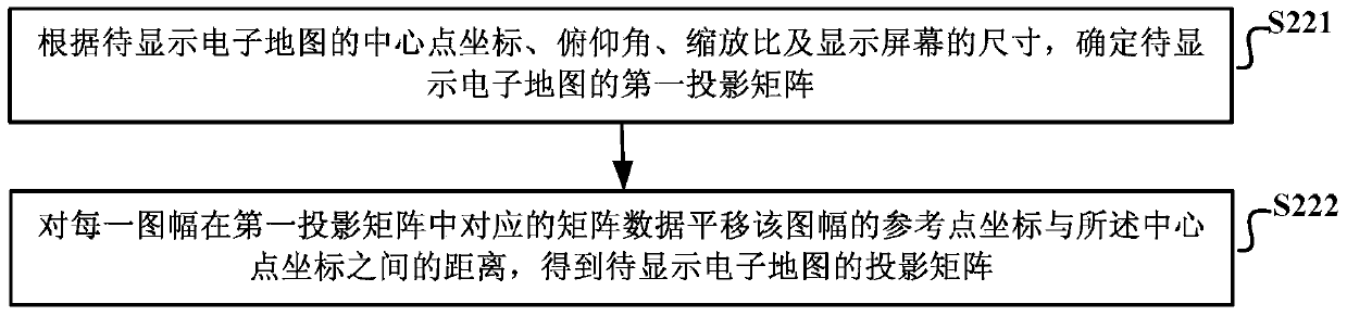
[0025] like figure 1 As shown, it is a schematic diagram of the implementation flow of the electronic map road rendering method provided by the embodiment ...


PUM


Abstract

The invention discloses an electronic map road rendering method and apparatus. The objective of the invention is to reduce the consumption of the processing resources of an electronic map engine, reduce response delay in an electronic map rendering process and improve processing efficiency. The electronic road map rendering method includes the following steps that: an electronic map display request is received, wherein the electronic map display request carries display parameter information; pictures contained in an electronic map to be displayed are determined according to the display parameter information; and relative coordinates of vertexes of roads contained in the pictures are determined according to the coordinates of preset reference points of the pictures and the vertex coordinates of the vertexes of the roads contained in the pictures.

Description

technical field [0001] The present invention relates to the technical field of electronic maps, in particular to a road rendering method and device for electronic maps. Background technique [0002] An electronic map is a digital map, which is a map that is stored and consulted digitally using computer technology. electronically Figure 1 Generally, vector image storage is used, and the map scale can be enlarged, reduced or rotated without affecting the display effect. [0003] In the rendering process of electronic map roads, in order to meet the display requirements of terminal equipment display accuracy and aesthetics, it is necessary to convert the vertex coordinates of the road (usually longitude and latitude data) according to certain algorithms, such as anti-aliasing and stroke coordinate conversion Wait. Wherein, a vertex refers to a point on a road where the direction changes, and each road may contain multiple vertices. [0004] In the prior art, when a terminal...

Claims


Application Information

Patent Timeline
Patent Type & Authority Applications(China)
IPC IPC(8): G09B29/00
Inventor 吴朝良林燕腾陈其义
Owner ALIBABA (CHINA) CO LTD
Why Eureka
Try Eureka