Optimal recognition method for urban public transport system using taxi gps data

A technology based on GPS data and urban public transport, applied in the field of optimal identification of urban public transport systems, can solve the problems of not being able to reflect residents, not being able to point out the optimization of the public transport system, and not in-depth investigation of the travel needs of residents, etc., to achieve more scientific and operable , overcoming one-sidedness and limited effects

Active Publication Date: 2017-11-10
HOHAI UNIV +1
View PDF5 Cites 0 Cited by
  • Summary
  • Abstract
  • Description
  • Claims
  • Application Information

AI Technical Summary

Problems solved by technology

These two types of index evaluation methods are overall positive evaluations of the comprehensive service efficiency of the established public transport system, and neither of them has deeply investigated the travel needs of residents under the current urban spatial layout environment, especially the residents who cannot take public transport. The demand cannot reflect the gap between the planning of the bus operation system and the needs of residents, and it cannot point out the location of the bus demand and the section of the bus station that needs to be enhanced for the bus system optimization.

Method used


Image

  • Optimal recognition method for urban public transport system using taxi gps data
  • Optimal recognition method for urban public transport system using taxi gps data
  • Optimal recognition method for urban public transport system using taxi gps data

Examples


Embodiment Construction

[0046] The present invention will be further elaborated below by describing a preferred specific embodiment in detail in conjunction with the accompanying drawings.

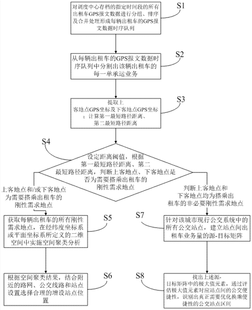
[0047] Such as figure 1 As shown, a method for optimizing the identification of urban public transport systems using taxi GPS data, the optimal identification method includes:

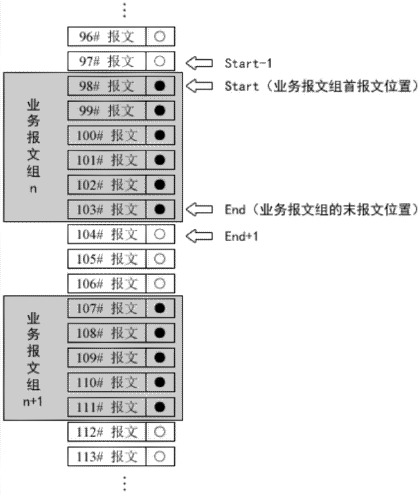
[0048] S1, grouping, sorting and merging the GPS message data of all taxis in the city acquired by the dispatch center every day to form a time-series queue of GPS message data for each taxi. The step S1 includes:

[0049] In this embodiment, due to the huge amount of data, most of the taxi GPS message data is archived in the form of disk files. For example, the dispatch center generates an archive file every day to record all the GPS message data uploaded by all taxis on the same day.

[0050] S1.1, according to the taxi identification codes in all taxi GPS message data in each archive file of the dispatch center, group all GPS message...


PUM


Abstract

The invention discloses a method for carrying out optimal identification on an urban public transportation system by use of taxi GPS data. The method comprises steps of obtaining rigid demand places and non-rigid demand places of multiple taxi pick-up points of taxis; carrying out space cluster analysis on the rigid demand places so as to obtain outstanding clustering regions and selecting a newly added stop position comparing a current public transportation system; and identifying unnecessary taxi businesses, counting up unnecessary taxi business quantity among all bus stations, constructing taxi business quantity source-target matrixes among the bus stations; and identifying bus station regions where transferring convenience should be truly optimized. According to the invention, by adopting an analysis means of a geographic information system, taxi pick-up and drop-off hot regions are excavated from mass data of urban taxi GPS and operation states; and by comparing route planning and station distribution of public transportation systems, design defects for resident requirements in public transportation systems in a current urban spatial layout are identified and decision basis is provided for optimization and construction of urban public transportation systems.

Description

technical field [0001] The invention relates to the field of urban taxi operation data mining and application, in particular to a method for optimizing and identifying urban public transport systems using taxi GPS data. Background technique [0002] Taxi is a free-flowing traffic carrier in the city. There is no fixed operating route and pick-up and drop-off stations, and it can walk freely in the city to find passengers and reach the destination directly. It has the highest convenience in urban public transportation. However, the consumption price of taxis is also significantly higher than that of regular public transportation such as buses and subways. For most city dwellers, taxis are an alternative when cheap fixed-route public transport cannot meet the needs of accessibility. Therefore, taxis are a necessary supplement to the fixed-line bus system, and undertake the transportation tasks of residents beyond the capacity of the fixed-line bus system. [0003] With the d...

Claims


Application Information

Patent Timeline
Patent Type & Authority Patents(China)
IPC IPC(8): G08G1/01
CPCG08G1/0129G08G1/0137
Inventor 李嘉廖威蓝秋萍邓辉林欢田青红汪子豪
Owner HOHAI UNIV
Why Eureka
Try Eureka