Method for reporting GPS data during vehicle curve running and vehicle-mounted GPS

A GPS data, running technology, applied in the field of vehicle GPS, can solve problems such as poor user experience, achieve the effect of improving response speed, enhancing user physical examination, and reducing memory dependence

Inactive Publication Date: 2016-06-15
BEIJING ZHUOSHIDA SOFTWARE CO LTD
View PDF7 Cites 3 Cited by
  • Summary
  • Abstract
  • Description
  • Claims
  • Application Information

AI Technical Summary

Problems solved by technology

[0004] The inventor found in the research that the time interval for the vehicle-mounted GPS to report the collected GPS data to the server is generally a fixed value, such as 30 seconds, but when the vehicle encounters a curve or a bridge, this method of reporting GPS data It will make the display end show that the vehicle running track directly crosses the road or bridge hole, making the user experience relatively poor

Method used


Image

  • Method for reporting GPS data during vehicle curve running and vehicle-mounted GPS
  • Method for reporting GPS data during vehicle curve running and vehicle-mounted GPS

Examples


Embodiment Construction

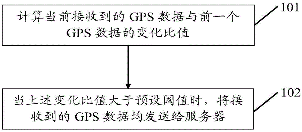
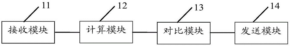
[0027] The following will clearly and completely describe the technical solutions in the embodiments of the present invention with reference to the accompanying drawings in the embodiments of the present invention. Obviously, the described embodiments are only some, not all, embodiments of the present invention. The components of the embodiments of the invention generally described and illustrated in the figures herein may be arranged and designed in a variety of different configurations. Accordingly, the following detailed description of the embodiments of the invention provided in the accompanying drawings is not intended to limit the scope of the claimed invention, but merely represents selected embodiments of the invention. Based on the embodiments of the present invention, all other embodiments obtained by those skilled in the art without making creative efforts belong to the protection scope of the present invention.

[0028] Considering that the time interval for the ve...


PUM


Abstract

The invention provides a GPS data reporting method and a vehicle-mounted GPS during vehicle curve running, and belongs to the field of vehicle-mounted terminals. The method includes: the on-vehicle GPS calculates the change ratio between the currently received GPS data and the previous GPS data; when the change ratio is greater than a preset threshold, all the received GPS data are sent to the server. The embodiment of the present invention calculates the change ratio between each GPS data and the previous GPS data. When the change ratio is greater than the threshold, it indicates that the vehicle is running on a curve. At this time, the time interval for reporting the GPS data is not considered, but the received All GPS data are reported to the server, so that the vehicle curve track displayed on the display end is more attached to the road surface, which enhances the user's physical examination.

Description

technical field [0001] The present invention relates to the field of vehicle-mounted terminals, in particular to a GPS (Global Positioning System, Global Positioning System) data reporting method and a vehicle-mounted GPS when a vehicle is running on a curve. Background technique [0002] The vehicle navigation system is an intelligent transportation system that integrates GPS, geographic information system (GIS for short) and computer technology. The GPS vehicle navigation system can realize the positioning and navigation of the vehicle, and can also implement dynamic control of the vehicle and improve the scheduling management ability. Therefore, the vehicle navigation system has been widely used in the automotive field. [0003] The vehicle navigation system includes a vehicle GPS, GSM (Global System for Mobile Communications, Global System for Mobile Communications) and a server. The vehicle-mounted GPS sends the collected GPS data to the server through GSM at an interv...

Claims


Application Information

Patent Timeline
Patent Type & Authority Applications(China)
IPC IPC(8): G01C21/36
CPCG01C21/3626
Inventor 李继亮郭玉栋高飞
Owner BEIJING ZHUOSHIDA SOFTWARE CO LTD
Why Eureka
Try Eureka