Quick land area measurement device based on unmanned aerial vehicle and measurement method thereof

A technology of land area and measuring devices, which is applied in the field of UAV aerial survey, can solve the problems of low precision and high cost of use, and achieve the effects of improving measurement precision, convenient operation and simple structure

Active Publication Date: 2016-06-22
SHANGHAI NORMAL UNIVERSITY
View PDF8 Cites 16 Cited by
  • Summary
  • Abstract
  • Description
  • Claims
  • Application Information

AI Technical Summary

Problems solved by technology

[0003] The purpose of the present invention is to overcome the disadvantages of low accuracy and high cost of use when the aerial camera measuring the land area exists in the prior art, corresponding to the boundary line of the area to be measured according to the trajectory of the flight, and to provide a drone-based The rapid land are

Method used


Image

  • Quick land area measurement device based on unmanned aerial vehicle and measurement method thereof
  • Quick land area measurement device based on unmanned aerial vehicle and measurement method thereof
  • Quick land area measurement device based on unmanned aerial vehicle and measurement method thereof

Examples


Embodiment 1

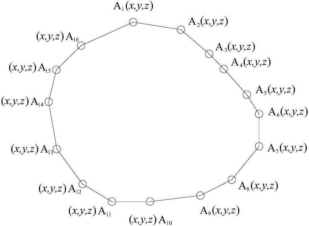
[0033] Such as figure 1 , 2 As shown, a rapid land area measurement device based on drones, including:

[0034] The unmanned aerial vehicle is provided with a positioning module for locating its own three-dimensional position information, a camera for collecting images, a height sensor for measuring its height relative to the ground, and a visible light emitting module. The visible light emitting module uses For launching vertical beams and oblique beams relative to the drone;

[0035] The application terminal includes a control system for controlling the flight of the UAV, and an image display module for displaying the measured land image and the three-dimensional position information of the UAV.

[0036] The above-mentioned positioning module is a GPS satellite navigation module, a Beidou satellite navigation module or a Galileo satellite navigation module.

[0037] In addition, the wavelengths of the vertical light beams and the oblique light beams emitted by the visible...

Embodiment 2

[0040] Such as figure 1 , 2 Shown, the present invention also provides a kind of measuring method based on the fast land area measuring device of unmanned aerial vehicle, comprises using a kind of fast land area measuring device based on unmanned aerial vehicle as in embodiment 1, and its measuring method comprises the following step:

[0041] Step 1. Start the UAV, use the control device to control the UAV to fly above the land to be measured, and control the UAV to fly to the actual boundary position of the land to be measured;

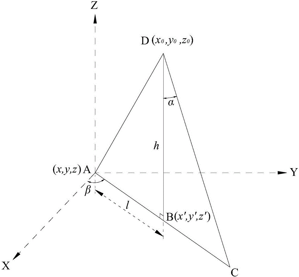
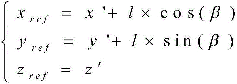
[0042] Step 2. Keep the UAV in a horizontal state, start the visible light emitting module on the UAV to emit the vertical beam and the oblique beam relative to the UAV, and the camera records the reflection of the vertical beam and the oblique beam on the surface of the land to be measured The image information of the point position, where the reflection point on the land to be measured where the vertical beam is located is the measurement point ...

Embodiment 3

[0054] The present invention also provides a measurement method based on a drone-based rapid land area measurement device, which is the same as that in Embodiment 2. The difference is that when the surface of the land to be measured is obviously not in the same level state, that is, there are large fluctuations, in order to accurately measure its surface area, after the three-dimensional coordinate information measurement of the boundary of the land to be measured in Example 2, the inside of the boundary has a large The undulating points are respectively calibrated with three-dimensional coordinate information to obtain a surface shape close to the land to be measured, and finally the area of ​​the surface is calculated, which is the area of ​​the land to be measured.


PUM


Abstract

The invention discloses a quick land area measurement device based on an unmanned aerial vehicle and a measurement method thereof, wherein the measurement device comprises the components of the unmanned aerial vehicle, wherein the unmanned aerial vehicle is provided with a positioning module for obtaining three-dimensional position information of the unmanned aerial vehicle, a camera which is used for acquiring an image, a height sensor which is used for measuring the height of the unmanned aerial vehicle relative to ground, and a visible light emission module which is used for emitting a vertical light beam and an oblique light beam relative to the unmanned aerial vehicle; and an application terminal which comprises a control system for controlling flight of the unmanned aerial vehicle and an image display module that is used for displaying a measured land image and the three-dimensional position information of the unmanned aerial vehicle. The quick land area measurement device has advantages of simple structure, convenient operation, effective cost reduction and effective measurement efficiency increase. Furthermore the measurement method has functions of simplifying measurement process, greatly reducing workload of measurement personnel in a complicated region and large-area land, improving measurement precision and measurement efficiency and greatly facilitating use of actual engineering personnel.

Description

technical field [0001] The invention relates to the technical field of unmanned aerial vehicle surveying, in particular to a rapid land area measurement device and measurement method based on an unmanned aerial vehicle. Background technique [0002] At present, aerial photography is widely used in the process of land area measurement, but in the current application process, aerial photography needs satellite navigation for guidance and positioning. For the measurement of actual complex land area, the measurement method is mainly based on the flight trajectory of the aerial photography. Measure the boundary line of the area to be measured, and then obtain the coordinates of the boundary line of the area to be measured. However, when the aerial camera is flying, due to factors such as satellite navigation track control or air resistance, the area formed by its flight track is often different from the actual area. The error of the boundary line of the area to be measured is lar...

Claims


Application Information

Patent Timeline
IPC IPC(8): G01B21/28G01S19/42
CPCG01B21/28G01S19/42
Inventor 张白毛建东赵霞
Owner SHANGHAI NORMAL UNIVERSITY
Why Eureka
Try Eureka