Geographic fence automatic correction method

A geo-fencing and geography technology, applied in geographic information database, electronic digital data processing, special data processing applications, etc., can solve the problems of labor-intensive, large error, more complicated steps and operation time, etc.

Active Publication Date: 2016-06-22
CHUNGHWA TELECOM CO LTD
View PDF6 Cites 12 Cited by
  • Summary
  • Abstract
  • Description
  • Claims
  • Application Information

AI Technical Summary

Problems solved by technology

[0003] For different application requirements, geo-fences are defined based on a spatial purpose, such as a school district, department store, or MRT station. This spatial purpose can be mapped back to the actual geographic map object. For example, a building can be mapped to a surface map. The building information and a certain road can correspond to the road information in the circuit map data. In order to establish the required geographic fence range, the electronic map can be manually edited to generate the required range, but this method is labor-intensive, time-consuming and has errors. The big problem is that the range of the generated geofence may not match the required map and data objects; if the operation interface is used to automatically bring in the map and data data, the required map and data information can be obtained by clicking, inputting and other interactive methods , lacks flexibility, and can only choose the smallest map data unit provided by the operation interface, such as dividing a complete road or a building by the road name, but cannot flexibly select a certain road section or a community composed of a group of buildings. Even if the flexibility can be achieved, more complicated steps and operation time are required. Therefore, a more automatic method

Method used


Image

  • Geographic fence automatic correction method
  • Geographic fence automatic correction method
  • Geographic fence automatic correction method

Examples


Embodiment Construction

[0054] In order to make the object, technical solution and advantages of the present invention clearer, the present invention will be further described in detail below in conjunction with the accompanying drawings. Obviously, the described embodiments are only some embodiments of the present invention, rather than all embodiments . Based on the embodiments of the present invention, all other embodiments obtained by persons of ordinary skill in the art without making creative efforts belong to the protection scope of the present invention. For ease of understanding, the same components or modules in the following embodiments will be described with the same symbols.

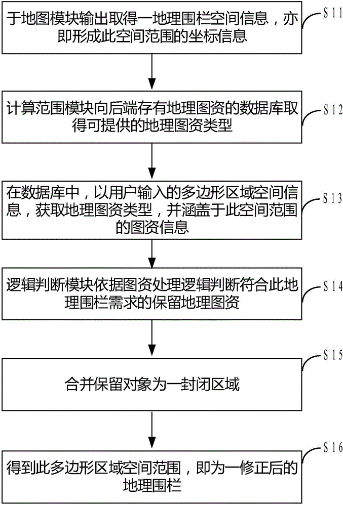
[0055] see figure 1 as shown in figure 1 As shown, it is a schematic flow diagram of the geofence automatic correction method provided by an embodiment of the present invention, and the flow includes the following steps:

[0056] In step S11, the spatial information of a geographical fence is obtained from the o...


PUM


Abstract

The invention discloses a geographic fence automatic correction method. The invention mainly utilizes the space range automatic correction method of the polygon. The geographic fence automatic correction method comprises steps of using geographic fence space information, expressing the geographic fence coordinator serial and the image resource demand type of the geographic fence, like some buildings, some roads, can correspond to the image resource information types like the buildings, the roads, obtaining the demand image resource demand type covered by the geographic boundary, performing successive comparison on the needed image resource object and the geographic coverage area rate, determining the practical geographic object corresponding to the geographic object which is considered as a reservation object, calculating the smallest externally-connected polygon containing all reservation object range, and obtaining the corrected geographic fence.

Description

technical field [0001] The present invention relates to a geofence correction method, in particular to a geofence technology (Geofence) using location-based services (Location Based Services, LBS), through the definition of a spatial range, it can correspond to the geofence automatic correction method of the actual geographical area . Background technique [0002] A geofence is a spatial area, which can contain actual geographic map object information. Its related applications include detecting the relationship between mobile devices containing GPS signals and this geofence, including entering, leaving, staying, etc., or further Provide follow-up services for mobile devices under specific conditions. For example, mobile devices that enter the geo-fence range cut off the Internet connection service. It can be seen that the geo-fence range is a link that affects the quality of service in the application scenario. [0003] For different application requirements, geo-fences are...

Claims


Application Information

Patent Timeline
IPC IPC(8): G06F17/30G16B45/00
CPCG06F16/29
Inventor 陈怡芳杨仕丞游佳明刘至善
Owner CHUNGHWA TELECOM CO LTD
Why Eureka
Try Eureka