Positioning method and system based on safe driving map and binocular recognition of traffic signs

A traffic sign recognition and positioning method technology, applied in the field of positioning methods and systems based on driving safety maps and binocular traffic sign recognition, can solve problems such as inaccurate positioning, no GPS signal, and inability to locate vehicles, and achieve strong safety performance. , the effect of high positioning accuracy and high positioning efficiency

Active Publication Date: 2016-06-29
WUHAN KOTEI TECH CORP
View PDF7 Cites 65 Cited by
  • Summary
  • Abstract
  • Description
  • Claims
  • Application Information

AI Technical Summary

Problems solved by technology

However, because the positioning error that GPS positioning technology can achieve is about 10 meters, it is very inaccurate to use GPS positioning technology to locate the vehicle; for vehicles driving on bridges, tunnels, or encountering bad weather such as heavy rain and snow, GPS will There is no signal state, so the vehicle cannot be located
Therefore, if only relying on the GPS positioning method to locate the vehicle, it will inevitably bring huge hidden dangers to the driving safety of intelligent vehicles, so how to accurately locate the vehicle is a technical problem to be solved urgently in this field

Method used


Image

  • Positioning method and system based on safe driving map and binocular recognition of traffic signs
  • Positioning method and system based on safe driving map and binocular recognition of traffic signs
  • Positioning method and system based on safe driving map and binocular recognition of traffic signs

Examples


Embodiment Construction

[0056] In order to make the objectives, technical solutions, and advantages of the present invention clearer, the following further describes the present invention in detail with reference to the accompanying drawings and embodiments. It should be understood that the specific embodiments described here are only used to explain the present invention and are not used for Limit the invention.

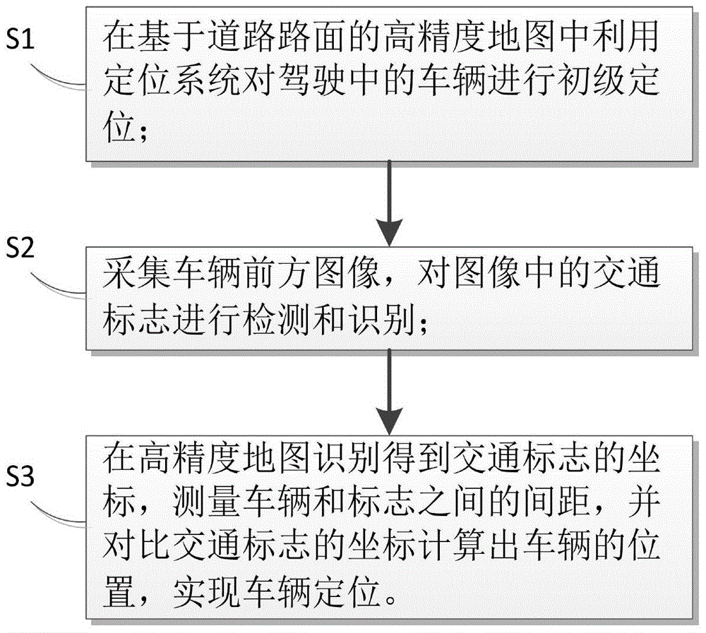
[0057] Such as figure 1 As shown, the embodiment of the present invention provides a positioning method based on driving safety map and binocular traffic sign recognition. The positioning method based on driving safety map and binocular traffic sign recognition includes the following steps:

[0058] S1. Use the positioning system to perform primary positioning of the driving vehicle in the high-precision map based on the road surface;

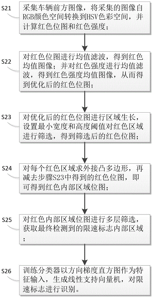
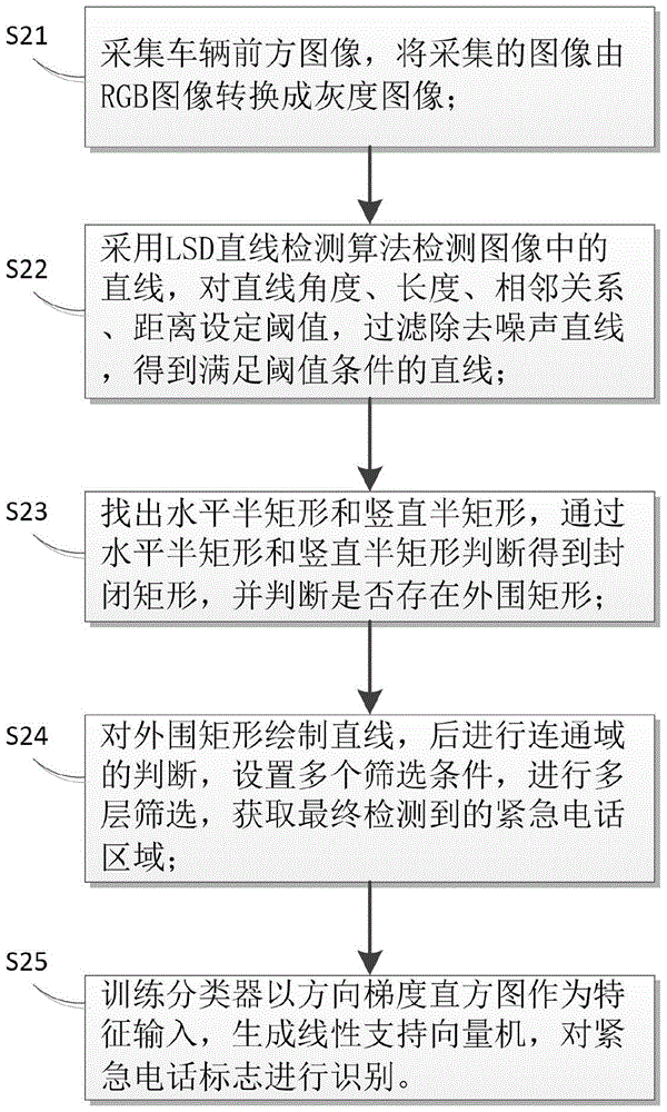
[0059] S2. Collect images in front of the vehicle, and detect and recognize traffic signs in the images;

[0060] S3. Recognize the coordinates of the traffic sign...


PUM


Abstract

The invention provides a positioning method and system based on a safe driving map and binocular recognition of traffic signs. Primary positioning of a running vehicle is carried out via the positioning system by means of a high-precision map. Meanwhile, images of the part in front of the vehicle are acquired, and traffic signs in the images are detected and identified. Coordinates of the traffic signs are recognized and obtained in the high-precision map, the distance between the vehicle and the signs are measured, and the position of the vehicle is calculated by comparing the coordinates of the traffic signs. In this way, the vehicle is positioned. By means of the invention, on the basis of traditional navigation data, acquisition of road traffic signs is added, roads signs are adopted to help positioning vehicles, the distance between vehicles and traffic signs is measured according to coordinates and sizes of signs which are recognized by left and right cameras, and vehicle positions are calculated according to spatial coordinates of traffic signs which are already stored in the high-precision map, so that submeter-level coordinate positioning is provided and a lane-based topology network is established.

Description

Technical field [0001] The invention relates to the technical field of vehicle networking, in particular to a positioning method and system based on driving safety maps and binocular traffic sign recognition. Background technique [0002] With the development of computer science and robotics, intelligent driving vehicles have been widely used in many aspects such as military, civil and scientific research. It concentrates the latest research results of multidisciplinary such as structure, electronics, cybernetics and artificial intelligence. ,have a broad vision of application. [0003] For intelligent driving vehicles, vehicle positioning is a key component, and vehicle positioning is the basis for intelligent vehicle decision-making and control. GPS (Global Positioning System, Global Positioning System) positioning technology is generally used to locate the vehicle. The vehicle determines the location of the vehicle according to GPS positioning technology, performs trajectory p...

Claims


Application Information

Patent Timeline
Patent Type & Authority Applications(China)
IPC IPC(8): G06K9/00
CPCG06V20/582
Inventor 苏晓聪刘伶俐朱敦尧
Owner WUHAN KOTEI TECH CORP
Why Eureka
Try Eureka