Location map displaying method, orientation judgment method and device
A display method and a technology of a location map, applied in the field of communication, can solve problems such as the inability to indicate the relative positional relationship of devices, and achieve the effects of improving entertainment, good record of travel, and strong practicability
- Summary
- Abstract
- Description
- Claims
- Application Information
AI Technical Summary
Problems solved by technology
Method used
Image

Examples
Embodiment 1
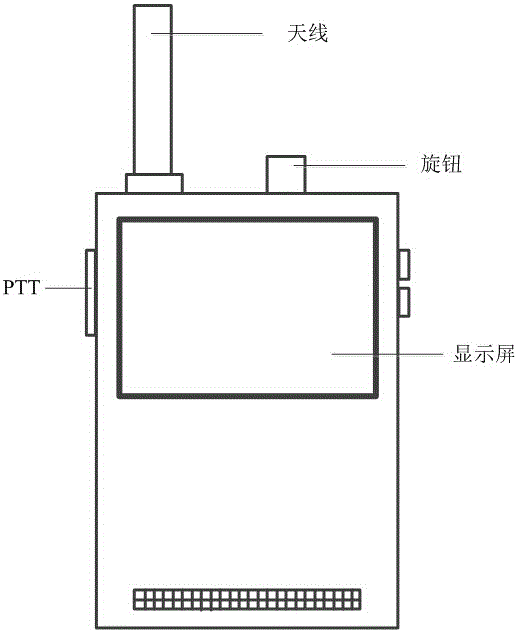
[0054] Such as figure 1 As shown, a smart intercom device is disclosed, including a shell with three-proof functions, a circuit board fixed inside the shell, a microphone for recording audio, a speaker for playing sound information, an antenna for radio frequency transmission, A battery for powering the intelligent intercom device and a display screen for displaying communication information; the microphone and the speaker are electrically connected to the circuit board; there are grid holes on the shell where the microphone and the speaker are installed correspondingly; the The display screen is inlaid on the shell and electrically connected to the circuit board, and the position on the shell corresponding to the display screen is made of transparent material; the antenna is installed on the circuit board through the interface on the shell; the shell is used to adjust the volume and The knob of the channel is electrically connected to the circuit board; the button on the shel...
Embodiment 2
[0085] In Embodiment 1, an intelligent intercom device with a Bluetooth unit is disclosed. In the intercom device, the main function of Bluetooth is to connect a smart phone or other smart devices to obtain GPS coordinates. Therefore, on the basis of the above-mentioned embodiments, a smart intercom device is further disclosed, including a shell with three-proof functions, a circuit board fixed inside the shell, a microphone for recording audio, and a microphone for playing sound information. Speaker, antenna for radio frequency transmission, battery for powering intelligent intercom equipment and display screen for displaying communication information; said microphone and speaker are electrically connected to the circuit board; the shell is correspondingly installed with the microphone and speaker There are grid holes at the position; the display screen is inlaid on the casing, and is electrically connected to the circuit board correspondingly, and the position corresponding t...
Embodiment 3
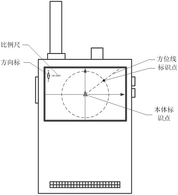
[0104] In the above-mentioned Embodiment 1 and Embodiment 2, a method for displaying a location map on an intelligent intercom device is disclosed. Since the smart intercom device itself has a Bluetooth function, the smart devices connected to it, such as smart phones, all have display screens, and have electronic compass and GPS functions. Therefore, the invention discloses an intelligent intercom device, which is compatible with The smartphone cooperates to display a map of the location on the screen of the smartphone. Such as Figure 9 It is a flow chart of displaying a location map on a smart device in the present invention, a method for displaying a location map on a smart phone, and the execution steps include:
[0105] S1, start the position map display software on the smart phone, that is, start the position map display command, and display the body identification point representing the current position in the center of the display screen, such as Figure 10 It is a ...
PUM
 Abstract
Description
Claims
Application Information
 - R&D
- Intellectual Property
- Life Sciences
- Materials
- Tech Scout
- Unparalleled Data Quality
- Higher Quality Content
- 60% Fewer Hallucinations
Browse by: Latest US Patents, China's latest patents, Technical Efficacy Thesaurus, Application Domain, Technology Topic, Popular Technical Reports.
© 2025 PatSnap. All rights reserved.Legal|Privacy policy|Modern Slavery Act Transparency Statement|Sitemap|About US| Contact US: help@patsnap.com