
Small unmanned aerial vehicle remote sensing-based slope deformation detection and calculation method

A technology of machine remote sensing and unmanned aerial vehicle, applied in the field of slope deformation detection and measurement based on small UAV remote sensing, can solve the problems of lack of slope deformation monitoring, analysis and processing methods, and restrictive application, and achieve low implementation cost , high precision effect

Inactive Publication Date: 2016-07-20
CHINA THREE GORGES UNIV
View PDF3 Cites 69 Cited by
  • Summary
  • Abstract
  • Description
  • Claims
  • Application Information

AI Technical Summary

Problems solved by technology

However, if the above methods are directly applied to slope deformation monitoring and analysis, it is not enough to rely solely on high-resolution remote sensing results. It is also necessary to ensure that the remote sensing results have high absolute position accuracy in plane position and elevation. Ensure high registration accuracy between multi-phase results, so that it is possible to carry out slope deformation monitoring and analysis including deformation detection and accurate measurement
This involves the comprehensive application of a series of methods such as small UAV system construction, image control point layout and measurement, on-site image acquisition, indoor remote sensing result generation, multi-phase result registration, slope deformation detection and measurement, etc. The lack of such a complete and efficient set of high-precision slope deformation monitoring and analysis processing methods based on small UAV remote sensing seriously restricts related applications.

Method used


Image

  • Small unmanned aerial vehicle remote sensing-based slope deformation detection and calculation method
  • Small unmanned aerial vehicle remote sensing-based slope deformation detection and calculation method

Examples


Embodiment Construction

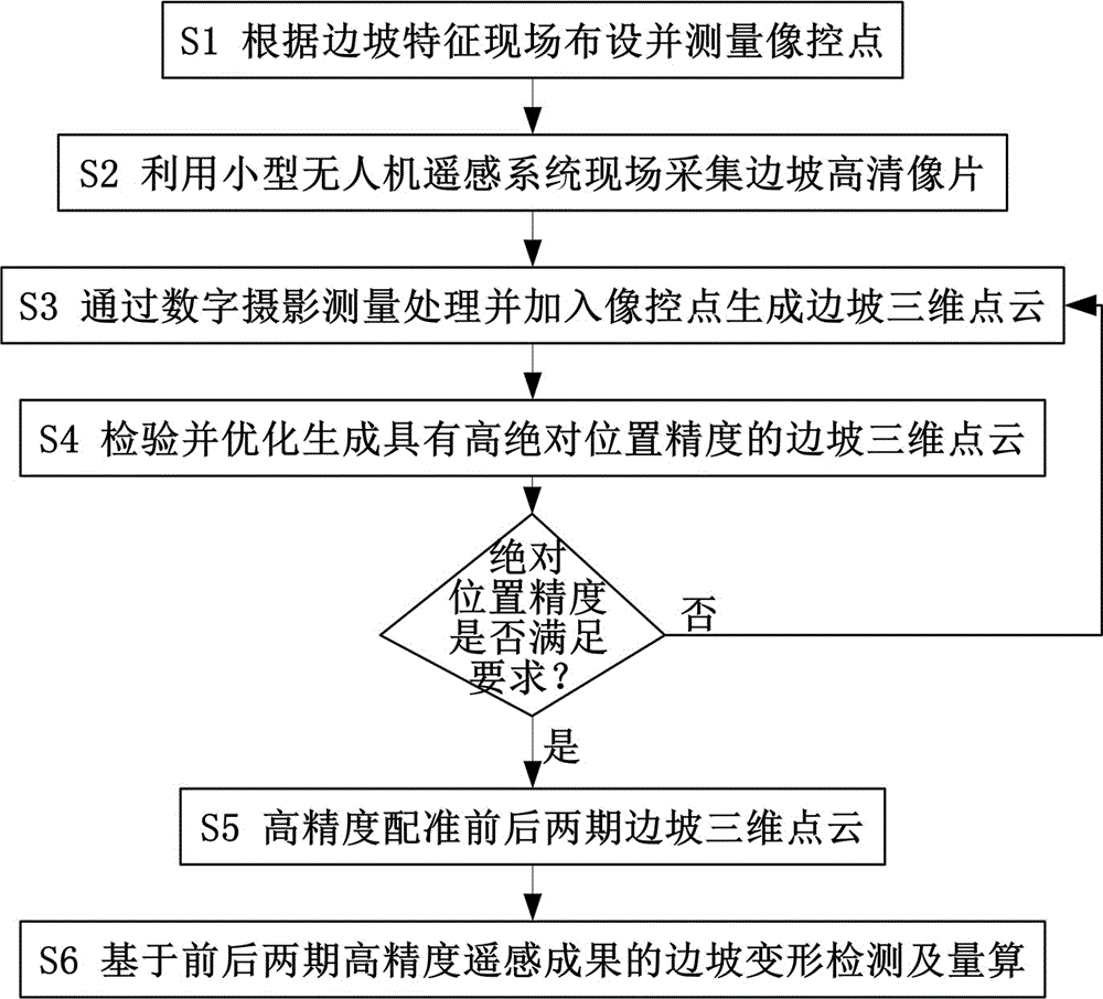
[0026] The technical solution of the present invention will be further described with reference to the accompanying drawings. Such as figure 1 As shown, the method for detecting and measuring slope deformation based on remote sensing of a small UAV according to the present invention, the technical steps include: arranging and measuring the image control point S1 on-site according to the characteristics of the slope; using the remote sensing system of the small UAV Acquire high-definition pictures of slope S2 on site; generate slope 3D point cloud S3 through digital photogrammetry processing and add image control points; verify and optimize the generation of slope 3D point cloud S4 with high absolute position accuracy; high-precision registration of the front and back Three-dimensional point cloud S5 of the slope; S6 of slope deformation detection and measurement based on the high-precision remote sensing results of the previous two periods.

[0027] S1. Deploy and measure image c...


PUM


Abstract

The invention relates to a small unmanned aerial vehicle remote sensing-based slope deformation detection and calculation method which comprises the following technical steps: arranging and measuring image control points on the spot according to characteristics of a slope; acquiring a high-definition image of the slope on the spot by virtue of a small unmanned aerial vehicle remote sensing system; processing and adding the image control points to generate a three-dimensional slope point cloud by virtue of digital photogrammetry; performing checking and optimization to generate a three-dimensional slope point cloud with high absolute position accuracy; highly accurately registering three-dimensional slope point clouds of earlier and later periods; performing slope deformation detection and calculation on the basis of high-accuracy remote sensing results of an earlier period and a later period.

Description

Technical field [0001] The invention relates to a slope deformation monitoring and analysis method, in particular to a slope deformation detection and measurement method based on remote sensing of a small drone. Background technique [0002] Monitoring and early warning is the most important and effective means to prevent slope deformation or instability, and it has been widely recognized. The surface displacement monitoring represented by GPS has become an indispensable core technology method in slope monitoring due to its high precision, low cost, and strong adaptability. However, the current surface displacement monitoring is the so-called "point" monitoring method, that is, it can only monitor the displacement and deformation data of a limited number of discrete points deployed on the slope in advance, but cannot know the continuity of the entire slope surface space. Deformation field information. In order to overcome this shortcoming, the "surface" monitoring method repres...

Claims


Application Information

Patent Timeline
Patent Type & Authority Applications(China)
IPC IPC(8): G01C11/04G01B11/16
CPCG01C11/04G01B11/16
Inventor 黄海峰林海玉王焕易武易庆林张国栋吕奕铭张磊李剑南胡乃利柳青雷德鑫童时岸刘凯
Owner CHINA THREE GORGES UNIV
Learn More