Monocular SLAM (Simultaneous Localization and Mapping) method capable of creating large-scale map

A large-scale, map-based technology, applied in image analysis, image data processing, instruments, etc., can solve problems such as inability to build environmental maps, inflexibility, and inability to guarantee flexibility

Inactive Publication Date: 2016-08-03
BEIJING ROBOTLEO INTELLIGENT TECH
View PDF3 Cites 15 Cited by
  • Summary
  • Abstract
  • Description
  • Claims
  • Application Information

AI Technical Summary

Problems solved by technology

On the other hand, zoom sensors, such as depth or stereo cameras, have certain limitations, they can provide reliable measurements without guaranteeing their flexibility
[0003] Aiming at the problems existing in monocular SLAM, some related solutions have been proposed before: the feature-based method, although it can simplify the overall problem through decoupling, has serious limitations; the direct method, that is, direct visual measurement The distance method avoids the limitation by optimizing the geometry directly on the image enhancement, but this method is a purely visual distance measurement, which can only track the motion of the camera locally, and cannot construct a continuous global environment map containing closed loops. ; A pose map method based on RGB-DSKAM was proposed before, which combined with geometric errors allows the tracked scene to have less texture, and the limb movement is relatively rigid and inflexible

Method used


Image

  • Monocular SLAM (Simultaneous Localization and Mapping) method capable of creating large-scale map
  • Monocular SLAM (Simultaneous Localization and Mapping) method capable of creating large-scale map
  • Monocular SLAM (Simultaneous Localization and Mapping) method capable of creating large-scale map

Examples


Embodiment Construction

[0033] The present invention will be further described below in conjunction with the accompanying drawings.

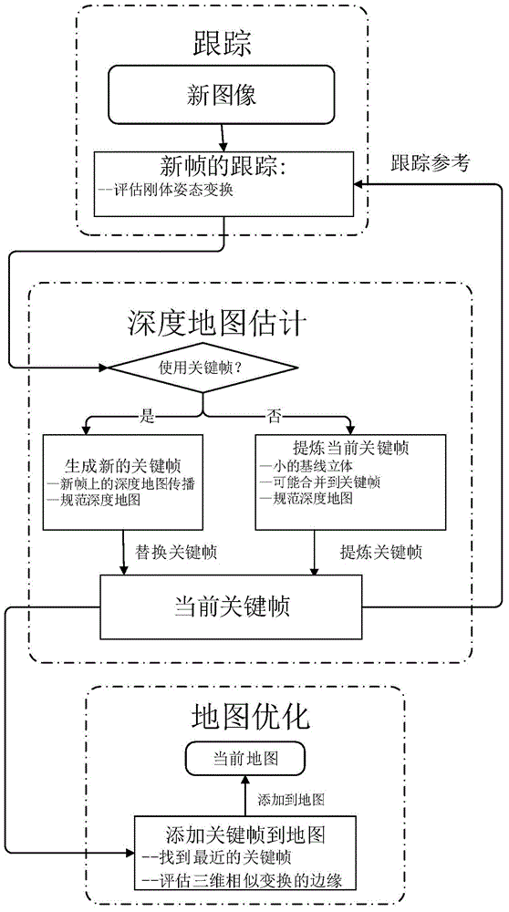
[0034] Such as figure 1 Shown: a kind of monocular SLAM method that can create large-scale map, it is characterized in that: adopt following steps:

[0035] Step 1: Tracking of the new frame: the tracking component continuously tracks the new camera image (640×480 pixels) at a frequency of 30 Hz, and evaluates the rigid body pose of the image relative to the current frame in, Represents a set of Lie-algebra transformations, ξ represents a transformation in the set, initialized with the pose of the previous frame.

[0036] Step 2: Depth map estimation: The component uses the tracked frame to extract or replace the current keyframe, and extracts depth by filtering many frame-by-frame small baseline stereo comparisons plus interleaved spatial orthogonalization; if the camera moves too far, New keyframes are initialized from the existing projected points closest to th...


PUM


Abstract

The present invention provides a monocular SLAM method that can create large-scale maps by using direct image alignment correction, explicit absorption and detection of scale drift; then adding filter-based semi-dense depth map estimation to achieve continuous With large-scale environment maps, the method not only tracks camera motion locally, but also maintains and tracks it on a global map of the environment. At the same time, the method can also run in real time on the CPU of an ordinary PC, and as a ranging method, it can even run on modern smartphones.

Description

technical field [0001] The invention belongs to the field of robot synchronous positioning and map creation, and relates to a monocular SLAM method capable of creating large-scale maps. Background technique [0002] In recent years, with the further development of computer technology, digital image processing technology and image processing hardware, computer vision has begun to receive widespread attention in the field of robotics. SLAM is the abbreviation of Simultaneous Localization and Mapping (Simultaneous Localization and Mapping). This concept was first proposed by Smith, Self and Cheeseman in 1988. This method describes the situation in which the robot starts from an unknown location in an unknown environment and then explores the unknown environment: the robot repeatedly observes the environment during the movement, and then locates its own position and posture according to the environmental characteristics perceived by the sensor, and then according to its own posi...

Claims


Application Information

Patent Timeline
Patent Type & Authority Applications(China)
IPC IPC(8): G06T7/20
Inventor 廖鸿宇孙放
Owner BEIJING ROBOTLEO INTELLIGENT TECH
Why Eureka
Try Eureka