Road accumulated snow calamity monitoring and early warning method based on multisource remote sensing data

A technology of remote sensing data and roads, applied in the field of remote sensing, can solve problems such as difficult early warning and prediction, and achieve low-cost, fast and accurate monitoring and early warning effects

Inactive Publication Date: 2016-09-07
COLD & ARID REGIONS ENVIRONMENTAL & ENG RES INST CHINESE
View PDF4 Cites 25 Cited by
  • Summary
  • Abstract
  • Description
  • Claims
  • Application Information

AI Technical Summary

Problems solved by technology

Due to the lack of professional meteorological data in many mountai

Method used


Image

  • Road accumulated snow calamity monitoring and early warning method based on multisource remote sensing data
  • Road accumulated snow calamity monitoring and early warning method based on multisource remote sensing data
  • Road accumulated snow calamity monitoring and early warning method based on multisource remote sensing data

Examples


Embodiment Construction

[0020] Below in conjunction with accompanying drawing and embodiment, do further explanation again with technical scheme of the present invention:

[0021] A method for monitoring and early warning of road snow disasters based on multi-source remote sensing data, the steps are:

[0022] Step 1: Obtain time series snow cover remote sensing products;

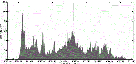
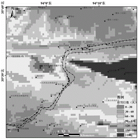
[0023] MODIS snow area MOD10A1 and MYD10A1 products are seriously affected by the weather. The existence of clouds limits the acquisition of daily cloudless snow products. Through the combination of upper and lower stars, analysis of adjacent days, adjacent pixel method, snow line to cloud judgment, passive microwave snow The cloud-free daily snow product algorithm synthesized by water equivalent is processed by cloud removal, and the MODIS daily cloud-free snow product is obtained, and the average annual snow day for many years is obtained by grid overlay calculation. The daily passive microwave temperature measurement data of S...


PUM


Abstract

The invention relates to a road accumulated snow calamity monitoring and early warning method based on multisource remote sensing data. According to the method, first of all, a cloud-free accumulated snow area product is obtained by performing cloud removal processing on a MODIS accumulated snow area product by use of a cloud removal algorithm; an accumulated snow depth product is obtained through a snow depth reversing algorithm by use of a passive microwave SSM/I and SSMI/I brightness temperature observation, for calculating a whole-road average annual accumulated snow day number of many years and a multi-year average accumulated snow thickness and determining a key accumulated snow road mileage of a whole road; secondly, by use of Landsat and high-definition satellite remote sensing image data, through a normalization accumulated snow exponent and a high-definition accumulated snow exponent threshold method extraction method, accumulated snow is identified, and accumulated snow spatial distribution of each mileage of a key road is extracted; and finally, through a surface temperature, ASTER GDEM, a gradient, an aspect and a meteorological condition, roads prone to icing and roads prone to avalanches and blowing snow are determined. According to the invention, monitoring of road accumulated snow distribution and the roads prone to icing, avalanches and blowing snow are realized by use of the multisource remote sensing data, and monitoring and early warning of road accumulated calamities are accurately realized.

Description

technical field [0001] The invention relates to the technical field of remote sensing, in particular to a method for monitoring and early warning of road snow disasters by using multi-source remote sensing data. Background technique [0002] China has a vast territory and complex topography. The snow cover is widely distributed and is easily affected by the local climate and topography. A large amount of snowfall over a long period of time causes a wide range of snow disasters, which have a great impact on all aspects of the national economy. Especially in the northeast, north, northwest and southwest regions of China, the winter is long, the wind is strong, and the snowfall is large. Snow disasters such as avalanche, wind blowing snow, and road icing along the highway frequently occur, causing road blockage and damage, and endangering the lives of local people. , normal life and economic and social development have caused serious impacts, and have become a long-term probl...

Claims


Application Information

Patent Timeline
IPC IPC(8): G06K9/00G06Q10/04G06Q50/30
CPCG06Q10/04G06Q50/30G06V20/182
Inventor 祁元王宏伟张金龙李晓英
Owner COLD & ARID REGIONS ENVIRONMENTAL & ENG RES INST CHINESE
Why Eureka
Try Eureka