Remote sensing image segmentation and identification method based on superpixel marking

A technology of remote sensing image and recognition method, applied in image analysis, image enhancement, image data processing and other directions, can solve the problems of remote sensing image inability to achieve segmentation effect, limited application, loss of boundary information, etc., to achieve the effect of excellent segmentation and recognition ability

Inactive Publication Date: 2016-10-12
HARBIN ENG UNIV
View PDF7 Cites 28 Cited by
  • Summary
  • Abstract
  • Description
  • Claims
  • Application Information

AI Technical Summary

Problems solved by technology

Overlapping division is an improved method based on fixed division. Although it can improve the accuracy to a certain extent, it still loses the boundary information of the actual area.
On the other hand, the current i

Method used


Image

  • Remote sensing image segmentation and identification method based on superpixel marking

Examples


Embodiment Construction

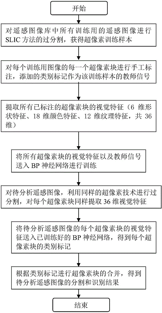
[0018] The present invention will be described in detail below in conjunction with specific embodiments.

[0019] Step 1: Use the SLIC (Simple Linear Iterative Clustering) method to over-segment all training remote sensing images in the remote sensing image library to generate superpixels. The number of superpixels depends on the resolution of the remote sensing image, and the remote sensing image with a wider area can be properly divided into more superpixel blocks. Each superpixel block is used as a training sample.

[0020] Step 2: Manually label each superpixel block of each training image, and the added category label is used as the teacher signal of the training sample.

[0021] Step 3: Extract the visual features of all labeled superpixel blocks (i.e. learning samples). Using the image visual description method provided by Duygulu (see literature [1]), 6-dimensional shape features, 18-dimensional color features, and 12-dimensional texture features are extracted for ea...


PUM


Abstract

The invention provides a remote sensing image segmentation and identification method based on superpixel marking. Superpixel segmentation results are obtained by performing over-segmentation on remote sensing images by use of a superpixel segmentation algorithm, and learning samples are obtained by performing classification marking on superpixel blocks. Then, visual features of superpixel samples are extracted, these learning samples are trained by taking marking results as teacher signal classifiers, and trained classifier information is stored. The superpixel results are obtained by performing the over-segmentation on the remote sensing images to be analyzed, a visual feature of each superpixel is extracted and then is sent to the classifiers for classification, and after each superpixel block obtains a class mark, the superpixel blocks of the same class marks are merged, i.e., all areas of the images to be analyzed obtain class information. According to the invention, the remote sensing images are prevented from being directly segmented, edge information of actual areas is reserved to a quite large degree, segmentation and identification processes are integrated together, and the segmentation and identification capabilities are more excellent.

Description

technical field [0001] The invention relates to a method for segmenting and identifying remote sensing images. Background technique [0002] Remote sensing image is an intuitive carrier of comprehensive information on ground objects. With the development of remote sensing technology, it is an urgent and complicated problem to process remote sensing images and obtain various information from them. The analysis of remote sensing images plays an important role in various aspects such as geological exploration, agriculture and forestry. Segmentation and recognition of remote sensing images is an important research topic in the field of remote sensing digital image processing. Region segmentation and classification description can achieve the purpose of recognition, classification and interpretation of image information, which has very important military and civilian values. At present, there are many segmentation and recognition methods of remote sensing images, but there is st...

Claims


Application Information

Patent Timeline
IPC IPC(8): G06T7/00
CPCG06T2207/10032G06T2207/20084
Inventor 刘咏梅李香罗扬理李金龙
Owner HARBIN ENG UNIV
Why Eureka
Try Eureka