Spaceborne radar and ground-based radar reflectivity factor data three dimensional fusion method

A technology of reflectivity factor and space-borne radar, which is applied in the direction of radio wave reflection/re-radiation, utilization of re-radiation, measurement devices, etc., which can solve the problems of large error and low resolution in height direction

Active Publication Date: 2016-10-26
南京信大气象科学技术研究院有限公司
View PDF4 Cites 25 Cited by
  • Summary
  • Abstract
  • Description
  • Claims
  • Application Information

AI Technical Summary

Problems solved by technology

However, due to the number of elevation angles in the receiver scan of GR data and the effect of beam broadening at long distances, the resolution in the height direction is still very low after resampling. In addition, th...

Method used


Image

  • Spaceborne radar and ground-based radar reflectivity factor data three dimensional fusion method
  • Spaceborne radar and ground-based radar reflectivity factor data three dimensional fusion method
  • Spaceborne radar and ground-based radar reflectivity factor data three dimensional fusion method

Examples


Embodiment Construction

[0039] The technical solutions of the present invention will be described in detail below in conjunction with the accompanying drawings.

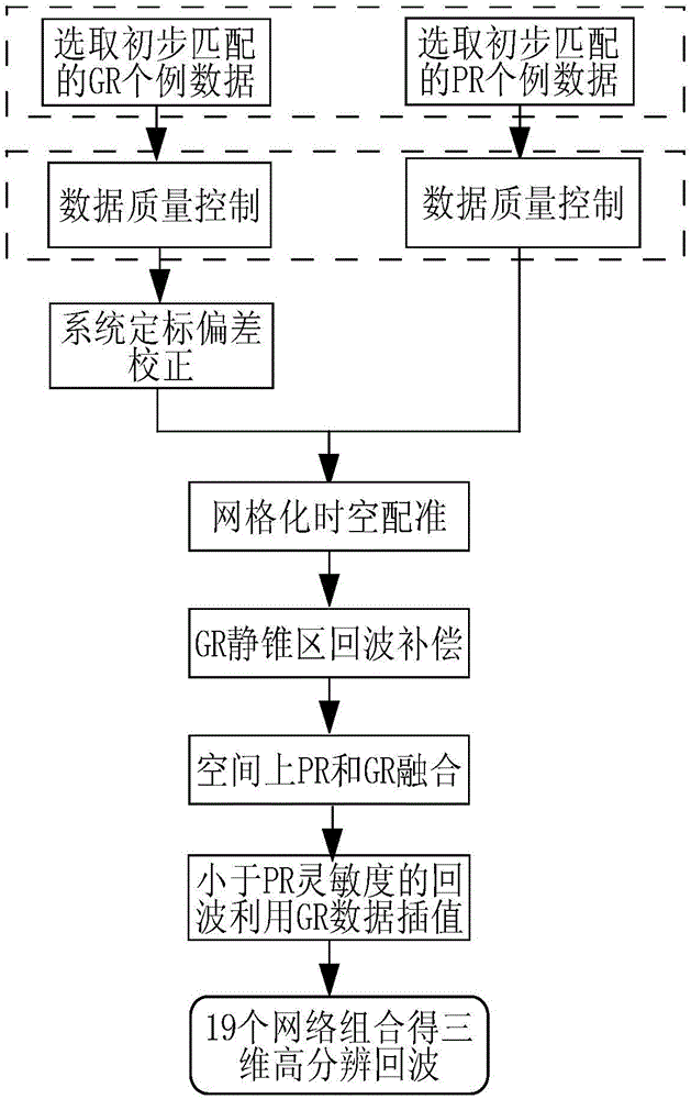
[0040] like figure 1 As shown, a three-dimensional fusion method of spaceborne radar and ground-based radar reflectivity factor data includes the following steps:

[0041] Step 1: Select spaceborne radar and ground-based radar case data that match in time and space. The selection method is to know the PR scanning swath width and its intersecting earth coordinate position, according to the swath shape model, combined with the longitude of the satellite’s trajectory at the highest latitude, the satellite orbit intercept, and the time when the orbit starts. parameters, search for transit tracks and estimated transit times. The matching area of ​​PR and GR data set when matching radar transit data is centered on the ground-based radar, with a radius of 150km (the horizontal range of reflectivity factor data sampling of GR is set to 300km×300k...


PUM


Abstract

The present invention discloses a spaceborne radar and ground-based radar reflectivity factor data three dimensional fusion method. According to the present invention, by using the precipitation radar (PR) data of high vertical resolution as the output of a neural network and the ground radar (GR) data of high horizontal resolution and low vertical resolution as the input, a non-linear relationship of a PR and a GR is established, thereby fusing into the three dimensional reflectivity factor data having the high vertical and horizontal resolution. Based on a neural network algorithm, the PR and GR reflectivity factor data three dimensional fusion is carried out to obtain a fine three dimensional structure of an intensity echo which is very important for the later applications, such as the fine detection and tracking of a middle and small-scale convective weather process, the subsequent quantitative rainfall measurement, the radar data assimilation in the middle-scale forecast, etc.

Description

technical field [0001] The invention belongs to the technical field of weather radar data processing, and in particular relates to a three-dimensional fusion method of reflectivity factor data of space-borne radar and ground-based radar. Background technique [0002] Launched in November 1997, TRMM (Tropical Rainfall Measuring Mission) is a satellite dedicated to monitoring tropical rainfall. The Precipitation Radar (PR, PrecipitationRadar) radar on board can obtain the three-dimensional structure information of precipitation and latent heat. Since the successful launch of the TRMM satellite, its rain-measuring radar has been tested and calibrated on-orbit, and has sent back a large amount of radar observation information to the ground, which can be found on NASA's official website. Compared with ground-based radar, the biggest advantage of PR is its high vertical resolution. Ground-based weather radar (GR, Ground Radar) performs cone scanning from bottom to top, and has a ...

Claims


Application Information

Patent Timeline
IPC IPC(8): G01S13/95G01S7/41
CPCG01S7/411G01S7/417G01S13/951G01S13/955Y02A90/10
Inventor 寇蕾蕾王振会黄兴友楚志刚李南许丹
Owner 南京信大气象科学技术研究院有限公司
Why Eureka
Try Eureka