Building segmentation and contour line extraction method of ground laser point cloud data

A technology of laser point cloud data and extraction methods, which is applied in image data processing, image analysis, image enhancement, etc., and can solve problems such as high time complexity, complex calculation, and inconsistent data experiment results

Inactive Publication Date: 2016-10-26
WUHAN UNIV
View PDF2 Cites 41 Cited by
  • Summary
  • Abstract
  • Description
  • Claims
  • Application Information

AI Technical Summary

Problems solved by technology

Most of these methods are based on the detailed information of the point cloud, using feature extraction or conditional constraints to complete the extraction of the contour line poin

Method used


Image

  • Building segmentation and contour line extraction method of ground laser point cloud data
  • Building segmentation and contour line extraction method of ground laser point cloud data
  • Building segmentation and contour line extraction method of ground laser point cloud data

Examples


Embodiment Construction

[0065] In order to facilitate those of ordinary skill in the art to understand and implement the present invention, the present invention will be described in further detail below in conjunction with the accompanying drawings and embodiments. It should be understood that the implementation examples described here are only used to illustrate and explain the present invention, and are not intended to limit this invention.

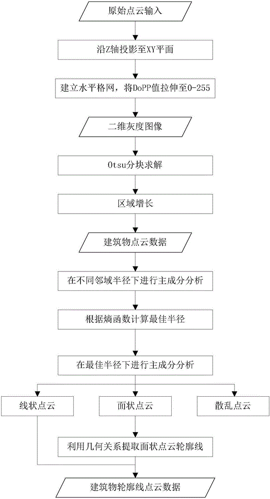
[0066] please see figure 1 A method for building segmentation and contour line extraction of ground laser point cloud data provided by the invention comprises the following steps:

[0067] Step 1: Vertically project the point cloud;

[0068] Input the original 3D point cloud, and vertically project the original 3D point cloud to highlight the point cloud distribution characteristics of different ground objects;

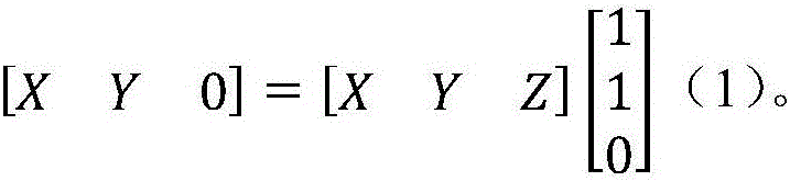
[0069] The vertical projection of the original 3D point cloud is to project the original 3D point cloud onto the X, Y plane along the Z axis, and ...


PUM


Abstract

The invention discloses a building segmentation and contour line extraction method of ground laser point cloud data. The building segmentation and contour line extraction method comprises the steps of vertically projecting a point cloud, generating a two-dimensional grayscale image, segmenting a building point cloud by adopting an Otsu algorithm, carrying out principal component analysis, conducting best neighborhood calculation, extracting contour lines and the like. The building segmentation and contour line extraction method realizes the segmentation of the building point cloud from the original point clout quickly and accurately, and completes the extraction of the building contour line point cloud in a full-automatic manner.

Description

technical field [0001] The invention belongs to the field of ground laser point cloud data processing application technology, and relates to a method for accurately segmenting buildings and automatically extracting contours from original three-dimensional point cloud data. Background technique [0002] Terrestrial laser scanning technology is an emerging three-dimensional measurement and scanning technology. The massive and high-precision point cloud data obtained by it can provide large-scale and fine three-dimensional information, better reflect the details and level information of buildings, and contribute to the construction of high-precision It is a brand new approach to digital models. While terrestrial lasers provide us with high-quality point cloud data, the amount of data has also doubled, which has created certain difficulties for us to deal with it. There are two main reasons for this problem: one is that while scanning the target building point cloud, noise and ...

Claims


Application Information

Patent Timeline
IPC IPC(8): G06T7/00G06T3/00G06K9/46G06K9/62
CPCG06T3/0031G06T3/0037G06T2207/10012G06V10/40G06F18/241
Inventor 万幼川秦家鑫何培培陈茂霖卢维欣王思颖
Owner WUHAN UNIV
Why Eureka
Try Eureka