
Method for remote sensing pre-judging of grade of engineering surrounding rocks

A surrounding rock grade and remote sensing technology, which is applied in the field of engineering surrounding rock classification, can solve the problems of difficult to meet the needs of rapid preliminary survey of tunnel engineering and protection engineering, high survey cost, and heavy workload, so as to reduce survey cost and avoid blindness Sexuality, the effect of reducing workload

Inactive Publication Date: 2016-11-23
中国人民解放军沈阳军区司令部工程科研设计所
View PDF2 Cites 5 Cited by
  • Summary
  • Abstract
  • Description
  • Claims
  • Application Information

AI Technical Summary

Problems solved by technology

[0002] The determination of the surrounding rock grade generally requires conventional ground surveys combined with relevant laboratory tests. This method has a large workload, low efficiency, and high survey costs, and it is difficult to meet the needs of rapid preliminary surveys for tunnel engineering and protection projects.

Method used


Image

  • Method for remote sensing pre-judging of grade of engineering surrounding rocks

Examples


Embodiment Construction

[0031] The present invention will be described in further detail below in conjunction with the accompanying drawings and embodiments.

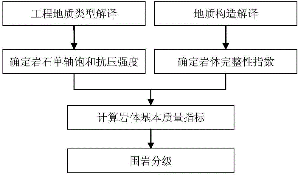
[0032] A remote sensing pre-judgment method for engineering surrounding rock grade of the present invention comprises the following steps:

[0033] Step 1, remote sensing information extraction of engineering geological types and geological structure elements, specifically includes the following sub-steps:

[0034] Step 1.1 uses satellite remote sensing as the main data source, interprets the engineering geological type by means of remote sensing information interpretation, and divides the engineering geological type into hard rock (I 1 , I 2 , I 3 , I 4 ), subhard rock (II 1 、II 2 ), soft rock (III 1 、III 2 、III 3 、III 4 ), hard soil (IV 1 , IV 2 ), common soil (V 1 , V 2 ), loose soil (VI 1 、VI 2 ), special soil (VII) level 17;

[0035] Step 1.2 uses satellite remote sensing as the main data source, interprets the geological ...


PUM


Abstract

The invention belongs to the field of engineering surrounding rock classification, and in particular, relates to a method for remote sensing pre-judging of the grade of engineering surrounding rocks. The method comprises the following steps: step one, extracting engineering geological type and geological structure factor remote sensing information; step two, determining the rock uniaxial saturated compressive strength and the rock mass integrality index; step three, calculating the rock mass basic quality index BQ; and step four, classifying the surrounding rocks. Through the steps of extraction of the remote sensing information, determination of the rock mass integrality index and the rock uniaxial saturated compressive strength, calculation of the rock mass basic quality index BQ, surrounding rock classification and the like, rapid classification of the engineering surrounding rock grade is realized, the method is not restricted by topography landform and spatial regions, avoids the blindness of data blank area working, improves the work efficiency, reduces the workload, reduces the cost for investigation, and provides reliable reference data for engineering later detailed investigation and design and construction.

Description

technical field [0001] The invention belongs to the field of engineering surrounding rock classification, in particular to a remote sensing pre-judgment method for engineering surrounding rock grades. Background technique [0002] The determination of the surrounding rock grade generally requires conventional ground surveys combined with relevant laboratory tests. This method has a large workload, low efficiency, and high survey costs, and it is difficult to meet the needs of rapid preliminary surveys for tunnel engineering and protection projects. Therefore, there is an urgent need for a large-scale pre-determined method of engineering surrounding rock grade. Contents of the invention [0003] The technical problem to be solved by the present invention is to provide a remote sensing pre-judgment method for engineering surrounding rock grades, which can meet the needs of rapid initial survey of tunnel engineering and protection engineering. [0004] In order to solve the ...

Claims


Application Information

Patent Timeline
Patent Type & Authority Applications(China)
IPC IPC(8): G01N33/24
Inventor 于德浩龙凡王康杨清雷韩天成李霞张宣宣齐文勃
Owner 中国人民解放军沈阳军区司令部工程科研设计所
Learn More