Easily-happening landslide prediction method based on remote sensing technology

A prediction method and remote sensing technology, applied in the field of engineering geological exploration, can solve the problems of landslide-prone prediction and other problems that have not yet been realized, and achieve the effect of improving the safety of engineering operations and the level of disaster prevention and mitigation, with strong focus and high reliability.

Inactive Publication Date: 2016-12-14
CHINA RAILWAY DESIGN GRP CO LTD
View PDF1 Cites 26 Cited by
  • Summary
  • Abstract
  • Description
  • Claims
  • Application Information

AI Technical Summary

Problems solved by technology

[0003] At present, survey methods based on remote sensing technology and on-site surveys can only identify landslides that have occurred. In addition, the reported landslide hazard assessment methods can only divide landslide hazard areas from a large area. These methods have not yet realized potential Prediction of prone landslides in or in engineering

Method used


Image

  • Easily-happening landslide prediction method based on remote sensing technology

Examples


specific Embodiment approach

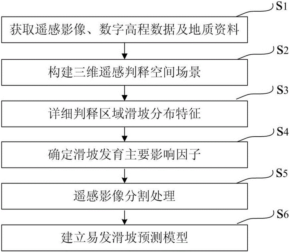
[0023] The landslide-prone prediction method based on remote sensing technology of the present invention will be further described below in conjunction with the accompanying drawings. figure 1 It is a flow chart of the method for predicting landslides prone to occur based on remote sensing technology of the present invention. Such as figure 1 As shown, the prone landslide prediction method based on remote sensing technology of the present invention comprises the following steps: S1, obtaining remote sensing images, digital elevation data and geological data; S2, constructing a three-dimensional remote sensing interpretation space scene; S3, detailed interpretation of regional landslide distribution Features; S4. Determine the main factors affecting landslide development; S5. Segment and process remote sensing images; S6. Establish a landslide-prone prediction model. The specific implementation is as follows:

[0024] S1. Obtain remote sensing image data, digital elevation da...


PUM


Abstract

The invention discloses an easily-happening landslide prediction method based on remote sensing technology. The easily-happening landslide prediction method comprises following steps of: obtaining remote sensing images, digital altitude data and geological data; constructing a three-dimensional remote sensing interpretation space scene; detailing interpretation regional landslide distribution characteristics; determining key impacting indicators of landslide growth; and carrying out remote image segmentation processing and establishing an easily-happening landslide prediction model. By use of the easily-happening landslide prediction method, prediction of hidden easily-happening landslides is achieved; the easily-happening landslide prediction method is strong in focusing ability, highly reliable, capable of providing more specific and scientific basis for engineering construction, operation maintenance, disaster prevention and reduction and the like, and capable of increasing the level of engineering operation safety and disaster prevention and reduction.

Description

technical field [0001] The invention relates to the field of engineering geological survey, in particular to a landslide-prone prediction method based on remote sensing technology. Background technique [0002] Landslides are an important type of adverse geological disasters. With the increasing frequency of human activities, the construction of railways, highways, mines, water conservancy, and factory buildings has increased the probability of landslide disasters. Taking the railway industry as an example, the landslide accidents that occurred on the Shanghai-Kunming, Baolan, Yiwan, Lanyu and other railways in recent years have caused great loss of personnel and property. During the construction of some new railway projects, landslide disasters also occur from time to time. Landslide disasters have become a major hidden danger in railway line selection and existing railway operation safety. [0003] At present, survey methods based on remote sensing technology and on-site...

Claims


Application Information

Patent Timeline
Patent Type & Authority Applications(China)
IPC IPC(8): G01S17/88
CPCG01S17/88
Inventor 刘桂卫李国和宁新稳杜辉
Owner CHINA RAILWAY DESIGN GRP CO LTD
Why Eureka
Try Eureka