Indoor map and pedestrian track matching method

An indoor map and matching method technology, applied in the field of map navigation, can solve problems such as complex matching methods, and achieve the effects of improving accuracy, reducing accumulated errors, and eliminating accumulated errors.

Inactive Publication Date: 2017-01-04
BEIJING FINE WAY TECH CO LTD
View PDF12 Cites 12 Cited by
  • Summary
  • Abstract
  • Description
  • Claims
  • Application Information

AI Technical Summary

Problems solved by technology

[0005] In view of the fact that the existing map matching method needs to design complex indoor maps, and the matching method is complicated, the purpose of the present invention is to provide real-time detection and detection based on the signal output by the sensor during the travel process on the basis of pedestrian dead reckoning. A method for matching pedestrian tracks on indoor maps with simple feature quantities, simple matching method of path lines, and high practicability

Method used


Image

  • Indoor map and pedestrian track matching method
  • Indoor map and pedestrian track matching method
  • Indoor map and pedestrian track matching method

Examples


Embodiment Construction

[0015] In order to more clearly illustrate the specific embodiments of the present invention or the technical solutions in the prior art, the following briefly introduces the accompanying drawings that are required in the description of the specific embodiments or the prior art. Throughout the drawings, similar elements or parts are generally identified by similar reference numerals. In the drawings, elements or parts are not necessarily drawn in actual scale.

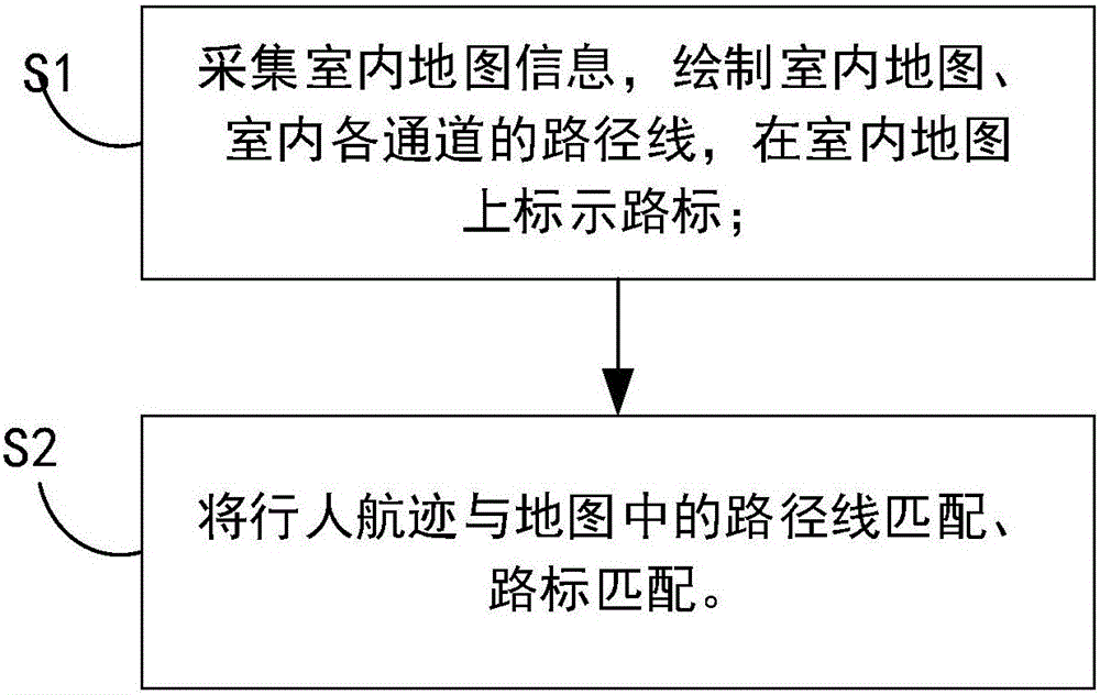
[0016] see figure 1 It shows that the present invention provides a method for matching pedestrian tracks on an indoor map, and the method includes the steps of:

[0017] Step S1: collect map information, draw indoor maps, draw path lines of narrow corridors, and mark geometric feature points on the map;

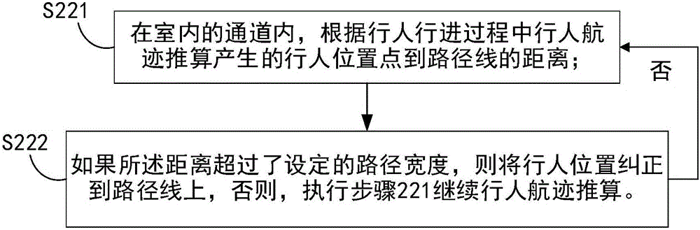
[0018] Step S2: Match the pedestrian tracks with the route lines and landmarks in the map.

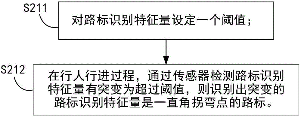
[0019] Wherein, the landmarks are geometric feature points in the indoor map, wireless local area network (Wireless Fidel...


PUM


Abstract

The invention relates to an indoor map and pedestrian track matching method, which comprises the following steps: S1, acquiring indoor map information, drawing an indoor map, drawing path lines of various indoor passages, and marking road signs on the indoor map; and S2, matching pedestrian track and the path lines and road signs in the map. In the map matching process, after the pedestrian position is matched to a geometrical characteristic point in the map, a new location point is considered as a new initial position of positioning; and in order to reduce accumulative errors, a sensor in a mobile phone is reinitialized at the new initial position. The thorough reinitialization is of great significance for pedestrian track calculation algorithm. Accumulative errors of position estimation layers are eliminated, and accumulative errors of course angle and step length estimation layers are also eliminated. Through path matching, through-wall behavior in narrow corridors can be avoided. With map matching on the basis of pedestrian track calculation, indoor positioning precision can be enhanced.

Description

technical field [0001] The invention belongs to the technical field of map navigation, and relates to an indoor map pedestrian track matching method. Background technique [0002] Currently, researchers have proposed many indoor map matching methods. [0003] For example: the terminal acquires the location point corresponding to the user's current location, and determines whether the location point is on the road segment planned in advance in the building; if it is on the road segment, directly map the location point to the terminal's map; if not on the road On the line segment, obtain the road segment closest to the location point; obtain the vertical point from the location point to the nearest road segment, and map the vertical point to the map of the terminal. [0004] Existing map matching methods perform location matching based on real-time locations. Contents of the invention [0005] In view of the fact that the existing map matching method needs to design comple...

Claims


Application Information

Patent Timeline
Patent Type & Authority Applications(China)
IPC IPC(8): G01C21/30
CPCG01C21/30
Inventor 张弛吕明熊兴玉汪冬燕
Owner BEIJING FINE WAY TECH CO LTD
Why Eureka
Try Eureka