Navigation method, device and system

A navigation method and a technology of a navigation device, applied in the fields of navigation methods, devices and systems, can solve the problem of not supporting multi-user navigation functions, etc., and achieve the effect of real-time interactive shared path planning

Active Publication Date: 2017-01-11
TCL CORPORATION
View PDF10 Cites 15 Cited by
  • Summary
  • Abstract
  • Description
  • Claims
  • Application Information

AI Technical Summary

Problems solved by technology

[0004] The purpose of the present invention is to provide a navigation method, device and system, aiming at solving the problem that the existing technology does not support the navigation function of multi-user real-time interaction and shared path planning

Method used


Image

  • Navigation method, device and system
  • Navigation method, device and system
  • Navigation method, device and system

Examples


Embodiment 1

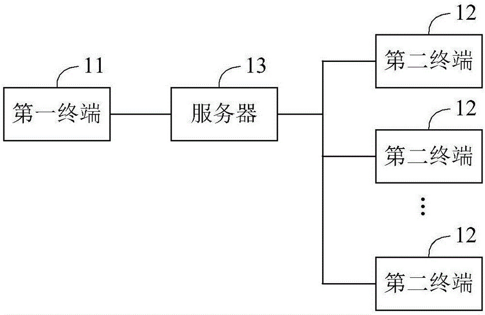
[0028] figure 1 It is a schematic structural diagram of a navigation system provided by Embodiment 1 of the present invention. For convenience of description, only the parts related to the embodiment of the present invention are shown. figure 1 The exemplary navigation system includes a first terminal 11, a second terminal 12, and a server 13, wherein the first terminal 11 is a terminal that provides navigation assistance, and the second terminal 12 is a terminal that needs to accept navigation assistance. The number of second terminals 12 can be One, or at least two. The detailed functions of the first terminal 11, the second terminal 12 and the server 13 are as follows:

[0029] The first terminal 11 imports the real-time navigation map, and sends the real-time navigation map containing the position information of a plurality of marked points to the server 13, wherein the position information of the plurality of marked points is set by the user of the first terminal and pro...

Embodiment 2

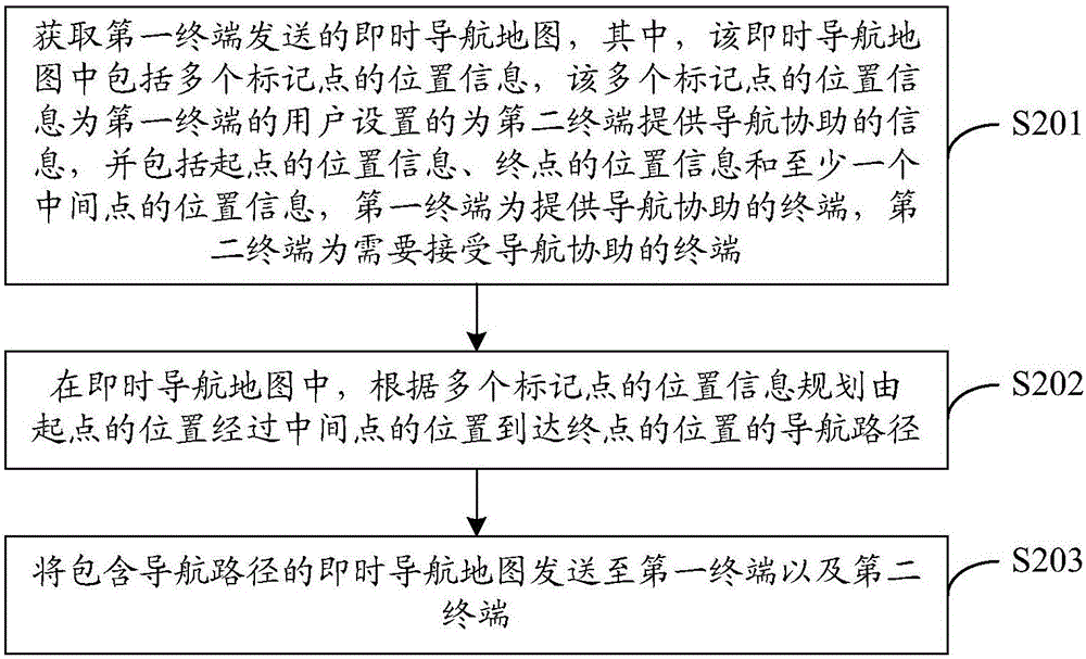
[0047] image 3 It is a flow chart of a navigation method provided in Embodiment 2 of the present invention, image 3 The execution subject of the exemplary navigation method is a server, which may be a cloud server. It specifically includes steps S201 to S203, which are described in detail as follows:

[0048] S201. Obtain the instant navigation map sent by the first terminal, wherein the instant navigation map includes position information of multiple marked points, and the position information of the multiple marked points is set by the user of the first terminal to provide navigation for the second terminal Assistance information, including the location information of the starting point, the location information of the end point and the location information of at least one intermediate point, the first terminal is a terminal that provides navigation assistance, and the second terminal is a terminal that needs to receive navigation assistance.

[0049] Specifically, when ...

Embodiment 3

[0057] Figure 4 It is a flowchart of a navigation method provided by Embodiment 3 of the present invention, Figure 4 The execution subject of the exemplary navigation method is a server, which may be a cloud server. It specifically includes steps S301 to S308, which are described in detail as follows:

[0058] S301. Obtain the instant navigation map sent by the first terminal, wherein the instant navigation map includes position information of a plurality of marked points, and the position information of the plurality of marked points is set by the user of the first terminal to provide navigation for the second terminal Assistance information, including the location information of the starting point, the location information of the end point and the location information of at least one intermediate point, the first terminal is a terminal that provides navigation assistance, and the second terminal is a terminal that needs to receive navigation assistance.

[0059] Specific...


PUM


Abstract

The invention is suitable for the field of communication, provides a navigation method, device and system, and aims to solve the problem that the prior art fails to support navigation functions of multiuser real-time interaction and sharing path planning. The method comprises the steps that a server obtains a real-time navigation map sent by a first terminal, wherein the real-time navigation map comprises position information of a plurality of marked points; in the real-time navigation map, a navigation path which starts from the position of a starting point, passes the position of a middle point and reaches the position of an end point is formulated according to the position information of the marked point; the real-time navigation map containing the navigation path is sent to the first terminal and a second terminal. According to the technical scheme of the navigation method, device and system, the navigation path is formulated through the server according to the marked points, and the real-time navigation map containing a navigation path is sent to the first terminal and the second terminal to achieve the navigation functions of real-time interactions and sharing path planning among multiusers.

Description

technical field [0001] The present invention relates to the communication field, in particular to a navigation method, device and system. Background technique [0002] At present, all kinds of mobile terminals and automobiles have the function of navigating through the Global Positioning System (GPS), such as Google Map, Baidu Map, Apple Map, Gaode Map and other applications. You can enter the destination address , find the location of the destination on the map, plan the route and navigate. [0003] However, the navigation function in the prior art is often only for a single user, and there is no route planning and navigation function for real-time interaction among multiple users. For example, when two users have an appointment, each user navigates through their own car navigation equipment, and the users cannot see each other's real-time travel route, so they cannot provide navigation guidance to each other. When optimizing the path, users cannot provide mutual feedback...

Claims


Application Information

Patent Timeline
Patent Type & Authority Applications(China)
IPC IPC(8): G01C21/28G01C21/34
CPCG01C21/28G01C21/3438
Inventor 火焰郭宏智
Owner TCL CORPORATION
Why Eureka
Try Eureka